
I was standing on the edge of a cliff near the town of Sohra one hazy evening in early February 2019, watching the day turn to night. Before me great dark jungle-clad hills rose and fell like monstrous waves as they marched east into the misty purplish distance, the tops of the ridges slowly fading until they seemed to merge with the sky.
Tiny clusters of twinkling lights began to appear in the haze a long, long, way off. These were villages and small towns all the way over on the opposite side of a vast system of deep gorges carved by the Umrew River and its countless tributaries. To trek across this impenetrable labyrinth of stone, jungle, and rivers means climbing down and up endless slopes, navigating narrow and treacherous trails, crossing streams over precarious bridges, and finding one’s own route between villages that often speak different languages and have remarkably distinct cultures.
Gazing over the blue and purple valleys, I could name most of the villages that were just turning on for the night. I had swum in many of the streams hidden below in the dark folds of the mountain ridges. Sohkynduh and Tluh villages, the Muor and Lyngngam rivers, the large Khasi settlements of Kongthong and Khrang, were all places I had been through, albeit briefly, in 2015, when I had trekked west through the Umrew gorge from the town of Pynursla to the town of Sohra.
That long hike had been at once brutal and beautiful, full of immense, at times life-threatening, challenges, which were amply rewarded with the opportunity to explore breathtaking natural settings and witness one of the world’s most fascinating cultures. But once the walk was over, my feeling wasn’t that I had gained a deep understanding of the Khasi Hills. Just the opposite: the trek had only illustrated the sheer magnitude of that which I still didn’t know.
During the winter in southern Meghalaya, the days often don’t end in proper sunsets. The air is too full of dust coming up from Bangladesh and filled with smoke generated by the ubiquitous shifting cultivation fires that are a feature of the local agriculture during the dry season. When the day fades, the world to the east gradually recedes into a fog that turns from orange to purple to black.
As the electric lights of distant villages brightened with the advancing night, so too did the little growing rings of flickering orange as far off fields were reduced to ash in preparation for future crops. The Khasi Hills never look quite so impassable as they do at that time of day. It struck me for a moment that I must have been insane to have crossed the Umrew gorge back in 2015 without being familiar with its people, valleys, or paths.
Then I caught myself.
In 2019, I was attempting to walk over five times as far, mostly through areas that I knew practically nothing about, or, occasionally, through places that I had been in just long enough to recognize that they were incredibly difficult to cross on foot. In a few days, I would set off on the longest hike I had ever taken, and I didn’t know the way.
Darkness fell as a fire started on the ridge across from the cliff, an orange ring quickly growing wider in the black. Murky red light bathed the land around me, while the sound of vegetation crackling and popping as it went up in flames was carried faintly on the wind.
It was time to return to my room in Sohra and get some rest. Withdrawing from the edge of the cliff, I made my way back to town across grassy limestone moors, following a very rough and recently constructed dirt track.
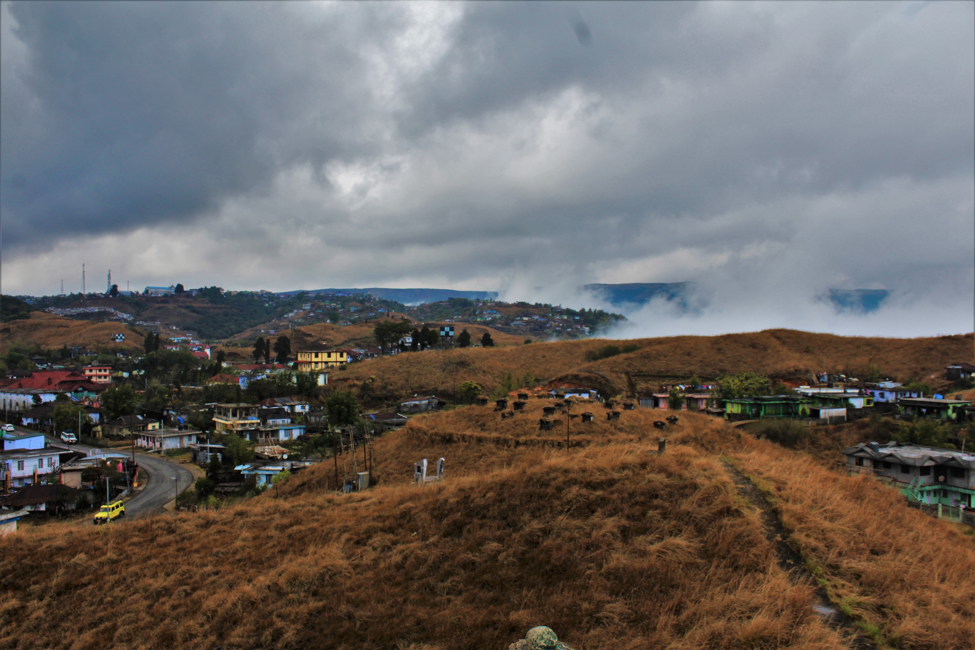
I’ve never been to a place that has changed faster than Sohra. Even in the few years I’ve been coming, whole regions of semi-wild empty space at the edge of town have been tamed and covered in houses; spots formerly well off the tourist map have become swamped with visitors from elsewhere in India and from around the globe; a giant limestone factory that once constantly belched clouds of smoke into the air has been forced by the Indian central government to drastically cut its emissions. In years past, the environs of Sohra were so riddled with lethally unstable rat-hole coalmines that in places the landscape started to resemble an endless Swiss cheese. Back then, whole hills subsided as their innards were pulled out and the dodgy coalmines vomited foul black and red effluent in the monsoon season. In 2019, crackdowns on the illegal mines had picked up, so the rat holes were fewer, smaller, and better hidden. The scars of the mining were slowly healing, and the air was cleaner, but the tourists were coming in greater numbers than ever before.
Now ambling up a long, dark, empty road at the outskirts of town, far from what little hustle and bustle Sohra had to offer, I found myself heading towards an isolated building that I didn’t remember from my last trip. It was oddly lit with bright green and red neon, and it loomed presumptuously three stories above the small houses and rocky moors around it, shining out in solitary menace into the night, the eerie effect rendered not the slightest bit less sinister and strange for being unintentional. Out front was a very pricey-looking electric signboard which read: “Rain Drops Tourist’s Homestay: A place for homely stay.”
Rain Drops hadn’t existed a few years before. Neither had most of the new hotels and homestays that had popped up in Sohra like mushrooms after a wet spell to take advantage of the tourism boom, itself a result of the rapid expansion of the Indian middle class starting in the 1990s. Since then, India has fully embraced travel, and Sohra, with its waterfalls and caves and monsoon views, is where a good chunk of India wants to go.
But the tourists are only the most recent wave of visitors Sohra has been subjected to over the tumultuous course of the past two centuries.
In 1826, following the First Anglo Burmese War, the British East India Company was formally recognized as the chief power in the Brahmaputra Valley and the hills which bordered it. Though the native Khasi kingdoms were still in most respects self-governing entities at this time, the treaty nonetheless gave the British the freedom to operate as they wished in the area, and to rapidly consolidate their power. They would rule until Indian independence in 1947 and leave an indelible, complex, mark on the Khasi Hills.
The initial European expeditions into the region around Sohra were led by a certain Mr. David Scott, who bore the title of Agent to the Governor General on the Northeast Frontier of Bengal, a post which made him the Company’s chief official in the Khasi Hills. It was Scott who established the first significant British settlement in the area, a sanitorium in Sohra where it was hoped that the cool upland climate would prove beneficial to European convalescents. Starting in 1828, Scott commenced the construction of a road over the hills that would pass through Sohra, connecting the Brahmaputra Valley with the plains of Sylhet. But the project did not go forward unresisted; in 1829, a British surveying party was attacked by warriors led by the famous Khasi freedom fighter U-Tirot Sing, an event which touched off several years of both open and guerrilla warfare in the region. After the British authorities put down most (but not all) of the Khasi rebel chiefs, Sohra became the headquarters of the Company’s Sylhet Light Infantry Regiment.
Following the soldiers came the naturalists, the missionaries, and the businessmen. By the middle decades of the 19th century, the first detailed accounts of the region’s people, flora, and fauna were beginning to emerge from British travelers who passed through Sohra. In particular, an 1844 description of the region in the Journal of the Bengal Asiatic Society by Sir Henry Yule provides a valuable, if brief, window into the valleys around Sohra as they appeared at the time. It is, crucially, this account which contains the first historical mention of Meghalaya’s living root bridges. Following in Yule’s footsteps a few years later came one of the 19th century’s preeminent naturalists, the botanist Sir Joseph Dalton Hooker, who wrote extensively about the Khasi Hills in his work Himalayan Journals; or, Notes of a Naturalist In Bengal, The Sikkim and Nepal Himalayas, The Khasia Mountains, &c. Hooker was most impressed by the area’s flora, which he considered “in extent and number of fine plants, the richest in India, and probably in all Asia.” Writing about the landscape around Sohra, Hooker gushed that he did not “know any spot in the world more calculated to fascinate the naturalist who, while appreciating the elements of which a landscape is composed, is also keenly alive to the beauty and grandeur of tropical scenery.” But regarding the Khasis themselves, Hooker is far from laudatory, priggishly dismissing them as “sulky intractable fellows…wanting in quickness, frankness, and desire to please, and obtrusively independent in manner.”
At around the same time Protestant missionaries ensconced themselves in Sohra, and it was from the town that Christianity spread further and further into the recesses of the Khasi Hills, a process which continues to this day. Though other denominations arrived earlier, it was Welsh Calvinist Presbyterians who first gained a solid foothold in the area, and their impact on the region’s culture is not to be understated. The missionary Thomas Jones came to Sohra in 1841, and sensing that the gospel could be better transmitted among the Khasis with the written word, endeavored to create a system to transcribe the purely spoken local language. Employing a slightly modified Roman script, Jones used the dialect around Sohra to set down what is now commonly considered to be the “official” version of the Khasi language, even though countless other variations exist throughout the hills. This is the language that is taught in schools, and which most Khasi literature is written in.

Thomas Jones is perhaps the most important European figure in Khasi history. And yet, counter to the narrative that missionaries in India were simply colonial vanguards, his activities were far from appreciated by the British administration in Sohra. This was because he publicly butted heads with the primary British trading concern in the region during the 19th century, Inglis & Co. Founded by George Inglis at Sylhet (in present day Bangladesh) during the 1790s, this organization had already established a monopoly over trade in such commodities as oranges, coal, and limestone between the hills and the planes even before Europeans set foot in the highlands. By the time Jones was operating at Sohra, George Inglis’s half native son Harry had been conveniently appointed assistant to David Scott’s successor as Political Agent, Colonel F.G. Lister, who was also, scandalously, Harry’s father-in-law. This position allowed the younger Inglis to, in effect, act as the local magistrate, an arrangement which he promptly turned to his personal advantage.
With the combination of his deep knowledge of the area and his authority as Lister’s second in command, Harry Inglis came to fully dominate the economy of the Khasi Hills by the middle of the 19th century, conducting his business with an incredible degree of corruption as he employed his own constabulary to bully and extort Khasi landowners and European business rivals alike. A steady stream of legal cases began to pile up against him, though these were summarily deflected in the local courts that Inglis and Lister controlled.
Among the staunchest challenges to Inglis’s corrupt practices were a set of complaints brought against him by Thomas Jones, who accused the trader of swindling the Khasis out of their fair earnings and establishing an unjust monopoly over almost every aspect of the local economy. In response, and to make an example for anyone else who might be tempted to raise a stink, Inglis sent members of the Sohra police to Jones’s house under the pretext of inquiring if the missionary had a permit to reside in the area, though their actual task was to intimidate the missionary and his family. When Inglis’s men broke down the door and started threatening Jones’s wife, the missionary realized it was high time to flee. Fearing for his life, he escaped through the jungle to Guwahati, and from there travelled on to Calcutta, though he soon thereafter died of Malaria, age 39.
The various unhappy proceedings surrounding Inglis did not go unnoticed beyond the Khasi Hills. Accordingly, the colonial administration in Calcutta, then capitol of the Raj, dispatched a judge by the name of A.J.M. Mills to investigate the rumors of legal irregularities emanating from Sohra. After travelling to the region and seeing the situation for himself, Mills compiled a lengthy document entitled Report on the Khasi and Jaintia Hills 1853 in which he observed that the local legal system had broken down to such an extent that the courts had “lost the entire confidence of the people. The state of feeling amongst the natives is such that no one would dare to bring an action or give evidence against Mr. Inglis. Every person I have conversed with spoke in this strain, and the proceedings of the court certainly strengthen the impression.”
Mills took the galaxy of complaints being lobbed at Inglis seriously enough to advise that the courts in Sohra should be removed from the control of the Agent and placed under the jurisdiction of the Company’s judge in Sylhet. In response, the Governor General of India at the time, Lord Dalhousie, is recorded in Mills report as agreeing that “measures [needed to] be taken for improving the present Agency by changing the Assistant and by limiting the powers of the Agent.” But by the time Mill’s report was finished, Inglis had already left his station as Assistant, though his business remained intact, and no serious attempt was ever made to prosecute him for his multifarious crimes.
Inglis died in England in 1860, though that wasn’t quite the end of his tale. During his checkered career the trader would often enter into lease agreements with Khasi landowners which would only expire when he was dead and buried. The story one hears in Sohra is that, in order to keep the fear of his name alive as long as possible amongst the natives, Inglis stipulated that after his death his embalmed corpse should be preserved and displayed unburied in perpetuity, thereby allowing the trader to advance his claims from beyond the grave. Fulfilling this wish must have been quite a logistical feat on the part of Inglis’s family: The mortal remains of the late trader had first to be pickled in England and then somehow transported all the way back across the world to the Khasi Hills, one presumes at great expense. In any case, his corpse did not take its station at Inglis’s family bungalow near Sohra until nearly ten years after his death. Whether the locals were then obliged to hold to their agreements with the famously corrupt and by that point long dead businessman is an interesting question.
But, for all his oppression and efforts to remain a force in the Khasi Hills even after shuffling off his mortal coil, Harry Inglis is little talked about these days, and never in a positive light. When he does come up, it’s usually when someone is providing an example of the worst the British Empire had to offer Northeast India. But Thomas Jones is celebrated across the hills as the father of the Khasi alphabet, and his legacy lives on in every Khasi language schoolbook, newspaper, and bible. He even has his own public holiday, held every June 22nd.
More and more buildings appeared on either side of the road as I walked along. Then I came to an intersection with another road that led off to the south, towards the border town of Shella.
Turning to the right, I arrived at a small market at the intersection of the Shella road and State Highway 5, in a part of Sohra called Saitsohpen. Here one finds a collection of hole-in-the-wall restaurants with names like Halari, Jemis, 7Trep, etc., which all have similar menus of cheap greasy dishes aimed mostly at budget tourists. Homesick mainland Indian visitors can sample passable local renditions of Aloo Parathas and Puri Bhaji while cash-strapped traveling Westerners can order breakfasts of French toast and scrambled eggs.
The restaurants in Saitsohpen aren’t where you go to find Khasi cuisine. They’re where you go to eat a hearty but not-too-adventurous meal before hiking down thousands of steps to the village of Nongriat, home of the world-famous Double Decker root bridge, and the focal point of tourism in the Sohra area. The root bridge and the restaurants are inextricably linked. They are, to use a slightly disparaging term, on the Beaten Path: that fabled route travelers so often claim they want to get away from, usually as they stick right to it.
But for all the bad press it gets, the Beaten Path has its advantages. When you’re staring down a long, difficult, dangerous journey, frequently the best idea is to adhere to the proven route to your destination. When one is in the wild and the Beaten Path is not just a metaphor but an actual track across the ground, it can be downright stupid to leave it, and risk falling off a cliff, or sinking into a swamp, or getting lost in the jungle. After all, it’s the Beaten Path that’s most likely to actually lead somewhere.
Even though Nongriat has become more well-known over the years, I still think that the people who make the trek there, having travelled from all over India and the world, are adventurous. But they generally do want to have some idea of what to expect when they get there. They want to know that they’ll have food to eat, a place to sleep, and something to do. The overwhelming majority of travelers are, not without reason, averse to the idea of sleeping hungry on a rock while lost in a foreign land. That’s not a vacation.
But from the experience I already had trekking through the gorges of Meghalaya in places well-off the Beaten Path (which are 95% of the state), I suspected that some hunger and sleeping on rocks was in the cards over the next few weeks. The walk I was contemplating, if it even proved feasible, meant forging my own route through the hills, intersecting the Beaten Path at a few points but never following it.
I stopped at 7trep restaurant to have a dinner of fried rice and mushroom-chicken soup. The joint was crowded with Indian tourists, most of them minding their own business. One middle aged couple, however, was haranguing the proprietor, an old Khasi lady who’s been there as long as I’ve been coming to Meghalaya, trying to get her to refund their money. The couple’s order of mixed fried rice had arrived insufficiently mixed for their taste, so they began insinuating that the good staff at 7trep Restaurant were ripping them off with a lack of meat diversity. But the owner stood by her mixed fried rice, triggering a long tedious conversation as the lady took the customer’s plate and pointed out which pieces of meat embedded in the food were chicken and which were pork. The couple then countered that there was no mutton, whereupon the owner dug through the steaming plate, and, after some searching, triumphantly located an unmistakable mutton-chunk. Then the couple scoffed at how hard she had to look to locate this singular chunk, so the proprietor started digging for more. And so it went.
The idea of sleeping on a rock in the jungle was starting to grow on me.
Finally, having had their uneaten mixed fried rice thoroughly dissected, the disgusted Indian couple paid up and left without eating the meal, the man shooting the proprietor a dirty look on his way out.
With the inane argument finished and peace settling over the room, I pulled out my smart phone, opened Google Maps to the rough, complex, terrain of Southern Meghalaya, and tried to plot a course for the five-week trek that was ahead of me.
Easier said than done.
Relying on Google Maps in Meghalaya is unwise. This is because a fair number of the towns and villages in the state are either mislabeled, or not labeled at all. For example, there is a village in the canyons east of the town of Pynursla called Nonghulew. Google Maps does show the name of the village, but it’s hanging erroneously in the jungle about a kilometer and a half from where it should. That might not sound like much. On flat terrain with plenty of roads, it wouldn’t be. But in the southern Khasi Hills, where distances can often be gauged more accurately in vertical rather than horizontal lines, a kilometer and a half makes a vast difference. The location marked Nonghulew on Google Maps is over 600 meters lower in altitude than the actual position of the village. A 600-meter mistake is a big one.
The place names in Google Maps for the more remote parts of Meghalaya almost seem as though they’ve been deliberately jumbled for the express purpose of confounding anyone who would actually want to use the app to navigate. Sometimes, a village’s name will be on the wrong side of a giant gorge; sometimes, two neighboring villages will have their names swapped; sometimes, major settlements will have no names at all; and sometimes, as a punchline for the Google Maps Meghalayan Geographical Comedy Routine, a random, tiny, virtually unheard-of village will be correctly labeled.
The situation is so bad that I’ve found that the most reliable way to pin down the name of a village in an untraveled area of the state on Google Maps is to see if it has a large Presbyterian Church. These are often labeled by local parishioners, who know the names and locations of the villages far better than Google does. As for finding any other maps that accurately show the positions of the villages in the grand canyons of southern Meghalaya, I can say with some certainty that that’s a fool’s errand, having been the fool who tried to find such a thing.
But even if one is able to ascertain the names and locations of villages in the Khasi Hills, Google Maps does not, at least in any detail, show how to get from one to the next. Two villages may be quite near each other yet have no direct path between them. Sometimes, one gets to a village and finds that the only way to walk to the next one is to stumble through jungles and across rivers via trekking routes that the locals themselves rarely follow. Given these navigational uncertainties, the course I was plotting was more of an educated guess as to what dots I needed to connect than a detailed plan.
One thing about the trek that was entirely predetermined was the amount of time I had to work with. By the middle of March, I needed to be in the city of Shillong, the capitol of Meghalaya, to attend an academic conference on living root bridges. This left me all of five weeks to cross the valleys of the Southern Khasi Hills. It’s true that having more time would have been much, much, better. But for that, I’d need to have more money. Sadly, I was on a shoestring budget. Just getting to India ate up a big chunk of my funds. Getting back would eat up most of the rest. I’d have to be painfully frugal with both my time and money.
I knew where I wanted to start: The town of Ranikor, which is located at the (debatable) western fringe of the Khasi Hills. From here, I’d keep walking east until the people no longer spoke the Khasi tongue.
Departing Ranikor, I would make my way to the nearby villages of Nongnah and Ngunraw. As for Nongnah, I had heard that there was a large living ladder on its land, automatically making the village of interest for its living architecture. Beyond that, I knew absolutely nothing about the place. My next target, Ngunraw, (pronounced: nuh-gun-raw) was only about four kilometers to the north of Nongnah, but separated from it by a deep valley. Ngunraw looked like a place I needed to visit simply because it was one of the most peculiar geographical features in the whole of Meghalaya. The village (the name of which I had determined from its well-marked church on Google Maps), occupied a tiny mesa surrounded by cliffs and steep slopes. The top of the plateau was blanketed in dozens of close-set houses, like a dense little island of civilization thrust up into the sky. Again, I knew little about the village beyond its location and appearance from space, but I felt reasonably sure I’d encounter interesting things by going there.
The (hazy) plan from that point was to somehow walk east into the valley of the Umngi River, and then to a village called Mawpdai, where I had been told several years before that there was a “Living Tunnel” formed from a ficus elastica tree. It was unclear whether this was a natural feature or a piece of living architecture, but regardless, it seemed like something I should investigate.
After Mawpdai, I would press on to the mid-sized town of Mawsynram. While Sohra is only 15 kilometers from Mawsynram as the crow flies, the two are separated by the Grand Canyon of the Umiam River, the single most difficult patch of terrain in southern Meghalaya, where a fifteen-minute walk is a full day’s exercise. The villages nestled inside the canyon, such as Thieddieng, Nongsluid, and especially Nongsteng, consist of groups of houses affixed, barely, to the sides of slopes that are just shy of cliffs.
Having briefly crossed the Umiam gorge on several short treks in years past, this was somewhat familiar ground. I knew the names of many of the villages in the canyon and had a basic understanding of the lay of the land. Still, before I had only been in the gorge long enough to collect a series of leads regarding living architecture, but not to pursue them. I knew that several of the villages had once been surrounded by a significant number of root bridges, but that many of these structures had disappeared in recent decades. On the trek ahead, I hoped to investigate the area much more thoroughly.
Once I was done in the Umiam gorge, I’d walk back to Sohra and rest up for a few days before pressing on into the next vast canyon-system of the Khasi Hills, that of the Umrew River.
The Grand Canyon of the Umiam may be the most rugged part of the southern Khasi Hills, but the gorge of the Umrew is the most complex. The sheer number of separate valleys and remote settlements here make the canyon a world entirely unto itself that one could profitably spend a lifetime exploring. While I had been in this labyrinth of folded hills and interconnected gorges before, there were still large swathes of the drainage of the Umrew River that were entirely unknown to me.
One thing I did know, however, was that the eastern rim of the maze-like gorge was exceptionally rich in living architecture. In a narrow sliver of vertiginous, densely forested territory between the Umrew and the eastern lip of the canyon there are far more documented living root bridges than in all of the rest of Meghalaya or, for that matter, the planet. As a cultural practice, living architecture is nowhere more important than it is here, in the root bridge capitol of the world.
My plan was to cross much of the western and central parts of the Umrew canyon relatively quickly, prioritizing the eastern, living-architecture rich part of the gorge. I intended to work my way towards a village called Nongblai, where I had been told there was a high concentration of impressive root bridges.
From Nongblai, I would then push further east into a great swath of the southern Khasi Hills that I knew virtually nothing about: the multiple gorges of the upper Umngot River system.
Partitioned from the Umrew gorge by a narrow peninsula of tableland is the furthest east of the Khasi Hills’ grand canyons, that of the Umngot River. A relative of a friend had told me of a village in the gorge called Lynshing where he thought living root bridges might be found (though he hadn’t seen them himself). Google Maps put the village in a random spot in the jungle at the bottom of a canyon. My suspicion was that the actual settlement was one of several unmarked clusters of buildings on the top of a ridge to the west of the manifestly erroneous label, though the only way to confirm this was to plunge into the forbidding canyonlands and hope for the best.
The easternmost gorge of the upper Umngot marks the end of the Khasi speaking world. Beyond it, overlooking the river, are the mid-sized settlements of Amlarem and Jarain, where the local tongue becomes a dialect of the Jaintia language. Jarain, then, was where I would finish…unless I got lost and wound up in Amlarem, which was always a possibility.
It was no use trying to estimate how far I’d be walking in the days ahead. This was because I wouldn’t just be hiking from village to village; I’d also be attempting to learn as much as I could about each settlement along the way. Given that Khasis tend to have such a close relationship with the land, finding out what makes a village’s culture unique usually means going out and climbing all over the adjacent countryside. This is immensely rewarding, but the kilometers pile up.
Back in Google Maps, I focused in on Jarain until the screen on my phone was entirely taken up by the little town. Then I zoomed out, and out, and out. The number of slopes and canyons and plateaus and rivers multiplied exponentially. Finally, I brought the map out until I could see the entire region I intended to traverse, from Ranikor to Jarain. In a straight line, it was only a mere 90 kilometers across, but I knew full well that my path through the canyonlands of the southern Khasi Hills would twist and turn and rise and fall and go around in plenty of circles. And it could very well come to a dead end.
From space, the trek looked completely impossible.
“I must be nuts,” thought I.
After dinner I walked back to my home for the past few nights, a little room in By the Way backpacker’s hostel run by an old friend of mine named Heprit Kynta.
By the Way is, more than anything else, a state of mind, as the actual physical location of the hostel is surprisingly difficult to pin down. It’s sort of sprinkled around a large plot of grassy tableland. The lot the hostel occupies is collectively owned by the Kynta family, who are simultaneously running several other enterprises on the land, renting out space to tenants for small businesses, and living there.
When I first stumbled into By The Way in 2012, the world was already quickly changing around it. Tourism had established itself in Sohra, but it was only a fraction of what it would become in the following years. Crucially, there was little in the way of low-cost accommodation in town. At the same time, Nongriat was growing in popularity as a destination for travelers. As this happened, slowly but surely, much of the tourism focus in that village shifted from day trippers to backpackers who were actually staying a night or two. When those folks left Nongriat, a by no means insubstantial hike consisting of 500 meters uphill on stairs, they often wanted a place to sleep once they made it back to Sohra. Seeing this, Heprit opened up a few rooms in a two-story concrete building that his family owned next to State Highway 5, and then asked for a price that these early, exhausted, adventurers could afford.
At a time when most of what little accommodation there was in the area was priced at several thousand rupees per night, Heprit’s budget approach put him well ahead of the curve as far as the tourism market was concerned. For a good long while he virtually had Southern Meghalaya’s backpacker economy to himself. In those days, all manner of eccentric foreigners from the four corners of the globe would darken Heprit’s door, making By the Way an unlikely crossroads of the universe. Shady, broke, pot-smoking Israeli ex-special forces hippies could be seen rubbing shoulders with upper class (though also pot-smoking) Bangalorean engineering students and wealthy long-travelling Japanese backpackers on their way to Turkmenistan.
Back then, visitors had no idea what to do when they reached Sohra beyond trekking to Nongriat and gazing at waterfalls from a small collection of overlooks. This meant that a: less people came to begin with, and b: visitors had no choice but to stay a while if they wanted to learn what was interesting about the place. This led to a constantly surreal, hopping, scene at By the Way in those early years. But over time, the hostel quieted down as the market in hotel rooms in Sohra went from extremely under served to radically oversaturated. By early 2019 there were hotels popping up by the dozen, distributing the tourists, and their rupees, more evenly across town.
After walking back through the early February chill of the evening, I returned to my room. There were no other visitors that night. No hippy of any race or nationality was in evidence. Heprit himself had gone off to Shillong on family business. By the Way didn’t feel like itself.
Upon opening the door and turning on the light, I was greeted by one of the most dreaded sights of the backpacker experience: a tiny hotel room strewn floor, beds, tables, and chairs, with gear. A blanket of rain clothes, Ziplock bags full of chargers, packets of dried dates, jars, socks, mosquito repellant, razors, water-filters, notebooks, camera gear, etc. was spread out before me.
I hadn’t finished packing, and I was starting early the next day.
Now I resolved to wrestle with the task at hand. If you’ll recall, my plan was to start the trek in Ranikor, and then work my way back to Sohra for a few days’ rest before pushing on to Jarain. This meant that I could leave a certain amount of stuff at By the Way, and then pick it up if I thought it would be needed on the second half of the long walk. Overall, this was convenient. But at the time it was a source of extreme stress. It meant I had to decide what to leave and what to take.
Determining what to bring for a long walk is a science, though far from an exact one. The heavier your backpack is, i.e., the more contingencies you’re prepared to deal with, the harder it will be schlepping the backpack from place to place. For example, having redundant layers of clothes, extra socks, an extra jacket, a really nice fluffy warm hat, all can come in handy in cold weather. But what if the weather confounds expectations? What if you’ve packed for snow and ice and then find yourself walking in an unseasonably warm spell? Then you’ll be dragging around a useless fluffy warm hat that adds weight and takes up valuable space. So, what if you risk it, and forego packing for cold weather? Your pack will definitely be lighter. But what if it then turns cold? You’ll be out shivering in the wilderness, feeling stupid for not having packed that big fluffy hat.
Is there a middle ground? Could one pack a merely moderately fluffy, medium-sized hat? A hat that was just the perfect fit, which would be just warm and fluffy enough to be efficacious, but also just small enough not to take up an annoying amount of space if you never used it? Well, once you’ve split that many hairs, you’ve expended a giant amount of time and mental energy selecting the perfect hat; time and mental energy that could have been better spent packing any number of vastly more important items.
Then there’s another factor which throws all the others out of whack: money. A person with a sufficiently large budget can afford high-end trekking poles, nice expensive sunglasses, a signal flare launcher, jet pack, etc. I was not such a person. I had virtually no money. Just getting to India ate up a big chunk of my budget. Getting back would eat up most of the rest. You’d think that would simplify things a bit just by narrowing down the choices. But no. Packing on a budget is agony. A well-off person might have an overwhelming selection of expensive gear to choose from, but my choice was between newly bought cheap gear that might break and the old, heavily used gear I had lying around my house…which might also break.
Fortunately, I had some experience in the Khasi Hills (otherwise I wouldn’t have tried something so ridiculous as walking all the way across them). I knew, in a very general sort of way, what the terrain would be like and what range of weather conditions I needed to be prepared for. I had a vague notion of the scale, if not the particulars, of the task ahead.
The only real certainty about the weather was that it would get worse as I went along. You’d think that January would be colder than April. In absolute terms, perhaps it is, but in the Khasi Hills, when the rains start up in the spring, slowly building up to the official monsoon season, whole weeks begin to disappear into a dark cold foggy clamminess, and you start to feel a wet dankness spreading like mold down into your bones.
To deal with rain, I had a big umbrella; an item that’s both cumbersome and essential (at least if it’s big enough to be useful. In a proper Khasi Hills shower, a little umbrella is functionally the same thing as no umbrella at all). I also had a rain jacket, but the problem with those is they take a while to put on and can be hard to dig out of a trekking bag. In Meghalaya, torrential showers can come out of nowhere. For a rapidly deployable rain defense, umbrellas are best. I carried mine strapped to the outside of my trekking bag, where I could access it in an instant.
I also had an excellent, high quality, lightweight Goretex tarp my friend Kenny lent me. You might be thinking: “How is one tarp better than another, providing they both keep the rain out?” Having backpacked with a heavy-duty blue plastic tarp of the sort the local vegetable hawkers and illegal coal miners use, I can say from experience that those take up a huge amount of space, add a lot of weight, and are a real pain in the ass. Having a functional lightweight emergency shelter on this trip courtesy of Gortex was a huge blessing.
(In case you’re wondering, I’m in no way connected to Goretex. I’m just genuinely enthusiastic about that tarp).
One of the heaviest items I’d be bringing with me was a black plastic garbage bag full of trail food. This included a large packet of almonds, several family-sized bags of imported beef jerky, and two great packages of dried dates I had picked up in a convenience store in Guwahati. To wash these down, I had a big glass jar of Nescafe Instant coffee. The jar, I freely admit, was an inconvenient, heavy, thing to carry around, but it was an item I couldn’t do without. I’m a bit of a caffeine addict, and sometimes tea just won’t do. On long exhausting days, with kilometers behind and unguessed adventures ahead, a great big jolt of caffeine makes the hills go by quicker.
These items added quite a bit to the weight of the trekking bag. I might have been able to make do with less. The problem was that there was no way of guessing just how much food would be required in the days ahead, which in turn meant that I always had to be prepared for a worst-case scenario.
Mostly, I’ve had good luck getting food at the villages I’ve stayed at. Khasi hospitality is generous, and you’re not likely to go completely un-fed for any length of time in their company. That said, the problem with hospitality is that you can’t be sure what you’re going to get, and you can’t complain (well…technically you could, if you’re an ass and don’t mind the risk of turning an entire village against you). A morning meal might be a huge fulfilling mound of rice and vegetables, or it might be a few drops of sugarless black tea and a single small mushy yam.
Or, you might be completely lost in the jungle and have to provide your own breakfast.
Also cluttering the trekking bag were two brand-new water filters. Once I was walking, water would be the single heaviest thing that I would be carrying. And the most important. While Southern Meghalaya is blessed with innumerable streams and rivers, the sheer arduousness of hiking in the Khasi Hills can force the fluid out of you like a wet sponge being squeezed. In the dry season running water can be harder to locate than you might think, especially in steep areas with little ground cover or exposed stone outcroppings. In wet weather these places flow with cascades and rivulets, but at other times long ascents can mean thousand-meter climbs without anything to drink.
Early in my travels in Meghalaya, I once found myself lost, miles from a village, and completely out of water. On that occasion, I wound up having to dig into a streambed that was dry on the surface and use an arrangement of sticks and palm leaves to direct a trickle of water to refill my bottle. While I was proud of myself for having Macgyvered water out of the ground, from then on I determined always to keep a filter with me while trekking, and to fill my bottles at every possible opportunity. In the end, it’s better to have lots of water and be uncomfortable than need lots of water and die of thirst.
The packing process did not go quickly. What it consisted of was me trying to find every single tiny piece of stuff that I thought I could do without. I settled on cutting the number of socks that would go with me by fifty percent. With some reluctance, I decided to leave half the dried dates, and one of two family-sized bags of beef jerky. But all the coffee was coming.
It wasn’t until after 1 A.M. that I finally had all of the stuff sorted out, everything that I was going to leave behind now filling a huge black plastic garbage bag that would be kept for a few weeks in one of Heprit’s storerooms.
I’d successfully shaved off what felt like a good eight pounds from my trekking bag.
And it still weighed a ton.
Lying in bed, I wondered what the coming days would bring, and what my chances were of crossing the whole region between Ranikor and Jarain entirely on foot. Plenty could go wrong. It always can. I could get sick, or twist an ankle, or fall off a cliff, or get hit by a car, or be captured by dacoits, or have a tree fall on me, or get caught in a landslide. Or, most likely, find myself in some sticky situation that I hadn’t even considered beforehand.
I gave myself 50/50.
If you enjoyed this post, please consider supporting me on my Patreon page. There, you can download an extended edition of my book The Green Unknown which includes several chapters available exclusively on Patreon, as well as access a whole slew of other perks.

