
In early 2019, I walked across the Khasi Hills of Northeast India.
It wasn’t easy.
But where are the Khasi Hills? What are they like? Who lives there?
When I first ventured to the hills, all the way back in 2010, I would have found those questions relatively easy to answer. I’d read the short section on Northeast India in my Lonely Planet guidebook, and so could trot out a tidy little list of facts about the region: The Khasi Hills were a range of the foothills of the Himalayas situated in the tiny state of Meghalaya, the ‘Abode of The Clouds’; Cherrapunji, a town in the highlands close to the border of Bangladesh, received more rainfall than any other spot on the globe; the hills themselves were completely blanketed in thick tropical rainforests and inhabited by an ethnic group more closely related to Cambodians than to most Indians; and in one village called Nongriat, the people made living bridges from the growing roots of rubber fig trees.
But then I travelled to the region again. And then I went a third time. And a fourth. And so on. With every subsequent visit I’ve learned more about the Khasi Hills, and the result has been that my tidy little list has steadily grown longer and messier and fuzzier around the edges. Now it’s morphed into something more like an impressionist painting: it makes a coherent picture if you stand back from it, but the closer you get, the more chaotic and diffuse it becomes.
As I’ve learned, the Khasi Hills are not foothills of the Himalayas, even if geologists do maintain that the forces which built the Himalayas also played a role in the hill’s development. Cherrapunji, known in the local language as Sohra, can claim some world precipitation records, such as the most rain measured in a year in an inhabited place and the most rain recorded over 48 hours, but the notion that it is “the rainiest place on Earth” is hotly contested. Mawsynram, a town about 15 kilometers to the west of Sohra, has also proudly made its own claim of being the world’s soggiest spot, though there the assertion is that the town has received the most measured precipitation over a ten-year period. The Khasi Hills are also not, as is often reported, completely covered in tropical rainforests. Large parts of them are, to be sure, but the hills rise so precipitously from the immense flatness of Bangladesh to the south and the alluvial soils of the Brahmaputra valley to the north that the higher elevations are alpine in appearance and are covered in pine forests that would not look out of place in the American West. As for the titular Khasi people of the Khasi Hills, it’s a fact that their language is more closely related to the Khmer tongue of Cambodia than it is to, for example, Hindi or Tamil. But it’s still only a distant cousin. To my knowledge, Cambodians and Khasis don’t have any recorded historical connection. One is not likely, as a traveling friend of mine once speculated, to stumble into Angkor-Wat-like ruins deep in the valleys of Southern Meghalaya.
Finally, it’s true that there is a village in the Khasi Hills named Nongriat where bridges have been grown out of the roots of rubber fig trees. But Nongriat is not the only village to have created such living infrastructure. There is in fact a huge swath of territory in which the Khasi people have generated architecture from rubber fig, or ficus elastica, plants. When I first visited in 2010, I had thought of living root bridges as no more than a very localized curiosity in the vicinity of Nongriat Village. Now I view them as one of the most unique architectural achievements of the human species.
In short, The Khasi Hills are bitterly hard to characterize succinctly, that is, if one isn’t willing to take their rough contours and flattened them out into smooth, easily digestible, factoids. But then one hasn’t really characterized the hills at all. At their best and at their worst, literally, figuratively, and everywhere in-between, the one thing the Khasi Hills never are is flat.
The Khasi Hills are located among the furthest extremities of India, well east of the so-called Chicken’s Neck, or Siliguri Corridor, that strange little isthmus of territory, only 22 kilometers wide, where Bangladesh and Nepal nearly meet. Beyond the Chicken’s Neck begins one of Asia’s great geographical/cultural/natural/political (the list could go on) mixing zones: Northeast India. Tectonically speaking, this is the point where a corner of the Indian Plate is colliding with the Eurasian Plate, thrusting up a vast angle of mountains. To the north, the Himalayas stretch across Bhutan, Tibet, and the Indian state of Arunachal Pradesh, while to the east the Patkai Range runs along the Indo-Burmese border. Yet the Khasi Hills are not, technically, part of either the Patkai or Himalayan mountains. Rather, they have been formed by the erosion of what geologists refer to as the Shillong Plateau, a massive expanse of the earth’s crust made of limestone and granite that was forced up into the sky in one giant chunk. Whereas the slopes of the Himalayas are the result of the buckling and tilting of the ground, those of the Shillong Plateau are places where fast moving rivers have violently cut their way straight down into tableland.
Still, the great mountains to the north and east of the Shillong Plateau dominate the region’s geography. The rivers that pour from the glaciers of the Himalayas, by depositing unimaginably huge quantities of sediment, have laid down endless floodplains that stretch out from the bases of the foothills and surround Meghalaya on three sides. To the north, the mighty Brahmaputra bursts out of Tibet at the eastern end of the Greater Himalayas and then takes a sharp westward turn, in the process leaving behind the material that constitutes the fertile, steaming, Assam plains, which are bordered by the Khasi Hills to the south. About 180 kilometers west of Guwahati, Assam’s first city, the Brahmaputra curves around again, skirting the western boundary of Meghalaya and then meeting another of India’s great waterways, the famous Ganges. The endless delta produced by this merging of holy rivers makes up the plains of Bengal, in which most of the country of Bangladesh is found. The southern border of Meghalaya, which is also an international frontier, lies at the very northern edge of these plains. It’s only to the east that the state is not bounded by vast expanses of alluvial flatland. Here, the mountains of Meghalaya stretch on into Southern Assam, the rugged terrain pausing only briefly as it dips down into the Barak and Jatinga River valleys, before resuming in the Patkai ranges beyond.
Meghalaya is thus a place that stands out in sharp, rocky contrast to everything around it. With the exception of a few tiny strips of the plains that have been appended to the base of the high country as a result of geopolitical happenstance, all of Meghalaya is mountainous. But the steepest, most formidable part of the state is the area just north of the Bangladesh border. Here, vast quantities of moisture coming up from the Bay of Bengal and passing quickly over the plains is stopped cold in its tracks every year by the mighty southern escarpment of the Khasi Hills. This triggers the region’s record-breaking precipitation which has, over the eons, worn a succession of extraordinarily rugged, roughly parallel, canyons into the side of the Shillong Plateau.
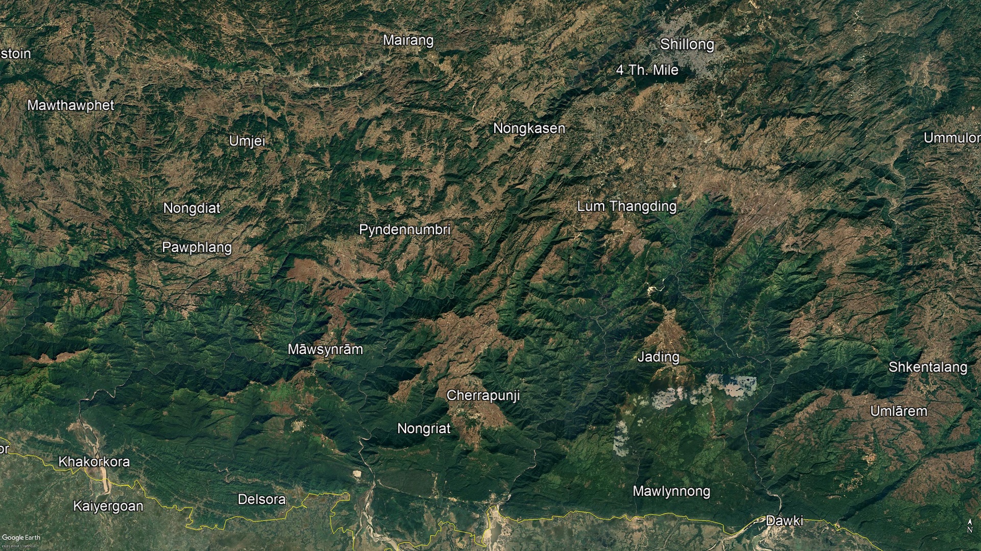
The grand canyons of Meghalaya are the focus of this book. To walk all the way across the Khasi Hills, I had to traverse the five deepest gorges found therein.
I began the trek at the riverside border town of Ranikor, which is at the western edge of the region where Khasis make up a significant part of the local population. From Ranikor, I walked east, through villages where forms of the Khasi language were spoken, until I reached a point where the prevailing tongue was a variant of the distinct (though related) Jaintia speech.
What this trek entailed was walking into and out of the immense gorges of the Kynshi, Umngi, Umiam, Umrew, and Umngot rivers. These gorges are not only deep and remote and often covered in thick vegetation; they are also unimaginably steep, in places dropping as much as eleven hundred meters over a mere 2.5-kilometer distance. The rugged landscapes of these canyonlands vary from the barren limestone moors at the edges of the valleys, to exposed rocky cliffs with dozens of waterfalls leaping from them, and then to misty jungles and the water-scraped beds of vigorous rivers. The interiors of the gorges are often only accessed by a combination of ancient stone stairways which take the shortest, and therefore steepest, routes possible between settlements, and faint, narrow, and frequently unreliable agricultural tracks.
There are whole worlds contained within these grand canyons of Meghalaya. While they are not densely populated, the valleys have been settled since time immemorial by the Khasi people. The gorges are thus dotted with remote villages which have their own distinct micro-cultures. In some valleys, groups of villages may have common histories, and speak nearly the same languages, but in others the languages might change drastically within the space of a few hours’ walk. Such is the difficulty of the landscape that in places a pair of villages separated by as little as a single ridge can almost seem to belong to two different ethnic groups. While modernity, with its roads and electricity and rapid communication, is imposing a sort of conformity on these little worlds, the canyonlands of southern Meghalaya remains a region of startling diversity, where a huge number of different kinds of people find themselves in cultural and geographical collision.
The gorges are therefore places in flux, which are full to the brim with conflict; of centuries-old rivalries between clans, smoldering, but not yet extinguished; of religious tension, brought about by the rapid conversion of the Khasis to Christianity from their primeval animist faith in only the past few generations; of ethnic insecurity caused by the proximity of the Khasis to Muslim and Hindu peoples from the plains; of arguments between the ancient traditional Khasi system of government and that imposed by the comparatively recent Indian state; and, finally, of the clash of the high-tech smart-phone and jet setting international tourism world of the 21st century with one that didn’t even have a written language two hundred years ago.
In the canyonlands of southern Meghalaya, an incredible landscape meets the fascinating and complex culture of the Khasis; a culture which, isolated in its stone fortress, has stamped its mark upon the hills and created a place like no other.
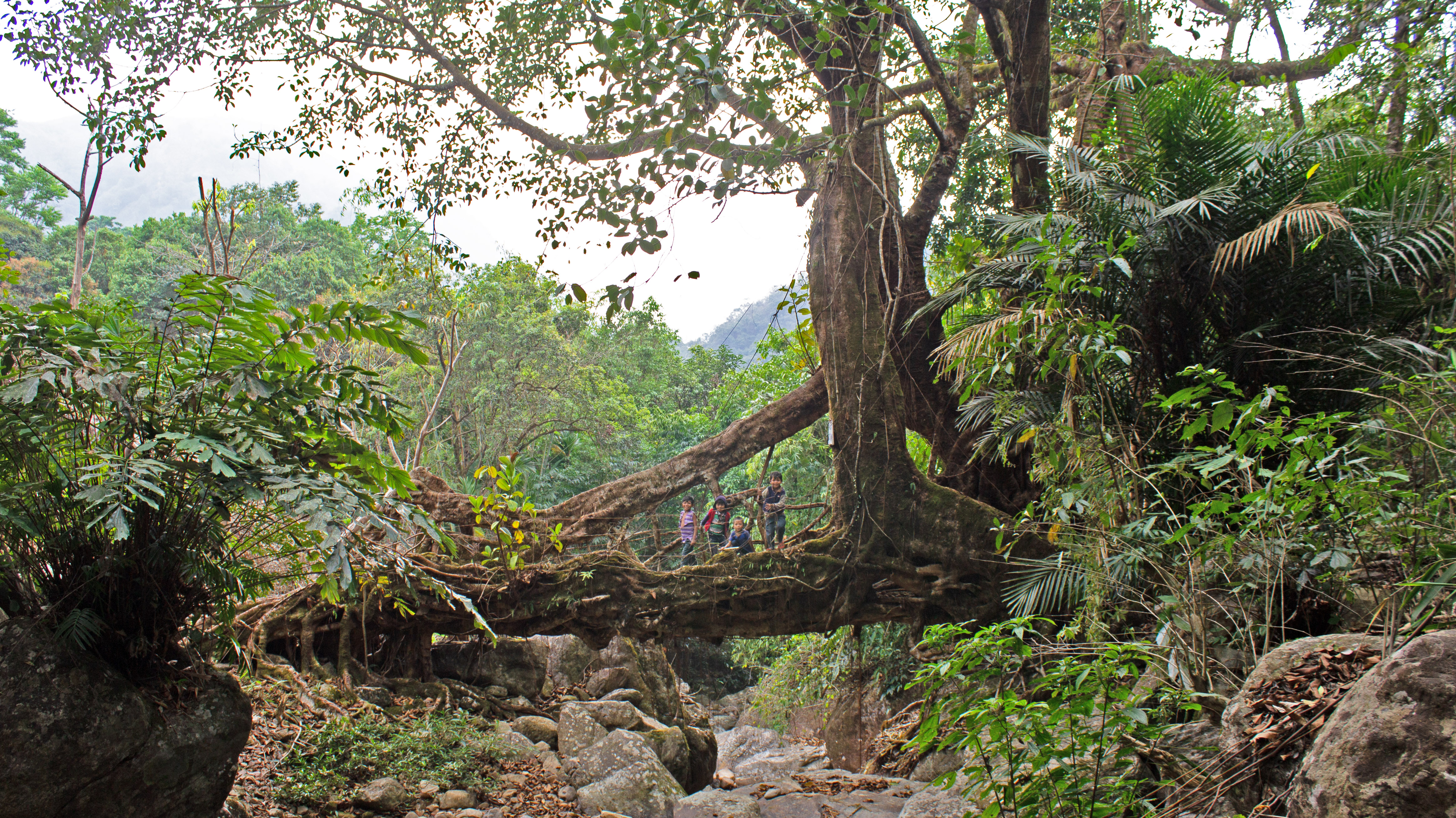
And yet, something which makes the Khasi people even more remarkable was virtually unknown to the outside world twenty years ago. As it turns out, dozens of villages in the Meghalaya canyonlands have generated useable, self-sustaining architecture out of the roots of the ficus elastica species of fig tree. The Khasis have built, or, rather, grown, living bridges that actively strengthen over time even when subjected to extreme humidity and the world’s most intense monsoonal precipitation.
While other ethnic groups, and even a few eccentric individuals, have created isolated examples of living architecture over the course of human history, what makes the Khasi practice so exceptional is its extent and its practicality. There are not simply a handful of root bridges scattered through Southern Meghalaya. Rather, there is an entire tradition of creating living architecture, practiced by thousands of people across dozens of villages, which has been handed down from a time well before the written word reached the Khasi Hills. The structures can be found over a huge area, and many Khasis still use root bridges in their day to day lives. Living architecture was first generated out of a spirit of hard-headed agricultural practicality: Khasis had to reach their crops during the monsoon season, when more traditional forms of infrastructure made from easily decomposing wood or bamboo were likely to fail. But the roots of living ficus elastica plants are naturally strong and weather resistant, and they can last for hundreds of years. The advantage of a root bridge is thus quite easily explained: if it’s alive, it won’t rot.
A living root bridge has no one engineer. There are no blueprints. The structures are brought into existence using the roots of the ficus elastica tree via a painstaking, often multi-generational, effort. The development and maintenance of a living bridge is a community endeavor in which the roots of the ficus plant are guided into the desired shape, sometimes over scaffoldings made of wood or bamboo, and sometimes simply by twisting and tying the individual strands together. It may take many years for a given root bridge to become operational (I’ve heard everything from three to thirty. The figure varies widely depending on local conditions), but even after the bridge is well established, it continues to grow and develop. Unlike any other form of architecture that I’m aware of, a root bridge is different each time you cross it.
This gives the living architecture of the Khasi Hills an otherworldly quality. A root bridge might begin as no more than a few thin strands stretched across a river, and then, centuries later, after all the original planters have died, the once wire-thin living span will have developed into a monumental structure that still serves the purpose of its long-deceased creators.
The fact that a root bridge is made by manipulating the natural growth process of a living organism means that each structure is unique. While there are certain commonalities when it comes to how the Khasi people have guided the various bridges into shape, no two living structures have developed in exactly the same way. This means that the sheer variety one encounters in root bridges is spectacular. Some can be crossed in a few strides; others extend over 50 meters from bank to bank. Some are simply a single long root that has been stretched as far as it will go; others are giant, complex, uncontrollable tangles of thousands of roots, where the growers seem to have simply given up trying to contain the organism. A new root bridge can consist of less than a dozen thin strands, each about the width of a piano-wire, which wobble at the slightest touch; an old one can have individual roots which, due to hundreds of years of growth and grafting, are over a meter thick and feel as hard as stone.
Sadly, the living architecture of the Khasi Hills is not as prevalent as it once was. In the past few decades, many root bridges have been replaced by far less distinctive and enduring steel and concrete structures, while other examples have been washed away in floods, fires, and landslides, and then not regrown. In large swathes of the Khasi Hills where living architecture was once common, the practice is now well on its way to going extinct. While the recent wave of interest in the phenomenon over the past ten years has sparked new calls for its conservation as a part of Khasi heritage, these efforts are still very much in their infancy. A few scattered root bridges, such as the twin-span “Double Decker” of Nongriat Village, are now world famous and have become icons of Meghalaya, but dozens of other examples which are just as beautiful and worth protecting are practically unknown.
There are fundamental questions about Khasi living architecture which remain unanswered. Nobody knows how far back root bridges go, or how the idea to create them first reached the hills; nobody knows how many there are, or even which village has made the most of them; nobody can say with any certainty which example is the oldest, longest, highest, etc.; and nobody has ever figured out why it was in the Khasi Hills, and seemingly nowhere else, that the practice of creating living architecture in large numbers took hold. Why aren’t there thousands of living bridges across Asia?
One of the reasons I walked all the way across the Khasi Hills was to do what little I could to address these gaping holes in the overall state of knowledge of the practice, if only as a complete amateur with almost no money and very little time. I had no hope of definitively answering any of the most interesting questions on the subject, but maybe by crossing the entire region where living root bridges were found and documenting the examples I encountered along the way, I could play a small part in their preservation.
But there’s much more to the Khasi Hills than living architecture. In the end, what truly makes a root bridge remarkable is the people who grew it. My other goal for the trek was thus to take a kind of snapshot of the hills as they appeared in early 2019; to go from village to village and valley to valley, talking to as many people and absorbing as much information as possible in the short amount of time that was available to me.
Every little corner of the grand canyons of the Khasi Hills contains fascinating traditional history, legends, and spiritual beliefs. Some of this folklore has been recorded, and there are a few scholarly works that one can access to get a general sense of the matter. Certainly, Khasi myths have been a subject of great interest to visitors to the hills for well over a century. Yet most Khasi folklore remains unwritten. It is passed on orally from one generation to the next; transmitted through time by memory alone. It exists as a kind of cloud that hangs over the hills, which is always there in the background, even if it has faded to a thin mist in the more cosmopolitan parts of the Khasi world. But in the deep jungle villages inside the gorges the cloud still forms a dense atmosphere. Even though interest in them has grown massively in the past few decades, little has ever been written about these remote villages. Likewise, there is still a great deal about the grand canyons of the Khasi Hills one can only learn by climbing down into them.
In short, walking all the way across the Khasi Hills would be more than worthwhile. But would it be possible? I was far from certain as I left my comfortable home in Newark, Delaware, U.S.A., for the canyonlands of southern Meghalaya in early 2019. Time was short. Money was scarce. The challenges ahead were immense. And they were unprecedented. I had never even heard of someone attempting a similar hike, at least not this century. But the trek I was contemplating wasn’t something I could afford to put off. It was impossible to say how long the window of opportunity would remain open. I was tempted to wait another year and save up a bit more funds so that I could spend a longer time walking. Of course, had I done so Covid-19 would have gotten in the way and this book wouldn’t exist.
Fortunately, I chose to bite the bullet in 2019, though at the time I didn’t view my chances of successfully completing the trek as especially high.
But it was worth a shot.
If you enjoyed this post, please consider supporting me on my Patreon page. There, you can download an extended edition of my book The Green Unknown which includes several chapters available exclusively on Patreon, as well as access a whole slew of other perks.

