
The next day was a long one. As I would soon find out, locals rarely travel all the way from Sohra to Ranikor in one go, though the only way for me to learn this was to try it.
Lengthy journeys using public transportation in Meghalaya present a series of challenges to face and hurdles to overcome. The vehicles are nearly always overcrowded. The roads, while they’ve improved over the years, are still often in poor condition. The city of Shillong, the transport hub of the whole eastern two thirds of Meghalaya and so the midpoint of virtually any road trip in the Khasi Hills, is usually a nightmare morass of bumper-to-bumper traffic. And even once you’ve reached the city, finding a public vehicle headed back out of town to the place you’re trying to get can be an iffy prospect.
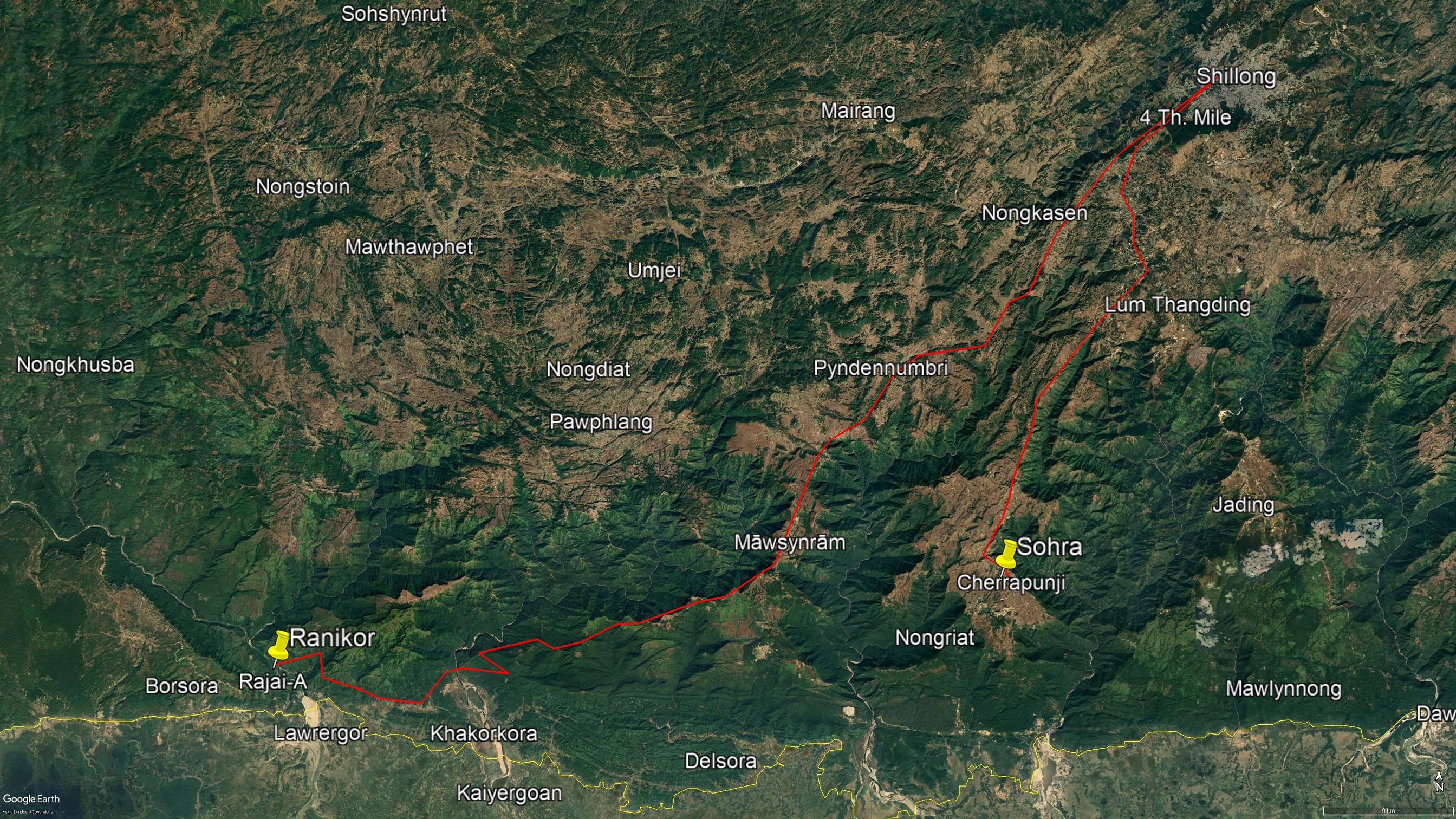
I had no idea on that February morning what the road conditions would be like after Shillong beyond a cursory view obtained from studying Google Earth. It didn’t look too far: In a straight-line, it was only about 75 kilometers from Shillong to Ranikor, a distance that would take no time to travel on the highways of my homeland. Of course, I wasn’t in my homeland.
The first step was to get from Sohra to Shillong. My plan for this part of the journey was to go to a small stand just down the road from By the Way and track down a locally popular kind of shared four-wheel drive vehicle called a Sumo. This would theoretically take me as far as another (vastly larger) stand in Shillong, where I hoped, though was by no means certain, that I’d find another Sumo headed towards Ranikor.
I went briefly back to By the Way, said goodbye to Heprit’s brother who was temporarily managing the place while Heprit was away, and then put on my heavy pack and started out.
Riding in crowded shared Sumos is perhaps the worst thing about travelling in Northeast India. In fact, one of the considerations that first led me to cover long distances on foot in Meghalaya was simply the desire to avoid public transportation. I stand strongly by the statement that a bad Sumo journey is tougher, both physically and psychologically, than your typical 10 KM hike.
Sumos are designed to seat about ten people. Thus, in the lax safety atmosphere of Meghalaya’s roads, you’re lucky if you’re only sharing one with fourteen other souls. What it means to be a “shared” Sumo is that the vehicle sits at a stand, and then people come and buy seats in it until the driver decides it’s full, whereupon he departs for a set destination. This, you might have guessed, gives the driver an incentive to fill the vehicle up absolutely as much as he can. As you might also have guessed, this is not safe. But for the driver, the calculus goes something like: Less safety=more passengers=more fares=more food on the table that night.
My experience has been that Sumos almost always fill up far too fast or far too slow. For a Phareng (which is the Khasi term for a Westerner), it’s a problem either way. In the case of the fast-filling examples, where the demand for the particular vehicle is high, a crowd of folks much larger than the carrying capacity of the Sumo will form around it and try to press in as quickly as possible. A Phareng in Meghalaya is automatically at a disadvantage at this point because Khasis tend to be quite small and therefore much better suited to maneuvering themselves into tight spaces. The Phareng’s predicament is only enhanced if they happen to be lugging around a giant cumbersome trekking bag which will either have to take up a whole seat or get stowed…somewhere. Sometimes, getting a seat just isn’t possible.
All of that said, despite the extreme inconvenience of Sumo travel, it does have a few massive advantages: It’s dirt cheap, and if you’re going someplace remote, it gets you there, albeit neither in comfort nor in style.
Two hours of uncomfortable waiting later, I departed Sohra in a Sumo designed to seat half as many souls as it was carrying, travelling due north up Highway 5 towards Shillong. To the right of the vehicle an immense valley plunged down about a thousand meters to the rocky course of the Sohra River, the opposite side of the gorge rising again in a long slope covered in pineapple plantations, patches of green jungle, and vast fields of a kind of grass which is harvested to make brooms. Through an inches-wide space of open window above my co-riders, I could just barely make out a tiny, thread-like trail on the further side of the valley. My intention was to walk that very trail in the weeks to come, but only after crossing a vast swathe of unknown territory to the west. As I rode packed like an imported white sardine in the middle of the Sumo, the day that I would be working my way up that distant path seemed almost infinitely remote.
The traffic along Highway 5 tends to be fairly light between Sohra and the outskirts of Shillong, though this changes for the worse once the rolling tableland begins to give way to increasingly dense urban development. Approaching the city from the south, as I was that morning, you’ll be lucky if the traffic hasn’t stalled by the time you reach the India Eastern Air Command Headquarters. From then on, the deeper into Shillong one gets, the slower one goes. Noxious fumes start to toxify the air outside. The city’s reputation as a cool, shady, hill station where one can get a respite from the heat of the Indian Summer starts to seem like a cruel joke, or at least false advertising.
As with most hill stations, the layout of Shillong was not set down with 21st century Indian middle-class vehicular tourism in mind. In fact, many of the city’s narrow mountain roads weren’t really designed for the combustion engine at all. But Shillong, serving as the largest hub of commerce, education, and tourism for the Khasi Hills (and also much of Northeast India), is roughly to the eastern two thirds of Meghalaya what Paris is to France. All roads lead there whether they can handle the traffic or not, and the result is not romantic.
It’s unfortunate that for anyone just passing through Shillong, all they get to see is pollution and the bumper of the car in front of them. There is much more to the city than this. Even in the congested 21st century, one can still happen upon lovely quiet neighborhoods, interesting markets, peaceful churches, and places on the fringes of town where the urban sprawl ends in a pleasant rolling countryside still blanketed in forests of the appropriately named Khasi Pine. If you want to see that side of Shillong, visit the North Eastern Hills University Campus. It’s absolutely lovely.
Now I was approaching what tends to be the worst part of any travel day in this part of the world: switching vehicles mid-journey. The Sumo was headed to Bara Bazaar, which contains Shillong’s primary long-distance taxi/Sumo/bus stand. It’s the filthy beating heart of transport in Meghalaya, a sea of vehicles crawling along at paces somewhere between glacial and tectonic, steered by anxious drivers and packed with uncomfortable passengers. It’s a prison of concrete and engines and wheels and trash and knock-off Chinese goods. Meghalaya’s full spectrum of ethnicities and identities, from Khasi fruit sellers and Garo truck drivers, to Marwari merchants and Naga university students, to Bangladeshi Muslims and turban-wearing Sikhs, to Catholic church groups and leathery Israeli backpackers, mixes here to create a muddy, angry, honking, stressed out soup of kaleidoscopic cultural vibrancy.
Bara Bazaar makes one want to leave Shillong as soon as possible. The problem is, the place is such a mess, one rarely can.
Blasting its horn through the chaos of Bara Bazaar, my Sumo neared its stopping point where it would park and then wait to fill up again with people heading back to Sohra. The rest of the passengers got out before the vehicle came to a full stop, having no reason to ride on to the end of the route. But since my giant backpack was up on the roof, I had to wait until the vehicle was parked to retrieve it. This meant spending a good long time crawling agonizingly through Bara Bazaar’s swamp of public transportation.
Sumos that make the Shillong to Sohra journey stop inside of a giant concrete parking structure as they wait for passengers. If there is any place in the world that can make one long to live a solitary and entirely natural life (preferably in the wastes of Siberia), it is this particular parking garage. Ill-lit, incredibly dirty, packed with tired, pissed off, impatient people, deafeningly loud with the constant echoes of dozens of vehicles honking their horns, the nightmarish Sohra Sumo stand really makes a person think twice when tempted to complain about airports.
Give me trackless jungle any day.
The Sumo climbed a dark ramp to the first floor of the parking structure, and then the driver maneuvered it up behind several Sohra-bound vehicles. Judging by the ant-like activity happening all-around them, the Sumos up ahead would soon be sufficiently dense with passengers to be deemed fit for departure. At this point my driver would move forward and collect his own horde of riders.
But first, the driver climbed up to the roof of the vehicle and handed down my giant trekking bag, laughing the moment he picked it up.
“Too heavy!” he said as he handed it down to me. “Like a whole house!”
“That’s the idea,” said I, taking the bag and putting it on my back. “Do you know where the Ranikor stand is?” I asked, hoping for a quick answer so that I could begin the next leg of the journey.
The driver thought a moment.
“Ranikor…Ranikor…Ranikor…” he repeated, his brow furrowed in contemplation. “Ranikor…Ranikor…Ranikor….” the driver trailed off wistfully. This was not encouraging. “Don’t know,” he said after a good long while, “You go all around here and ask anyone.”
This left me one option: to wander out into the eternal chaos of Bara Bazaar and accost random strangers for information. Usually, this strategy leads to a long frustrating process of being directed to ten places you didn’t need to be, only to find out that the vehicle you were looking for was right next to where you started.
Exiting the nightmare parking garage, I dodged pedestrians, taxis, scooters, busses, and livestock, looking for a likely person to approach. A tall mainland Indian guy was standing next to a bus, staring thoughtfully down at his smartphone. He had a knowledgeable face. Might as well give him a shot.
“Do you know where the Ranikor Sumo is?” I asked him.
“Ranikor?” he said, a bit surprised to be suddenly confronted with a foreign backpacker, but willing to help. “Wait.”
He walked off, disappearing into the chaos.
A few seconds later he reemerged with a lovely, beaming, lady Khasi traffic cop.
“Talk to her,” he said, and left.
“Ranikor!?” the cop shouted to me, laughing, amazed that anyone would be trying to go there if they didn’t absolutely have to.
“Yes mam!”
“I will show you the way!” she said as she gave me a friendly motion to follow her.
It was, I admit, a little embarrassing being led through Bara Bazaar by an authority figure, especially one half my size.
I had assumed that the Ranikor Sumo was nearby when the cop had decided to take time out from directing traffic, something which Bara Bazaar was in acute and constant need of, to show me where to go. But no. It turned out that the vehicle was in an entirely different parking structure some distance away. Thus, I unexpectedly found myself on the first real hike of my long journey.
As the lady cop and I walked forward, pedestrians and smaller vehicles dodged out of our way, while the cop brought others to a halt with hand signals and her whistle, in the process opening a corridor through the vehicular chaos like Moses parting the Red Sea. I didn’t think that I deserved such V.I.P. treatment, though it was nonetheless deeply appreciated. I just hoped that she’d get back on the job as soon as possible.
Once inside the next parking garage (which I’m happy to report was slightly airier and moderately less oppressive than the other one), the lady cop started inquiring around about the location of the Ranikor Sumo, proceeding hurriedly from vehicle to vehicle and asking driver after driver. We seemed to be in the right general area. All the automobiles around us were headed roughly to the southwest. But even here, Ranikor seemed to be a Sumo too far.
The lady cop was getting impatient. I don’t blame her. With the converging streams of vehicles from all over Meghalaya denied the benefit of her traffic management, I expected to see a mushroom cloud rising from the street outside at any second.
Luckily, it didn’t come to that.
Standing next to an old Sumo waaaay in the back of the garage that was beat up even by the high standards of Southern Meghalaya, the lady cop had a brief conversation with a thin, bespectacled fellow, and then turned to me, beaming.
“This is Ranikor!” she said, greatly relieved.
Then the fellow with the glasses, who I took to be the driver, interjected, and the lady’s smile faded, but only slightly.
“Oh! He says it does not leave for three hours. But this is the only Ranikor Sumo from Shillong today. Is it OK?” she asked, as though she was somehow responsible for this.
It was. Waiting for three hours would be a pain, but at least I knew where I needed to be.
The lady cop wanted to get back to her job, but, much to my surprise, right after she said goodbye, she pulled out her smartphone and took a selfie next to me.
Then she waved and ran off.
The three hours turned out to be a rough estimate. There was a lot of work to be done before the Sumo could depart.
A trip from Shillong to Ranikor is not like the ride I had taken from Sohra. This was clear just from looking at the dents and scrapes on the outside of the Sumo. At a distance, I had thought that the spiderweb of fissures on the windshield was just a popular sticker one sees in Northeast India, put there by drivers to make their vehicles look more rugged and hard-travelling and bad ass. But no. On closer inspection, I saw that on this Sumo the windshield was in fact broken.
However, what really gave away the vicissitudes of the road ahead was when the driver popped the hood. Everything inside the engine compartment was caked in a layer of clingy red dirt so thick I wondered how the Sumo could even start. This indicated that a large part of the journey would be unpaved and severely dusty.
The driver then went about replacing the spark plugs and installing new taillights right then and there. He didn’t bother to clean the vehicle, though. It was just going to get filthy again that evening.
While there are not many Sumos that run between Ranikor and Shillong, there are important goods which, in Meghalaya, can only be found in the big city. This means that the vehicles which do make the journey tend to be weighed down with a large part of the needs of an entire town.
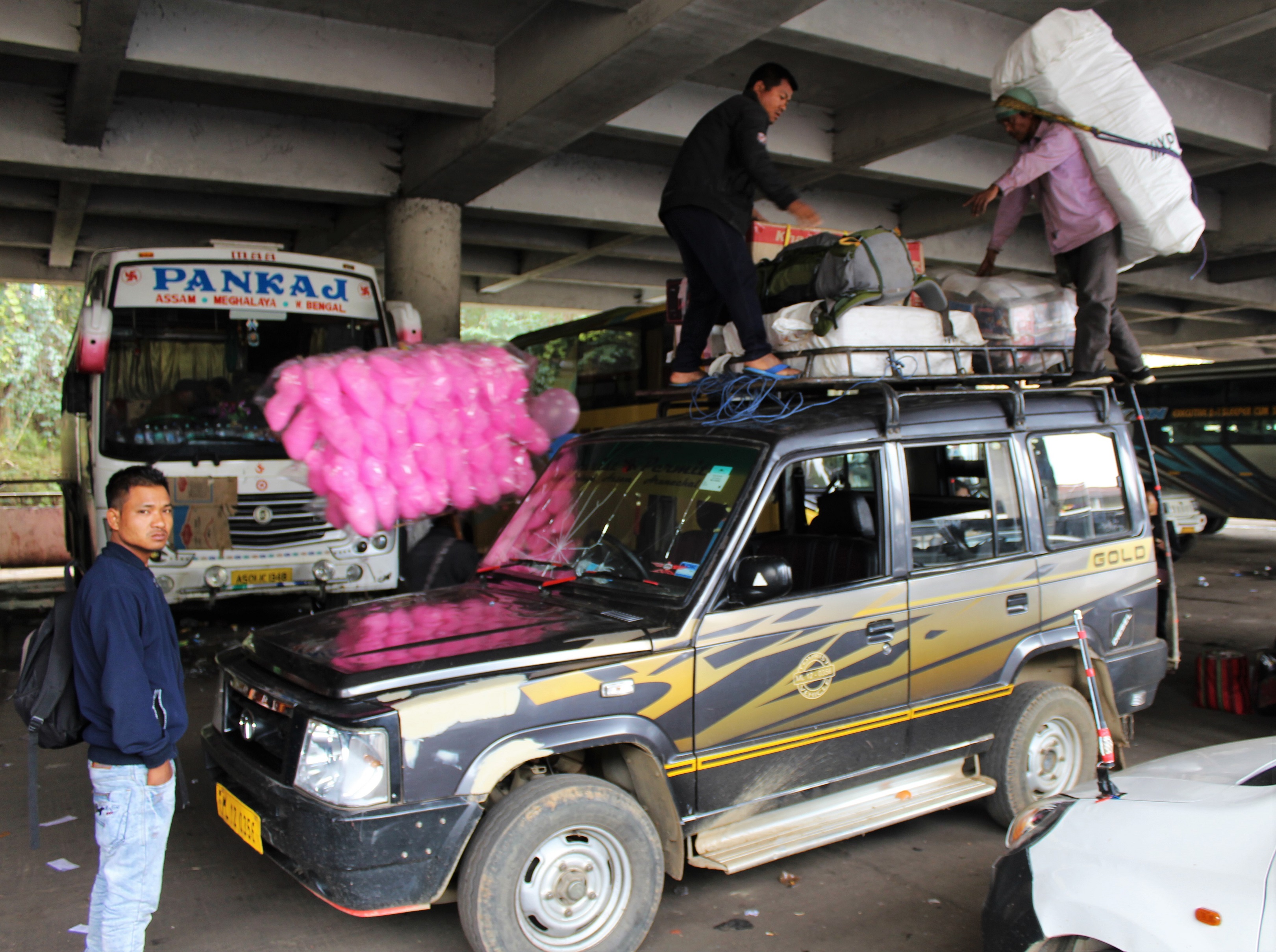
After the repairs were completed, the roof of the Sumo was loaded in a nerve-wracking three-dimensional game of Tetris. Numerous sacks of produce roughly the size of beached porpoises, half a dozen brown cardboard boxes of alcohol, and a plastic bag containing what must have been at least 50 pairs of shoes, were arranged on top of the vehicle and tied in place. My giant trekking bag was among the least of the big items that were Ranikor bound.
I doubt that there were many people in Bara Bazaar that day working harder than the two guys up on the roof of the Sumo. After several failed attempts, they managed to laboriously arrange the vast collection of freight into something like a Himalayan peak that, from the base of the packages to the summit, looked taller than the vehicle itself. An argument ensued between the guys on the roof and the bespectacled gentleman, who didn’t seem too keen on the prospect of driving for hours with a gigantic mound on top of his vehicle. Several times he made an angry lurching gesture, which I took to be him explaining that he thought the mountain of goods was likely to cause the Sumo to tip over once we got underway.
There was plenty of grumbling and bickering, but the driver won out in the end. The mountain was torn down. Then the driver demanded that several of the passengers split the cost of a few seats so that some of the luggage, including my trekking bag, could be stored inside instead of on the roof. That was fine with me.
There were quite a few people around the vehicle now, and with several of the seats inside bought up to store luggage, it looked like we were finally about to set out and leave the pollution and blaring horns of Bara Bazaar behind.
And then everybody went to lunch.
I sat at a tea stall near the Sumo for the next two hours as the day bled away. In the morning, I had been confident that I would be getting to Ranikor in daylight. That’s always a good thing when you’ve come to a new place, but especially when you don’t have any clear idea where you’re going to sleep or what sort of a reception you’re likely to get. But now my chances of arriving before sundown were fading with every passing minute.
When I asked the driver how long it would take to reach Ranikor, he responded: “Road is bad. Don’t know.”
That said, the mainland Indian style more-sugar-than-milk tea at the stall was mighty tasty.
I’d been staring blankly for a good long while into the chaos of the bazaar below, holding my third or fourth empty glass of tea, when the bespectacled driver came running up behind me yelling “Going! Going!”
Turning around, I saw that the Sumo had filled up with people behind my back, and they were all staring out the windows expectantly, waiting for me to get into the vehicle so that we could, finally, get moving.
I ran over and got in, taking a seat in the front so I could look out of the cracked windshield.
And then we were off.
Our journey started by pushing slowly out of town. As the concrete walls of the city gradually thinned, so too did the congestion around us. I began to feel that incredible sense of relief that only comes when you’ve been sitting around in traffic all day and then can, finally, speed up.
When we came to our turnoff towards the west, the highway was wide, well-paved, and marked by clean, newly erected signs with bright reflective letters showing the distances to far away cities such as Nongstoin, and even Tura, all the way on the other side of the state. The Sumo barreled down the smooth road at nearly 60kms per hour, an almost unheard-of speed for Southern Meghalaya. Maybe the road to Ranikor wasn’t going to be that rough after all.
A few minutes later the Sumo was descending a switchback where the surface of the road was so worn down and potholed that the rare mesas of surviving asphalt protruding out of the rutted dirt only served to make the journey bumpier and more nerve wracking. That brief stretch of wonderous blacktop had only persisted for a few kilometers.
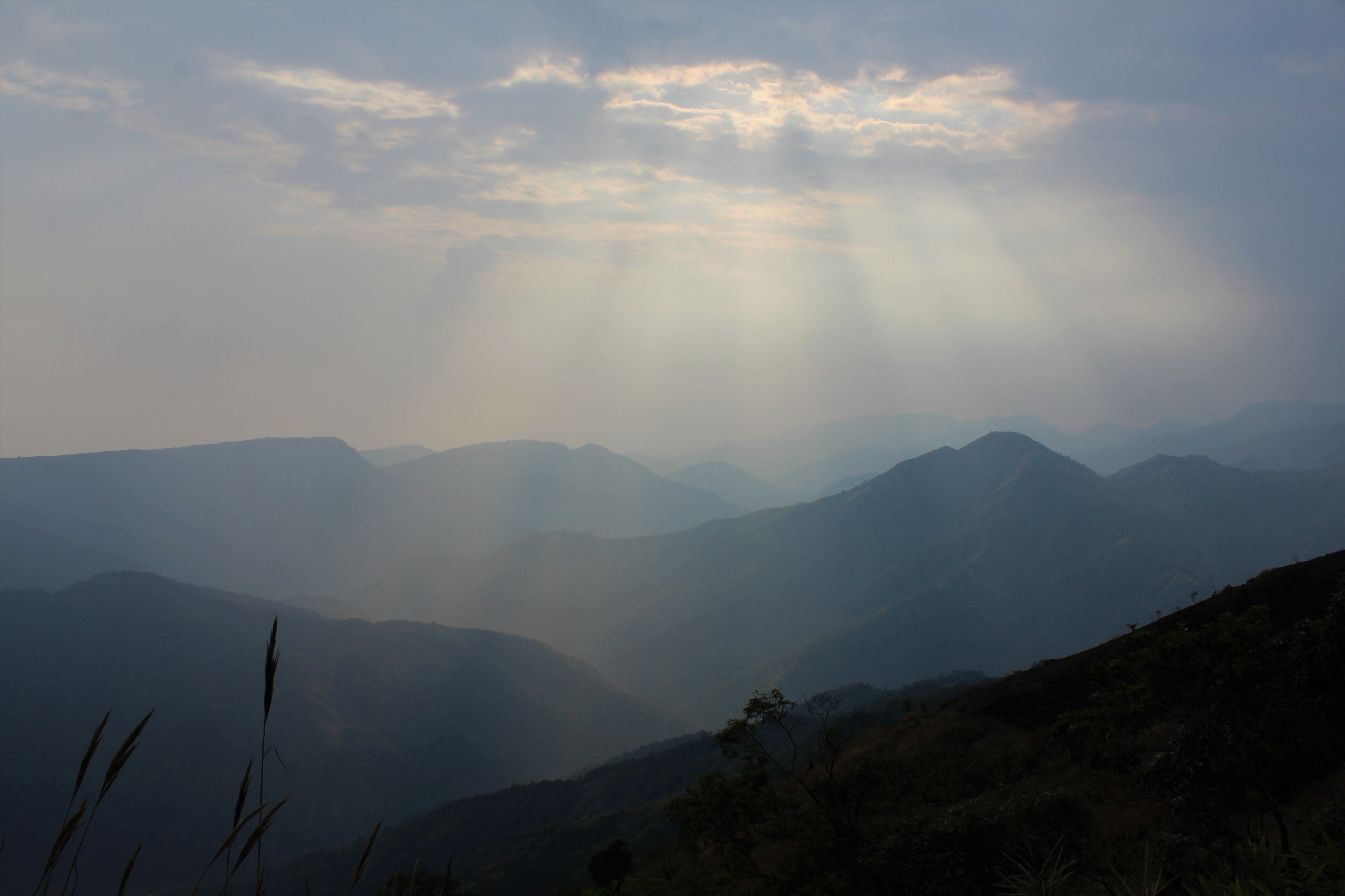
Our road took us roughly southwest, first through the picturesque village of Mawphlang, and then across a pretty high country of cool pine forests and paddy fields and modest hills. But as we pushed on, the ground began to fall away to the east in ever deepening valleys. Then the vehicle rounded a bend, and suddenly in front of us endless slopes plunged into the mist-filled gorge of the Umiam river. The sun was low in the sky, and the atmosphere was thick and smoky, so the great ridges were colorless in the evening light. The slopes seemed to merge into the deep fog as they descended, as though they were curtains hanging in the thick air.
The far side of the Umiam gorge, where I had begun the day’s journey, was only a dozen or so kilometers away in a straight line, but in that light it was invisible. From where I sat, the notion that it was even possible to walk across the endless gorge seemed absurd.
And then, shortly after the mid-sized town of Mawsynram, we rounded another bend and once again an infinite abyss opened up, but this time to the west. This was the complicated maze of terrain cut by the Umngi River, yet another vast system of dark jungle valleys that stretched far beyond the limits of what I could see through the mist.
Earlier in the day, working through the continuous stream of travel challenges Meghalaya had set in my path, there had been little time to ruminate on the sheer scale of the walk I was attempting. But now, sitting quietly in the front of the Ranikor bound Sumo, I finally had time to think. And that’s not always a good thing.
We were now on a thin isthmus of land suspended thousands of meters in the sky, with wholly separate, equally impenetrable, grand canyons to either side, both of which I had taken it upon myself to hike across over the coming weeks.
The task had never felt so monumentally unachievable.
Southwest of Mawsynram the Umngi valley takes a sudden turn to the west, the isthmus of high tableland curving around with it. I could look through the window to the left and see down well beyond the abrupt end of the Khasi Hills, all the way out over the incredible flatness of Bangladesh. With the evening well along, the sun was a great red ball of fire, exactly like on the Bangladeshi flag, not far above the orange and purple horizon. As we continued, the ridge steadily lowered, and gradually more fields, roads, and mostly dry watercourses could be made out below in the country next door.
The road clung to cliffs and followed along at the edges of great precipices, yet still the condition of the highway was surprisingly good, and we managed to keep up a decent pace of about 40 KMPH. Bangladesh was getting close now. The altitude of the road became low enough that increasingly dense patches of green jungle appeared to either side of it. The temperature went from the moderate high-altitude chill of Sohra and Shillong to a mild tropical evening.
Even if we weren’t exactly galloping along, we had to reach Ranikor soon. It was only 20 kilometers away.
And then the road ceased to exist.
We rounded a corner and drove into a solid, blinding, cloud of red dirt. All the windows were down, and dust rushed into the vehicle. Everyone scrambled to roll the windows back up, but it was too late. For the rest of the day I had grit in my mouth and a slight red discoloration. There must have been a truck in front of us somewhere. Not that we could see it. Or anything else. The dust in the air was so thick that the driver had to turn on his wipers to keep the glass from going black, while at the bottom of the cracked windshield an accumulation of several inches of red dirt piled up.
The road suddenly began to descend in tight switchbacks towards the border town of Balat and the River Umngi. This short stretch entirely made up for all the easy riding we had enjoyed up until this point. Our tires were digging deep into the soft surface of the road, while the vehicle occasionally slid from side to side, doing whatever the equivalent of hydroplaning in dirt is.
Yes, we were going downhill, which theoretically meant that we should have been picking up speed. The problem was that we couldn’t see anything. The driver stopped a few times to let the truck that was somewhere below us in the jungle get ahead, but that didn’t help much; once the truck was far enough in front of us for its cloud of dust to settle, another vehicle would come up from the opposite direction and throw more dirt into our windshield.
All the trees and bushes along the side of the road were caked in red, as was our Sumo, as were we.
Just by keeping his vehicle on the terrible road, the bespectacled driver was more than earning his pay. Down each dusty switch back, around every dirt-coated bend, the man deftly switched gears while dodging the huge, filthy, noisy, coal trucks which increasingly roared up from the opposite direction as the day faded. Only a true expert could have done what he did twice a day, several days a week, month after month, year after year.
The last few miles had been a slow, frustrating, crawl. But there was one place where the driver could go just as fast as he damn well pleased.
After yet more hard-scrabble downhill driving, we finally came to the banks of the Umngi. Spanning the river was a surprisingly wide and strong-looking concrete and metal bridge, about 200 meters long, with a beautifully paved surface. I’m not sure how such a lovely piece of infrastructure wound up servicing this otherwise dodgy route. Perhaps the thinking on the part of the engineers was that the Umngi crossing presented the weakest link when it came to connecting the western Khasi Hills with Mawsynram and Shillong, and so more funds were directed towards the construction and maintenance of the bridge than anywhere else along the road. After all, if the bridge had been out, the whole highway would have been rendered useless as far as the people living west of the Umngi were concerned, there being no other way for vehicles to get across the river between the Bangladesh border and well north of Mawsynram.
After kilometer upon kilometer of swimming through red dirt, the driver was determined to make some time. With a cloud of our own dust chasing us, we reached the eastern edge of the bridge. Then the driver stomped on the breaks, changed gears, and then hit the gas. The Sumo’s engine roared as we were launched across the Umngi. For all of half a minute we blazed along gloriously at 50 or 60 KMPH as cold, pure, dust-free air that flowed down from the high country with the river flooded the compartment.
Then we reached the other side and were back to crawling through the dirt.
After crossing the Umngi, we were subjected to more slow bumping along as the dusty road skirted the base of a huge massif of granite and limestone tableland off to our right. In that direction, well up the cool forested slopes, were many Khasi villages, several of which I planned to walk to in the coming days.
But the land that we now traversed at the bottom of the slope was a thin strip of geographical limbo that wasn’t really the Khasi Hills anymore, but wasn’t yet Bangladesh. We had come to the shore of Meghalaya’s cultural island, where the hills meet the plains. In some ways, this narrow ribbon of nowhere was as distinct from where I had begun the day as it was from my homeland. On either side of the road were men in lungis speaking Bengali, Hindu temples, mosques, lots of cows, and endless expanses of dry fields. The people living here spoke different languages, worshipped different gods, grew different crops, and had radically different histories than those who occupied the hills overlooking them.
As we rode through this corridor between worlds, I checked the time on my phone and had a momentary panic. It was suddenly much later than I thought it should be. Then I noticed that the phone had switched to international roaming. It had picked up a signal from the other side of the border, and had adjusted the clock for Bangladesh time, which is half an hour ahead of India.
I would later learn that this area is so remote and infrastructurally ill-served that the Indian citizens living there often don’t have access to Indian cell providers. They have to rely on Bangladeshi networks and smuggled sim cards to avoid paying exorbitant roaming fees just to talk to their neighbors. This has had the unintended consequence of creating a kind of unofficial, underground, time zone, where the people from the border areas are always thirty minutes ahead of the rest of the state.
The international border must have only been a few meters away to my left, though when I looked that way all I saw were dusty plains out to forever. Even though the road was still mostly unpaved, the land it traversed was flat, so the ride was faster and smoother than it had been back above the Umngi.
But now I saw things out of the window which made me wonder if I might get arrested before the night was out. Tall fences topped with mean coils of razor wire appeared on either side of the road. Every few minutes, the barriers would be interrupted by watch towers with searchlights and armed guards. Indian BSF (Border Security Force) vehicles sporting roof-mounted assault rifles patrolled the highway. Huge floodlights installed on nearby ridges shone into Bangladesh, illuminating large swathes of frontier-hugging fields along with a small, easily fordable river that flowed parallel to the road. On several occasions the Sumo was made to stop at check points, where guards would look at the driver’s papers and my passport.
The Indo-Bangla border is a strange place. In certain sectors, locals can move back and forth between countries with very little difficulty. When Partition cut Bangladesh (then East Pakistan), off from India, many of the ethnic groups in the area wound up with populations on either side of the divide. Khasis living within sight of Bangladesh frequently have relatives living there and illegally cross the border from time to time while the authorities in both countries turn a blind eye.
Still, the border is a national problem for India. Every year, huge numbers of Illegal immigrants fleeing Bangladesh cross it on their way to settle in Assam and other parts of the Northeast. Also, the more porous areas serve as conduits for narcotics smugglers and provide escape routes for ethnic insurgent outfits operating in and around the Garo Hills. In short, it’s not the sort of place to hang around after dark.
Judging from the map on my phone and the barriers I could see, in some places the small river separated the two countries, but in others, the highway itself constituted the border. The situation was so strange that Google Maps actually showed the road passing more than a hundred meters into Bangladesh at one point. This was a bit too close to the border for comfort. I would be glad when the highway curved right, and Bangladesh was a bit further away. Fortunately, when we were stopped at checkpoints, the border guards didn’t seem to think I was very suspicious. Apparently, I don’t look like a Bangladeshi illegal alien or Garo insurgent.
Night fell.
Slowly, with many twists and turns as the highway curved back north into the hills, we neared the valley of the broad and deep Ranikor River, which is known as the Kynshi further upstream. To our left was a wide stretch of eerily shimmering water lit by massive dystopian-looking floodlights which had been installed to discourage people from sneaking in and out of India on boats or by swimming, while ahead were many twinkling clusters of houses that climbed up the darkened eastern slope of the valley.
This was Ranikor. We made it.
If you enjoyed this post, please consider supporting me on my Patreon page. There, you can download an extended edition of my book The Green Unknown which includes several chapters available exclusively on Patreon, as well as access a whole slew of other perks.

