
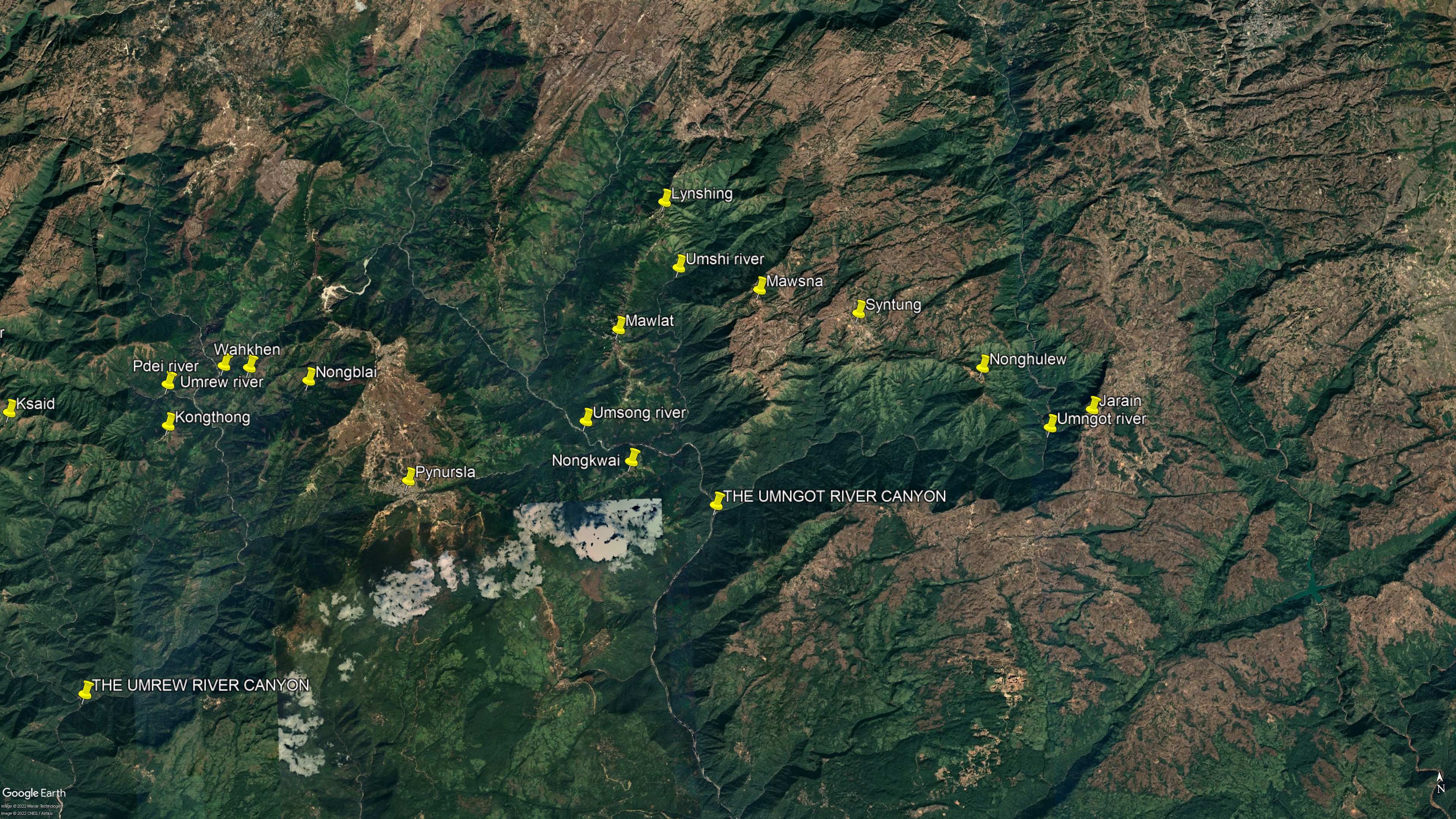
I stood at the top of a 600-meter stone stairway, thousands upon thousands of steps above the village of Nongkwai. Before me was the easternmost Grand Canyon of the Khasi Hills: the vast gorge of the mighty Umngot and its many tributaries. Fifteen kilometers to the east, through the white mist and over innumerable ridges and side canyons, the far rim of the gorge was just barely discernable. That faint line in the sky was about where Jarain should have been. There, the people would no longer speak the Khasi language. The end of the trek, the most difficult physical and mental challenge I had ever undertaken, was in sight. This was a bittersweet realization. Now that I had hiked across all the primary river systems of the Southern Khasi Hills but one, the days when the vast hidden gorges of this little corner of the world represented terra incognita to me were coming to a close.
The Umngot enters Bangladesh about twelve kilometers to the south of where I then stood, flowing into the neighboring country next to the border town of Dawki. Upstream from that culturally mixed settlement that straddles two nations, the Umngot cuts a long, crescent-shaped gorge that bends slightly to the northeast. There are a few significant tributaries of the river at this point, such as the Amkshar and Padu streams which flow into it from the east, though these only produce short, deep-but-narrow canyons, which are mere interruptions in the tableland rather than whole landscapes of their own.
The contrast between the lower and upper Umngot gorge couldn’t be greater. Not far below Nongkwai, the river makes an abrupt eastward turn and runs through an immense chasm for a few kilometers. Then it curves sharply to the north again and climbs to its cool headwaters atop the Shillong Plateau. To the west of the first sudden turn, several major tributaries merge and then meet the Umngot. These gouge a succession of huge, parallel, north-south running canyons. Several villages cling to the tops of the thin ridges that divide these gorges, and trails and very recently constructed roads lead along the crests. This makes for relatively easy trekking if one is intent on walking north to south. Heading west to east, I would learn soon enough, is a trickier proposition.
Other than simply crossing the region, my objective was to answer a major question I still had regarding Khasi living architecture: How far east was it to be found? Put another way: Were living root bridges as prevalent on this side of Pynursla as they were on the slopes to the west?
I had little data to go on. I knew that there were living root bridges to the south, closer to Dawki, particularly around the villages of Nongbareh, Kudeng Rim, Khonglah, and Padu, but as for the upper Umngot gorge, I had only received a single vague scrap of information. A few years before, as I was staying in a village called Burma, a relative of a friend told me that his relatives had crossed root bridges while they were growing up in a settlement called Lynshing. This information was, at best, sketchy, and possibly mistranslated (I’ve often found myself walking huge distances in the Khasi Hills in search of a misunderstood phrase). Still, the information was solid enough to make trekking to Lynshing at least worth doing. Even if the village turned out not to have any living architecture, there would be plenty of opportunities to pick up useful information along the way.
Lynshing is on a ridge north of Nongkwai, across the valley of a deep tributary of the Umngot called the Umsong. Getting to Lynshing from Nongkwai that day would not be possible. However, Google Maps indicated that there was a village just across the valley called Mawlat. That would be my goal for the night. When I reached Mawlat, I would ask around about the surrounding countryside, and begin feeling my way first to Lynshing, and then further east to Jarain and the end of the trek.
The night before, spent at my good friend Morningstar Kongthaw’s rest house in Rangthylliang Village, had been one of the best sleeps I’d gotten since I left Sohra, and that, combined with the positive effects of many weeks of intense exercise, helped me descend swiftly down the broom grass flanked steps to Nongkwai without so much as a twinge of stiffness in my legs.
Just as I was passing by the first houses, I happened upon a woman by the name of Rita, who informed me that, as far as she knew, a Phareng hadn’t been in the village for the last few years. The previous foreign visitor had been a Canadian who reportedly just stopped for tea and then moved on, though Rita hadn’t met him personally.
When I asked about the way to Mawlat, she was taken aback that I would wish to trek so far. She felt the settlement was much too distant for me to reach before sundown. Still, Rita explained that there was a route between the two villages: a path from Nongkwai descended all the way to the Umsong and then crossed it via an old metal bridge and led up to the top of the opposite slope. But according to her, this was a difficult path, even for a local. She wanted me to stay longer in Nongkwai. Spending a night was tempting. But Jarain was still far off.
After a very brief cup of tea at her house, Rita led me through Nongkwai to show me where the way down to the river began. The two of us reached the start of the trail to the Umsong, and it was with a note of uncertainty and regret that Rita bid me farewell as I put Nongkwai at my back and once again plunged down and down and down.
The character of the land below Nongkwai is quite different from that above it. The broom grass ends almost completely, replaced by a steep, stream-cleft emerald jungle. It was late afternoon now, and golden light slanted down into the forest as the air grew hotter and the view greener. The trail was the sort that, a few weeks before, would have left my knees wobbly and thighs rubbery in only a few minutes. Now I descended ever deeper into the valley with ease and passed through the spectacular jungle below Nongkwai almost too quickly.
Emerging from the jungle at the western end of a corroded old metal bridge, I found myself above the wide banks of one of the most remarkable rivers I’ve ever seen. This was the Umsong, where the water was as clear as air.
There were still a few hours left in the day. The afternoon was warm, and the stream looked tempting, even if it was likely to be bitterly cold. I hadn’t had a chance to take anything so much as resembling a bath since Nongblai, so I decided to have a swim.
After climbing down from the old concrete pylon that anchored the rusty bridge, I strolled over the river-polished stones towards the Umsong. And then my feet appeared to splash through the air itself. Shimmering white ripples spread out over the rocks like some sort of special effect. It took a second for my mind to process what my eyes were seeing. Then I noticed a tiny shrimp magically hovering above the stones.
The water was so pure that it was invisible.
Even with all the years I had spent trekking in the Khasi Hills, swimming in dozens of bodies of water across the region, the Umsong was clearer than I knew a river could be. When I first saw it from a distance, I judged it to be quite shallow. But then I conducted an experiment to gauge its depth. Taking a big round stone from the bank, I swam out to a great boulder that protruded from the surface. From the top of this, I could see clearly down to the riverbed, which I estimated to have been around three meters below. Then, after expelling all the air from my lungs, and still grasping the stone, I let myself slip off the side of the boulder. Down and down I went, the pure water rushing by, the temperature plummeting instantly from cool-but-bearable to hypothermic. Pressure built against my eardrums. And still I went deeper. My feet hadn’t touched the bottom when I let go of the rock and started groping my way back up to the surface. It was only after a few seconds that I heard the piercing crack of the stone against the riverbed. Then I burst back up into the air, with a new appreciation of just how deep the Umsong was…much more than three meters.
I considered setting up camp on the riverbank. In hindsight, this might have been a better decision than pressing on so late in the day. But for the first time since Sohra, I was feeling energetic, and so I crossed the corroded bridge and headed up the path on the other side of the river. This immediately shot up into the unknown jungle. Soon the shadow of night fell across the riverbed, now hundreds of meters below, and began to creep up the slope. I had no idea if I would make it to Mawlat. Likewise, I had no idea who, or what, I might encounter on the trail. And, with my GPS being inoperative and the path, as usual, being narrow and faint and twisting, I couldn’t even be sure if I was going in the right direction.
But by this point in the trek, I was used to all that.
If you enjoyed this post, please consider supporting me on my Patreon page. There, you can download an extended edition of my book The Green Unknown which includes several chapters available exclusively on Patreon, as well as access a whole slew of other perks.

