
The village of Wahkhen may be separated from Kongthong by a mere 3.5 kms in a straight line, but the path between the two settlements, a seldom traveled scratch through the hills, is a full day’s worth of difficult hiking. The track crosses a sheer-sided spur located at the angle formed by the confluence of the Pdei and Umrew rivers. The western bank of the Pdei is the boundary of Kongthong’s land. Starting at the opposite side of the river, the jungle belongs to Wahkhen. The walk between the two villages is first a descent to the rocky bed of the Pdei, followed by a steep ascent to the ridge of the spur, and then another descent to a bridge across the Umrew, and then a final, excruciating, climb up to Wahkhen itself. And those are just the broad strokes.
Behind the Kongthong Traveler’s Nest, a spider’s web of trails plunges through a wide sloping expanse of broom grass. Some of these paths converge on a single old stony trail that heads straight down to the Pdei; many don’t and quickly fade, leaving one stranded in the vast monotonous sea of Thysanolaena. Fortunately, I knew the area well enough to make educated guesses as to which were which.
Flanked by tall stocks of broom grass, I walked down and down into the Pdei valley. As I descended, the occasional distant name-song echoed through the hills, the sound reverberating from many different surfaces within the gorge. Soon the ridges had risen around me and blocked out most of the sky, while the Pdei grew louder until its song drowned out those of the people of the Katarshnong. Broom grass gave way to wild, thick, jungle, and the slopes became steeper and rockier. The sides of the valley cut off the sun, and the air grew much cooler. The Pdei originates in the chilly high country to the north, and though the weather had warmed up considerably since two nights before, at the high altitude where the river emerges from the ground it is still a frigid stream. Some of this chill is carried far down into the sweltering lowlands near Bangladesh, held in by the narrow confines of the area’s canyons.
Finally, I was able to make out blue stony pools through the vegetation below, along with sheer, white, canyon walls. In remarkably short order, I had descended over 600 meters, all the way to the bottom of the Pdei gorge.
The spot where the path crosses the Pdei is a remarkable place, where an incredible concentration of both manmade and natural beauty is packed into a tiny area. Here, within a few tens of meters of each other, are sheer walls of metamorphic rock; a scenic, if rapidly decomposing, metal bridge; several deep, clear, pools; two noisy and near-vertical tributaries that race down to the Pdei over white cascades; great, in all likelihood centuries-old, ficus elastica trees; along with an ancient living root bridge, a brand new one, and a living ladder. To go to that small place below Kongthong is to enter a microcosm of all that makes the jungles of the Khasi Hills worth visiting.

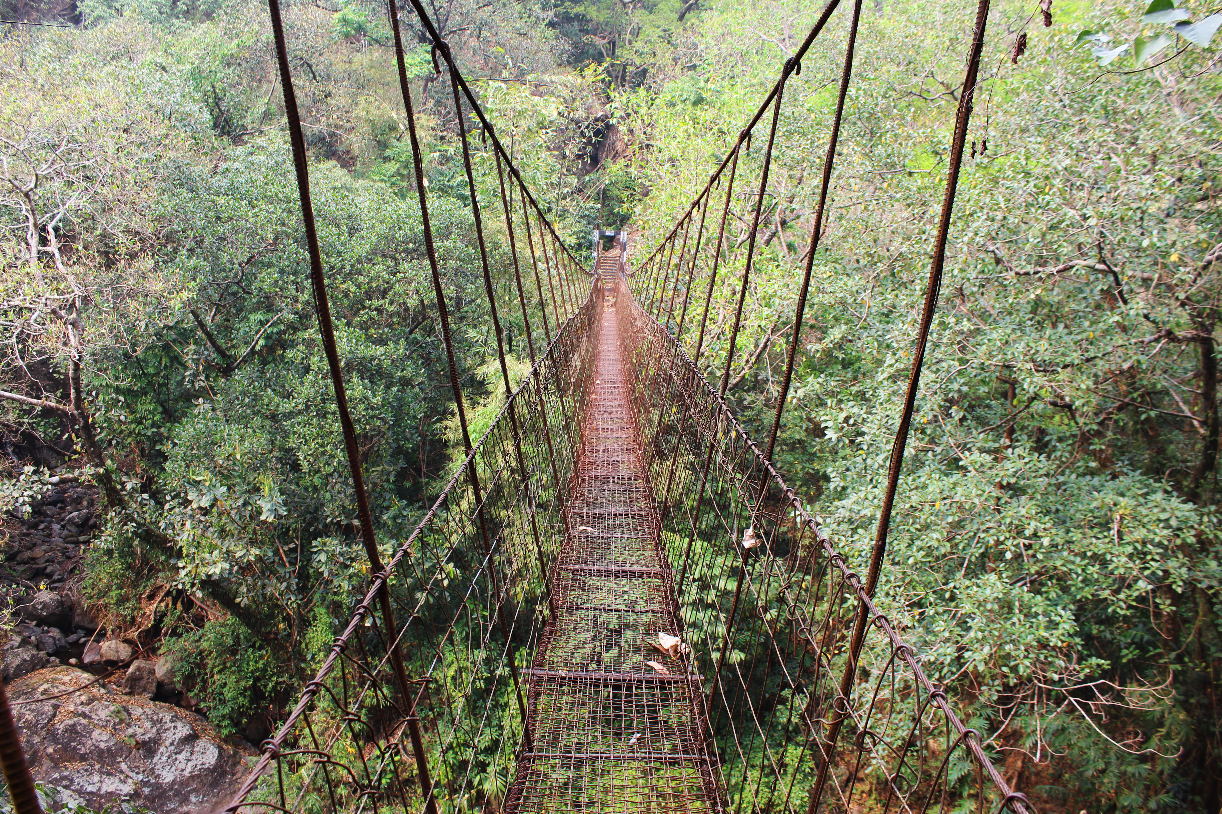
The trail down from Kongthong meets a metal bridge that hangs above the Pdei, high enough that when crossing the span one is afforded a view directly down onto the crowns of ficus elastica trees that have been planted along the sides of the river below.
I had been to the bridge before, back in 2015. Then, it had struck me as an unusually safe example of a deep-jungle metal span. Perhaps at that time it had been. The structure had only been strung across the gorge a few years before. It was a simple suspension bridge with four primary steel cables. An upper pair of cables was attached to the lower pair via a succession of bent Rebar rods, while a walkway was formed with large flat metal strips that spanned the space between the two lower cables. The metal strips left wide, dizzying gaps in the floor of the bridge, but in 2015 these openings had not been especially disconcerting: lots and lots of thin wires had been interwoven between the metal strips to form a perfectly adequate steel-mesh walkway.
But that was in 2015. The metal had since been left to corrode, year after year, monsoon after monsoon. In 2019, the primary structural elements of the bridge were still, seemingly, in good shape, but the thin metal wires had in many places rusted completely through. This left huge holes in the floor of the structure that one could easily fall through. To address this, the locals had placed bamboo poles across the gaps. But the poles had also been left in place for quite some time, making it a less than sure bet that they would hold if I placed my weight on them.
The worst stretch of the metal bridge was the part closest to the western wall of the canyon. Here, I had to take long steps over completely open spaces, from thin metal strip to thin metal strip. Fortunately, the span was in better condition in the middle and on the eastern side, though I was still relieved to be on the other end of it.
The metal bridge deposited me on a rocky shelf overlooking the Pdei. To the left there was a tall chute naturally carved into the side of the canyon where a thin white cascade poured down from the high country. Directly ahead was a stone wall, six or seven meters high, over which trickled another small stream. The flowing water resulted in the escarpment being covered in wet moss and hardy vines and ferns. Due to the restrictive nature of the terrain, the original builders of the path between Kongthong and Wahkhen had no option but to somehow lead the trail over this parapet, so they chose the most practical option available to them: to grow a living ladder at the spot.
A ficus elastica tree was planted at the top of the wall, and its roots were encouraged to grow down the stone in a sloping configuration. During the drier parts of the year, the stream that flows parallel to the ladder is little more than a slow drip over the stone. But, judging by the smoothed and scoured appearance of the rock, in the wet season the stream’s flow increases a hundred-fold and the stone wall becomes a waterfall. During the yearly deluges, the unassuming piece of living architecture becomes a cross between a ladder and bridge that must withstand an incredible force of water pouring down from above. And if the structure fails, the precarious link between Kongthong and Wahkhen will be severed.
Right after climbing the living ladder, I was greeted by another wonder of botanical engineering. Crossing the same stream as it flowed through a valley about a minutes’ walk up from the stone wall was a huge, weirdly sloping structure, again somewhere between a living bridge and a living ladder. Bizarrely, much of the tree the structure was formed from had somehow become suspended high up on thick, post-like roots. The larger branches radiated out of a dense tangled cluster of growth well above the riverbed, from which the primary span of the bridge sloped down to the northern bank of the stream, while oddly thin roots extended over the short distance from the tangle to the southern bank.
From certain angles the structure didn’t even resemble a bridge, and there wasn’t a discernible trail on the other side of it. Yet the solid sloping roots that allowed the tree to extend from one side of the little river to the other had most definitely been pulled, twisted, and encouraged to merge. As odd as the living structure was, it was definitely architectural, even if it looked rather more like something out of an H.R. Giger illustration than what most people think of when they imagine a living root bridge.
It seems unlikely that the current configuration of the bridge was what the original planters had in mind. The severe slope of the walkway makes crossing the structure a difficult climb. This suggests to me that the bridge may be a very old example, one which has survived even as the land around it has shifted over the centuries and the inherent growth of the organism has warped the structure into an eccentric, unanticipated, shape.
On closer inspection, several clues emerged which pointed to the structure being older than the vast majority of the living bridges I’ve visited over the years. One thing that immediately set it apart were the several great aerial roots that plunged straight down from the middle of the span and held the structure above the riverbed. This was unusual. Most root bridges, even very long ones, do not have piers. But here, some of the living piers were as thick as trees in their own right, and they were firmly anchored to the rocks below. This indicated that they had been in existence for quite some time. Yet, all the growth of the living piers must have occurred after the primary span had been sent across and growing for years.
When one climbs up onto the H.R. Giger bridge, the first thing that you’ll notice is that there isn’t any play in the roots whatsoever, another sign that the bridge is no recent addition to the landscape. The next thing you’re likely to take note of is just how odd, from a functional standpoint, the bridge is. Why, if the purpose of the bridge is to cross a stream, would the span of the structure slope steeply upwards, reach a sort of peak above the middle of the river, and then slope down to the other side?
I suspect that the answer lies in the living bridge being much older than most. When one gets to the tangle of roots and branches at the high point of the span, a series of much thinner, more recent, roots extend to the opposite bank of the river. It seems likely that these new strands were guided into place after the bridge was well established, but the bank had somehow receded. Likewise, the slope of the bridge may be due, at least in part, to the southern bank of the river having subsided after the strong aerial-root/support pillars in the center of the structure were already in place, meaning that even as the southern end of the bridge’s span was lowered in elevation, the center was still held aloft.
Maybe the reason the structure is so oddly and counterintuitively laid out is that it survived even after the landscape it had been designed to ease passage through changed substantially over the decades and centuries.

Just upstream from the H.R. Geiger bridge is yet another living structure. But this one, I feel certain, has not been alive long. The ficus elastica it is formed from is small, and the bridge itself is primarily composed of a single root only a few inches thick. As a tiny and not particularly visually distinctive example, the structure would not be of much interest were it not for the fact that I had been able to observe it develop over the course of nearly half a decade.
I had taken note of the new living bridge all the way back in 2015. At that time, it was small and virtually impossible to cross since there was no way to balance oneself while walking over the inches-thin span. But when I returned in 2016, a set of bamboo railings had been added, which also served as scaffoldings along which many very thin ficus elastica roots had been wound, though these were not yet strong enough to place much weight upon. The bridge was still difficult to cross, but it had nonetheless grown substantially.
Now, as I came to the bridge for the third time, it had developed so much that it was nearly unrecognizable. The bamboo railings were gone, replaced by a network of intertwined roots. While most of these were still thin, they had grown enough that they provided a useable railing on either side of the span. In addition to these, many thread-like areal roots had been recently strung down from the branches of the ficus elastica tree above, providing additional stability to the structure.
While it may be true that it takes a long time for a living bridge to go from initial planting to complete functionality, this does not mean that their rate of development is slow. Ficus elastica trees tend to naturally be in a relentless state of growth and adaptation. They are constantly shooting out additional roots and grasping onto new surfaces. That living bridges are evolving structures is one of the things which make revisiting them interesting, and which sets them apart from virtually any other sort of historical or traditional architecture. Though living root bridges can be decades or even centuries old, it’s impossible to cross the same one twice.

It was all unfamiliar territory beyond the new bridge. And this, I learned soon enough, was bad territory to be unfamiliar with. Upstream from the three pieces of living architecture, the little river bifurcated several times. Numerous small valleys and crevices intersected the path as it followed the shifting watercourses. The jungle was dark and thick, full of ferns and palms and impenetrable thorny undergrowth, with few signs of cultivation.
There were no more name-songs in the ether. The green defiles were quiet but for the sounds of the little streams that trickled through them. After the valleys of loving tunes that floated in on the wind from every direction, this new rugged jungle seemed lonesome and threatening. Perhaps it was a Sacred Forest, and I shouldn’t have been there at all.
To add to my unease, the path was narrowing. Spiderwebs appeared across it. And then the trail, like the stream, bifurcated into two rough tracks. I took what looked like the more likely route…and found that this, too, soon divided. The underbrush was closing in. The greenery was becoming thicker and thornier. The stream had turned into a muddy marsh with tiny rills flowing under fallen leaves. Then the path faded completely.
This was bad. I tried to use the GPS on my phone to get a reading. No luck. Stuck in a valley, in the bottom of a gorge, which was itself only one minor corridor in an immense labyrinth of many canyons, I had come to one of the last places in the world shielded from space, where GPS truly does not work.
Or perhaps I really had offended the spirits, and they were actively blocking GPS in their sacred forest.
At this point it was clear that I had either taken a wrong turn, or that the path between Kongthong and Wahkhen was the sort of trek that one simply has to take with a local who is intimately familiar with every rock and stream and tree on their village land. The riverbed, now just a muddy rut, had gradually, imperceptibly, become my trail. Then the rut promptly disappeared into the undergrowth in the side of a u-shaped saddle between two hills.
I’ve trekked enough in my life to know when I’m beaten. If I left the watercourse, I’d have no bearings. Pushing on through the undergrowth would likely get me totally lost.
I was getting low on water. Fortunately, a hollowed-out bamboo pole had been stuck into the slope at the side of the little valley. A tiny drip trickled out of the end of the tube; so tiny that I had to hold my bottle under the bamboo for close to ten minutes to fill the container. But it was worth the wait. The water was so cold that condensation formed on the outside of the bottle, while inside there was not so much as a single mote of dirt. It tasted wonderful, and at the time seemed like a bit of a consolation for what was shaping up to be a failed day’s trek.
And then, both silently and shockingly, two cupped together hands reached out of the underbrush in front of me and were brought under the dripping water. I gave a start, shattering the eerie silence of the valley.
There, in the brush next to the bamboo pole, was a shirtless old man. He had approached hobbit-like down the verdure covered slope without making a sound. Though the man sheepishly refused to make eye-contact, he looked about as surprised to see me as I was to see him.
“Howdy,” said I.
Without looking me in the face, the man brought the cupped water to his lips.
Then I noticed something moving along the slope behind him: a whole extended family gliding silently through the jungle. Men, women, and, of course, many children, floated through the undergrowth up the hill. I’m not sure why they were being so quiet. Perhaps we really were in a Sacred Forest.
These folks were not as friendly as many of the people I had met in the hills, and I got the impression that they found my presence rather surprising and off-putting. As they came closer, still up on the ridge above the stream, I heard scared whispers among the children, though they were immediately hushed by the adults, who would furtively glance my way every few steps as they walked along.
Still, despite their timidity, these people had done me a service. They appeared to be on a trail. I turned back to the man.
“Wahkhen?” I asked.
He grunted, and then traced the ridge the others were walking along with an outstretched hand, indicating that this was where the path lay.
I thanked him, and then climbed up the slope. Soon I came to a well-beaten route along the crest of the ridge. I’m not sure how I had gotten lost, but thanks to the silent wanderers I was back on track.
I wonder where they were going.
The way forward now led up and around the southern edge of the great green peninsula formed by the meeting of the Pdei and Umrew Rivers. The jungle once again gave way to broom grass, just as the path started to descend again towards the Umrew. The trail, though ancient and far from any major settlement, was nonetheless wide and manifestly well-travelled.
As the path led me down into the cool valley of the Umrew, the jungle closed in once more, though still the way remained clear. If anything, it was getting increasingly well-maintained, almost as though it was about to lead into a village. However, a brief look at the cached Google Maps images I had stored on my phone did not show one anywhere nearby.
But as I walked on, a steadily increasing number of side paths came down from the slope above or up from the valley below. Jackfruit and Areca palms appeared next to the trail, having clearly been recently planted there. Then I saw a grey wall through the trees: the corrugated metal side of a house. The structure had a thatch roof and a bamboo floor raised on stilts. Walking a bit further, I saw that I had come to a cluster of four little jungle huts. There were no power lines leading down to them, though they did have running water courtesy of a small spring in the side of the hill above. All around were bamboo clothes lines hung with rough garments, evidence that people were currently living here. Interspersed through the small patch of cleared jungle around the houses were freshly planted Areca Palms that were shorter than your typical Khasi adult, several papaya trees, young banana plants, along with some venerable looking Jackfruit which likely predated the buildings. As for the inhabitants of the houses, they didn’t appear to be in.
I learned over the course of the subsequent days that this was another agricultural colony, a single extended family from Wahkhen having built the houses themselves, though they only occupied the settlement for a part of the year to harvest their deep jungle crops.
Given that they appear so close on a map, one would think that Wahkhen is an easy stroll from its little jungle colony. However, the path between the two settlements goes through some of the very most rugged parts of the Umrew gorge, gaining hundreds of meters between the riverbed and the lowest houses of the village. Even for someone unburdened but in good shape, this is a hard walk. For the people of the little four-house settlement, who regularly carry large sacks of produce on their backs that weigh in excess of 50kgs up to Wahkhen, this must be excruciating toil (though, on the bright side, they’ll never have to worry about obesity).
The people who lived in the little jungle colony, the last outpost of Wahkhen village, existed at the frontier of Khasi society. For many wild kilometers to the north, back into the forgotten folds of the upper Umrew Gorge, there are no major settlements, just jungles and steep ridges and valleys.
Yet Wahkhen itself is not exactly cosmopolitan. All the villages of southern Meghalaya are set precariously on a cliff at the very edge of India, looking out over Bangladesh; just like the whole of the Northeast is left dangling out on the furthest geographical extremities of the country, no longer quite South Asia, but not yet Southeast Asia either. The four-house colony in the jungle was the metaphorical ends of the earth clinging precariously to the literal ends of the earth.
Maybe, over time, the little family in the jungle will grow, and more people will move into the colony. Perhaps electricity will one day reach down to it. Maybe the settlement will eventually break away from Wahkhen and become its own self-governing entity, so that in a few decades there will be a whole new village on the rugged peninsula between the Pdei and the Umrew, with its own churches and schools and community halls, where children are born and raised, and where husbands move to when they get married.
Who knows, maybe they’ll even have a road.

Now the trail descended to the Umrew proper, which here poured over a broad, rocky bed, and was crossed by another steel bridge. I decided to rest for a minute or two in the center of the metal span, enjoying the cool wind that descended along the river. Though I had come to the very lowest part of the Umrew canyon, the width of the river meant that there was a substantial clearing in the jungle, through which I was able to see a wide swath of open sky, along with much of the rough, stony, country that hems in the very bottom of the gorge.
Here, the jungle clings to the roots of vast black outcroppings, sheer-faced like fortresses. Great dark fangs of stone shoot up into the sky, their upper altitudes too sheer for growth to find purchase. At this point in its course, the Umrew cleaves through a large section of the deeper, harder, rock that underlays the Khasi Hills, which is usually hidden under thick layers of limestone, sandstone, mixtures of fallen debris composed of both of those materials, or, most often, green jungle. I’m told that these remote stone castles are among the last strongholds of many of the larger mammals that once widely inhabited the region; that they are some of the final large tracts of territory in the Umrew gorge that are truly inaccessible, even to determined Khasi hunters.
The sun was now below the western wall of the gorge, its golden light becoming darker and redder as it crept up the sides of the ridges and outcroppings. It was time to push on. I reached the other end of the bridge, and the path immediately shot straight up the southern side of the valley.
It only occurred to me then that of the five great rivers I had to trek across to walk from Ranikor to Jarain, four were now behind me. While Jarain might have still been far off, and the land beyond Pynursla completely unknown, the end of the trek was fast approaching. There was just one more great river to cross.
The climb to Wahkhen was a slow trudge, straight up, step by step, meter by meter, through bamboo thickets and jackfruit plantations and over exposed black outcroppings. I stumbled into the village soaked with sweat and thoroughly exhausted.
After a great deal of additional stumbling, I managed to get permission to spend the night in Wahkhen, not from the headman, but from his brother, who was also a village teacher. He possessed the keys to a small storeroom attached to the village’s surprisingly large school campus, and he informed me that, if I didn’t mind cramped quarters and curious kids first thing in the morning, I could sleep there.
The storeroom was a free-standing building which had become a depot for government food aid rations. Much of the floor space was taken up by giant bags of rice. There was barely room to stand, barely room to lay down, but once I hit the floor, I was asleep in seconds.
If you enjoyed this post, please consider supporting me on my Patreon page. There, you can download an extended edition of my book The Green Unknown which includes several chapters available exclusively on Patreon, as well as access a whole slew of other perks.

