
Dawn comes extremely early in Northeast India. This is because the whole country falls within the same time zone, which is convenient for the majority of the Indian population who are concentrated in the North-Central part of the subcontinent. But for the people living way out on the eastern fringes of the nation, Indian Standard Time is just another reminder of how far they are from the mainstream.
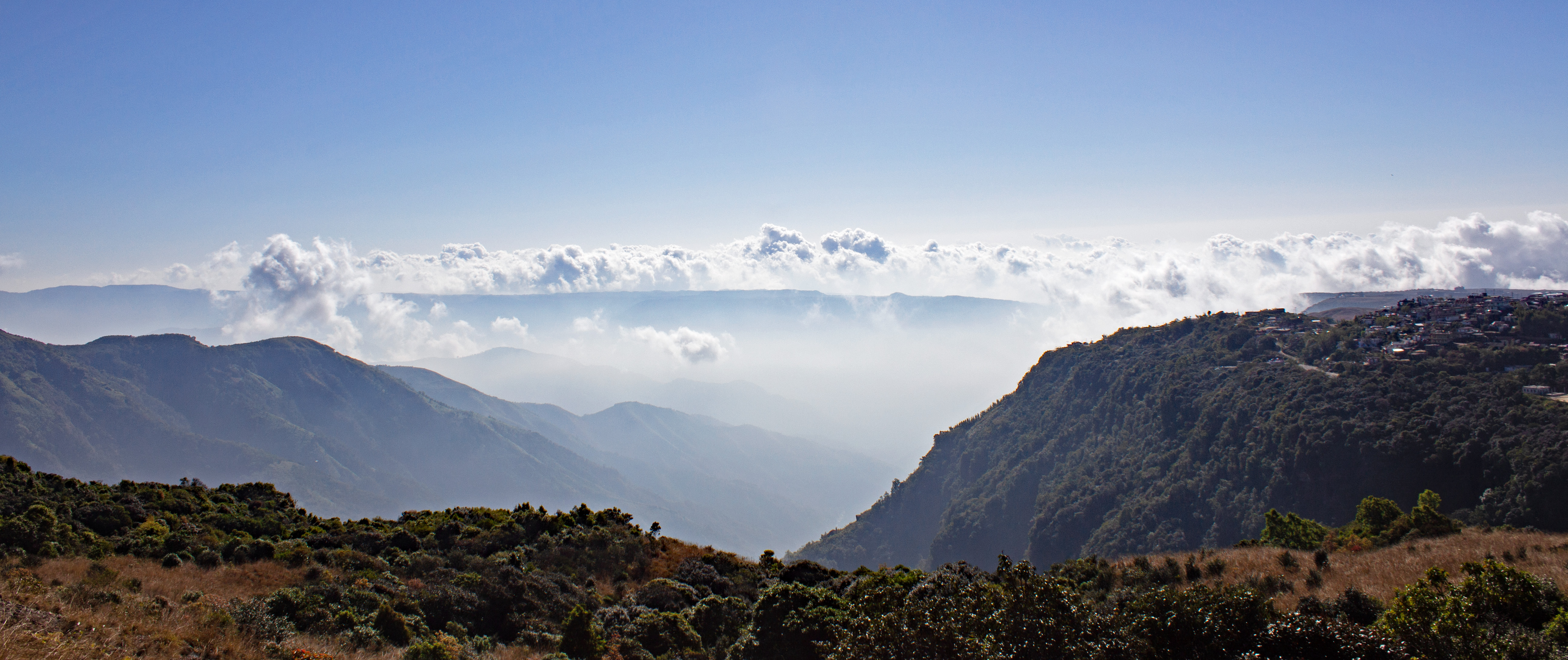
The sun was well above the horizon by five a.m. that morning. A crisp, clear, air mass had settled over the hills. I could look east and see completely across the next great valley. On the other side tiny villages, roads, and trails, were sharply visible in the refreshingly transparent atmosphere. Before the trek, when I gazed out over the same vista clouded with dust and the smoke of agricultural fires, the idea of walking across the valley had seemed almost absurd. Now, on a bright morning perfect for trekking and after days of rest, the other side appeared almost close, like I could make it there in a single afternoon.
Had I never walked in the valley, I might have believed that. But I knew better.
The task at hand was to traverse the vast canyon system of the Umrew river, a maze of valleys and gorges that separates the high tableland around Sohra from that around the similar-sized town of Pynursla.
The Umrew basin contains perhaps the most convoluted terrain in all the Khasi Hills. Unlike the other grand canyons of Southern Meghalaya, which tend to settle into their primary channels well north of Bangladesh, the Umrew basin is a labyrinthine collection of numerous significant tributaries, all of them excavating their own canyon systems, which results in topography that is almost fractal in its complexity. It is south of Sohra, a mere seven or eight kilometers from the Bangladesh border, that the streams feeding the Umrew meet the larger river, only then revealing it to be the primary drainage in the region.
In the wide space between the plateaus crowned by Sohra and Pynursla are many ridges, none of which are quite so brutal as the slopes that hem in the Umiam valley, though what they lack in steepness (and bear in mind that they would be considered tremendously steep in virtually any other part of the world) they make up for in sheer numbers. In the Umrew basin, one is never descending long before one begins to ascend again.

This extreme ruggedness has kept many of the area’s villages more cut off from modern life than those in other parts of Meghalaya. Christianity is not quite so dominant in the Umrew basin as it is elsewhere in the Khasi hills, even though it, like the area’s roads, is advancing to ever more isolated settlements. But in villages such as Kongthong, Wahkhen, and the even more remote hamlets that surround them, the old animistic ways are still going strong.
Yet, despite the Umrew basin’s rugged isolation, there were parts of it that were familiar. I had been to the hills around Kongthong village twice before and knew them well enough to traverse unguided. But these were roughly in the center of the Umrew gorge. The flanks of the labyrinth of hills and valleys were large swathes of territory that were still terra incognita for me.
On the western side of the basin was the sudden gorge of the Sohra river. Riding south down Highway 5 from Shillong to Sohra, this is what one looks out over when the Shillong Plateau drops away and the canyon country first opens up before you. That vista, now overlooked by an official tourist stop christened the Mawkdok Dympep Valley Viewpoint, attracts hordes of visitors rushing to the usual list of scenic attractions in Sohra. But almost none of them actually venture into the gorge. And before 2019, neither had I.
Crossing the valley of the Sohra river would be the core of the day’s mission. My objective was to reach a village called Kshaid, which I had a vague notion was somewhere on the eastern slope of the gorge. I had been told in 2015 that there was a living root bridge near the village, but at the time hadn’t been able to confirm this. But now I hoped to reach Kshaid and spend some time reconnoitering.
Getting to Kshaid that day would entail walking north up Highway 5 for a modest distance of 12 kms. Then I would turn right at a large football field where Google Earth imagery revealed the start of a wide trail that led down into the Sohra river valley. If I could reach the field, I could probably reach the river, and the satellite imagery showed a fair number of trails leading up to the top of the ridge on the other side.
But even if I got that far, it would still leave a final challenge: ascertaining where Kshaid was. True to form, Google Maps helpfully shows the village in two entirely separate locations, several kilometers apart though both in the general area where I knew Kshaid should have been. I’d somehow have to figure out which of these was the genuine Kshaid village along the way.
Beyond Kshaid, I would push further into the center of the Umrew gorge, stopping for a night in Kongthong village and then crossing the Umrew proper and heading on to the opposite rim of the canyon, where there was more living architecture than in any other place in Meghalaya, or, for that matter, the world.
After some disgusting Nescafe and a light breakfast, I said farewell to Heprit and headed up Highway 5, planning to return in a few weeks by car from Jarain…if all went well. That was doubtful. The region yet to be crossed was vast, and beyond Pynursla, unknown to me. Even on such a bright sunny morning, when nature itself seemed to nudge me towards optimism, my thinking was that I stood, at best, a fifty percent chance of actually making it to Jarain on foot.
“Good luck, man,” said Heprit as I started out. “Stay alive.”
“I’ll try.”
Looking out to the east as I walked through the middle of Sohra on that glorious crisp morning, I was able to see over the northern end of the gorge of the Nongpriang River. This was a great stony u-shaped bite taken out of the side of the Shillong Plateau where thin cascades halfway between waterfalls and descending mist drifted down into the hot jungle hundreds of meters below.
Here there is a continuous band of sheer exposed limestone running just below the lip of the gorge. In places along the base of this precipice are piles of loose rubble, while much of the rock on the cliff is fairly light in color and free of vegetation. Though the outcropping is massive in a way only natural features can be, it also appears strangely recent. This is because the cliff is a result of a single natural cataclysm which in geological terms occurred only a heartbeat ago. But just as this act of God shaped the land, so too did it rend the culture of the Hills, leaving innumerable scars that persist into the present day.
The event was the Assam earthquake of June 12, 1897. At over 8 on the Richter scale, the tremor was at the time the most powerful ever measured. It was felt as far away as Peshawar and Burma, and significant damage was reported in Calcutta, 500 kilometers southwest of the epicenter.
But it was in Meghalaya and Assam that the effects were most pronounced. In the less than three minutes from the first tremor to the last, the southern face of the Khasi and Garo Hills were permanently reshaped. The earthquake was so severe that eyewitnesses reported seeing waves travelling across the land as though the surface of the earth had liquified and was being whipped up by a storm. Giant boulders were observed to bounce several meters into the air as the earthquake-waves passed beneath them. The damage inflicted on man-made constructions was extreme. Virtually anything built of stone in Sohra, Shillong, or Guwahati was leveled. Huge, multi-ton stone memorials erected by the British were observed to rotate in a counterclockwise direction. Many of the cities in the region suffered such intense damage that they had to be largely rebuilt.
But for villagers living in the remote parts of the hills, collapsing buildings would not have been the chief danger they faced. Back then, Khasi houses would have mostly been made with lightweight materials such as bamboo and thatch. Having seismic waves pass through these would probably only make them shake, but even if one of the houses did collapse on you, you’d probably survive. But the villagers who lived through that terrible tremor in 1897 certainly did not go unscathed. Instead of having stone buildings fall on them, they had to contend with entire hill sides collapsing, and whole villages being swept away.
Richard Dixon Oldham was a scientist working for the Geological Survey of India in the late 19th century who made significant contributions to the fields of geology and seismology. His work was instrumental in differentiating the various kinds of waves earthquakes create, while his study of said waves led him to become one of the first scientists to posit the idea of the Earth having a central core.
After the quake, the Geological Survey of India dispatched Oldham to the Northeast to study the tremor and the effect it had on the region. The text which resulted from this, Report on the Great Earthquake of 12th June 1897, was one of the most in-depth studies of any earthquake undertaken up until that point and became a classic in the field of seismology.
Oldham concluded that the area where the most damage had been done was precisely the region that I was trekking across, namely, the vertiginous terrain along the southern edge of the Shillong Plateau. As he wrote, viewing the highlands at a distance from the plains of Bengal: “Landslips” [by which he means landslides] “were developed more conspicuously along the southern edge of the…Khasi Hills…Viewed from the deck of a steamer sailing up to Sylhet, the southern face of these hills presented a striking scene. The high sandstone hills facing the plains of western Sylhet, usually forest-clad from crest to foot, were stripped bare, and the white sandstone shone clear in the sun, in an apparently unbroken stretch of about 20 miles in length from east to west.” Viewing the damage from the hills themselves, Oldham writes: “At Cherrapunji the deep valleys are scored by landslips to a striking degree, so much so, that when looked at from a distance there appears to be more landslip than untouched hillside.”
Because there was more damage here than elsewhere in the region, Oldham notes that “it was not difficult to suppose that we had here the center of the disturbance.” This was evidently the opinion of some of the other British Government agents working in the area; however, the pioneering geologist is quick to point out that, while the “landslips” here were most numerous and destructive, this was due to the area’s violent topography and unstable geology, rather than it being the location of the epicenter of the earthquake (which Oldham also, correctly, theorized to be along a fault on the other side of the plateau). As he lays out: “the sandstones, which form so large a proportion of the hills along the southern face of the range, have a much lower cohesive strength than the crystalline and metamorphic rocks of the central and northern portions of the range and, when they form high scarps, portions of the solid rock itself may be thrown off.”
The scars of the collapsing hills are now fully a part of the landscape. The wide stony cliffs that I gazed at that morning were first exposed to the light during those three terrifying minutes on June 12th, 1897. It’s recorded that around 600 people lost their lives in and around Sohra as a result of the quake, though one assumes the true number of fatalities was higher, given the sheer remoteness of many of the affected areas 120 years ago. Were an earthquake of a similar magnitude to occur today, it’s likely that the death toll would be catastrophic, first because the population of Sohra has grown exponentially since then, but also because of the almost complete switch over to concrete in modern construction.
I suspect that the 1897 earthquake also played a major role in the story of Meghalaya’s root bridges. In particular, I think the tremor may provide an answer to one of the most puzzling historical questions about Khasi living architecture: Why is there almost no written material on the practice between the early traveler’s accounts of the 19th century and reports that have appeared online in the past few decades?
Yule, writing in the Journal of the Asiatic Society of Bengal in the early 1840s, describes and illustrates a living root bridge growing in the valley below the village of Mawsmai, near Sohra. He then goes on to claim, with some authority, that “no account of any thing [sic] similar [had] yet been published.” Speaking with the locals, Yule reports that “the present generation say, it was made by their grandfathers,” establishing not only that the practice goes back to the 19th century, but also that living bridges were a part of Khasi culture at least several generations prior. Furthermore, he indicates that there were other bridges that existed in the near vicinity at the time, stating that the first living bridge he encountered was “the most remarkable bridge of the kind that I saw in the Kasia Hills,” which he “supposed…to be unique, perhaps half accidental. But, I afterwards found it to be an instance of a regular practice.” (pg. 613)
Thus, Yule entered living root bridges firmly into the historical record. But Yule himself is not an especially well-known naturalist. That his work would be largely forgotten to all but a few specialists interested in early accounts of the Khasi Hills does not seem particularly surprising. If nobody had followed in his footsteps, it might be reasonable to postulate that the world simply forgot that Khasi living architecture existed due to its remoteness.
But that’s not what happened. The noted British explorer and botanist Joseph Dalton Hooker makes quite a prominent mention of the practice in his Himalayan Journals, a part of which is taken up by an account of his travels through the Khasi Hills in 1850. He doesn’t have a great deal to say about the structures, simply stating that ficus elastica plants “which abound in the hot gulleys [of the Khasi Hills], where the property of their roots, which inosculate and form natural grafts, [are] taken advantage of in bridging streams, and in constructing what are called living bridges, of the most picturesque forms.” (pg. 267) He doesn’t go into the living structure’s cultural context, and if he did attempt to find anything more about the bridges from the locals, he never recorded the effort. However, what Himalayan Journals does include is a rather nifty illustration of a living root bridge, though it is clearly the same example documented by Yule. Even a person giving Himalayan Journals a cursory glance would likely see the illustration.
By the time of Himalayan Journal’s publication, Hooker was already a well-established naturalist. By the end of his career, he would be widely recognized as one of the most important scientists of his era. In addition to being elected the president of the Royal Society, he had around 30 plants named in his honor. But where his influence was perhaps most strongly felt was in serving as Charles Darwin’s chief mentor, and as a leading early supporter of the theory of evolution. Darwin even mentions Hooker prominently in the introduction of On the Origin of the Species, and Hooker returns the favor by dedicating Himalayan Journals to Darwin.
In short, Hooker was widely read, and Himalayan Journals, with it’s very prominent mention of Khasi Living architecture, was a classic of naturalist literature well before its author’s death, and remains an important, and far from forgotten, historical text. Yet I can find almost no mention of living architecture in any work, academic or otherwise, compiled between Himalayan Journals and the 21st century.
The one exception to this is in the Austrian botanist Anton Kerner von Marilaun’s thousand-page opus The Natural History of Plants, their forms, growth, reproduction, and distribution, published in 1895, two years before the great earthquake. But here Kerner is only quoting Hooker. The book includes an illustration of a root bridge, but the image is directly copied from Hooker’s work, and is of the same structure Yule illustrated sixty years before. And yet, as scanty as this reference to Khasi living architecture is, it’s the last time root bridges would come up in a non-Khasi scholarly work for over a century.
A decade after the great earthquake, P.R.T. Gurdon writes in the introduction to The Khasis, that his book is “an attempt to give a systematic account of the Khasi people.” Yet the Khasi root bridges that Yule and Hooker found so noteworthy are strangely absent from Gurdon’s otherwise exhaustive anthropology text. If so much as a passing reference to Khasi living architecture is to be found in any other pre-partition English publication, I’ve yet to discover it.
But one would assume that Khasi living architecture would figure prominently in the mid-to-late 20th century works of Hamlet Bareh. After all, his invaluable texts such as U-Tirot Sing and The History and Culture of the Khasi People contain a great deal of highly specific local history that simply can’t be found anywhere else. The man travelled the length and breadth of the Khasi Hills, and spent his whole life collecting information about the culture of his ancestors. In all the thousands of pages he set down about the Khasi people, it seems almost certain that he would have something to say about the cultural practice that has drawn so much attention to the Khasi Hills in recent decades.
And he does mention root bridges…once, in past tense, and only in reference to the interest Yule and Hooker took in them. In The History and Culture of the Khasi People, in a chapter entitled “Economic Conditions,” Bareh writes: “Bridges often were made of creepers in the form of arches and linked with trees on either bank, while in other places, stone bridges were made. The earliest British officials were greatly impressed with the suspension bridges made from bamboo or creepers (pg. 463).” And that, as far as I can tell, is all Bareh ever published on the subject.
And so, it’s fair to say that between Hooker and the renewed interest in root bridges that came with tourism in the first decade of the 21st century, Khasi living architecture was largely forgotten by the outside world. How could this be? Living bridges must have existed between the 1850s and the 2000s, and it seems to me highly improbable that a British anthropologist like Gurdon, or a Khasi historian such as Bareh, would have failed to report on one if they had encountered it. After all, Hooker was one of the most well-travelled naturalists of his day, and even he regarded the bridges as sufficiently unique and picturesque to devote an entire page to an illustration of one in Himalayan Journals. One would also assume, given the giant technological leaps in both transportation and photography over a century and a half, that there would be significantly more documentation of living architecture in the 20th century than in the 19th. And yet, mystifyingly, the opposite is true.
My theory is that the 1897 earthquake is at least partially to blame for this. If Oldham’s description of the destruction wrought by the tremor is accurate, then the area most devastated by the quake would also be the part of the Khasi Hills where living architecture was found. While root bridges are undoubtedly robust structures that can take a great deal of stress, they also exist in steep, often unstable, terrain. Even today, it’s frequently landslides that knock them out. In 1897, when the whole southern face of the Khasi Hills became one giant landslide, it’s likely that a large part of the living architecture in existence at the time was eliminated, though enough people survived who remembered how to grow root bridges that the practice continued.
I think Gurdon didn’t mention root bridges because, when he was writing, there simply weren’t many around that had survived the quake. Even by the mid-20th century, when Bareh would have been traversing the hills in search of stories of his ancestors, the region’s population of living bridges would still be recovering. While there were likely some truly ancient examples that clung desperately to life as the quake tore down the hills around them, today, without written sources detailing their history or in-depth scientific study, it’s impossible to be completely sure which bridges are centuries upon centuries old, and which came into being after 1897.
Anyway, it’s a theory. I’m all ears if you’ve got a better one.
After pushing a dozen comparatively flat kms north up Highway 5, I came to the football pitch I had seen on Google Maps. As the satellite images had shown, there was a wide path at the Northeastern corner of the field which led down to a village. Having discussed the geography of the area at length with the people of Sohra, I was reasonably sure that this settlement was called Nongtraw, even if Google Maps labels it Sohrarim.
The village sits about halfway down the western side of the valley of the Sohra River, which is, by the high standards of the Khasi Hills, a rather gentle gorge. Even if the slopes are moderately steep, it is only about 500 meters from the tableland at the top of the trail down to the very bottom of the valley below Nongtraw. This gentleness is explained by the fact that the inexorable erosive forces that have gouged the canyons of the southern Shillong Plateau still have plenty of work ahead of them here. The most intense rains of the monsoon occur a few kms to the south, the peculiar shape of the land creating equally peculiar microclimates which prevent a significant amount of the moisture coming up from the Bay of Bengal from travelling any further north. Often, on trips between Shillong and Sohra during the wet season, the Sohra River Valley will be the last place where the sun shines, even as the tableland beyond is lost in dark clouds and torrential downpours.
But the gorge of the Sohra River around Nongtraw won’t be gentle for long. Even ignoring for a moment singular landscape-altering mass-wasting events like the Great Earthquake of 1897, the valley will still be vastly deeper and vastly wider in as short a time as a few hundred thousand years. Perhaps then the most intense edge of the monsoon will have battled its way north from Sohra, and the mesa that the town occupies will have been ground down into the plains of Bengal, while the valley of the future Sohra River will open directly on the advancing flatlands.
Human beings are speeding this erosive process along. As I saw firsthand that day, the slopes around Nongtraw have been largely denuded of their natural jungle cover. The valley is simply too high and too cold for many of the crops that are famously associated with the settlements further south, such as bay leaves or areca palms, to flourish. However, the cool windy slopes are very conducive to broom grass, and it is this crop which covers the majority of the land controlled by Nongtraw village. This means that most of the great slopes of the valley have little more than a thin layer of hardy roots covering them. In terms of soil stability, this is a major improvement over the shifting cultivation wastelands which I’m told were once much more prevalent in the Sohra river gorge, but after reading Oldham’s reports on the 1897 Earthquake, it becomes hard not to see the deforested valley in a precarious light.
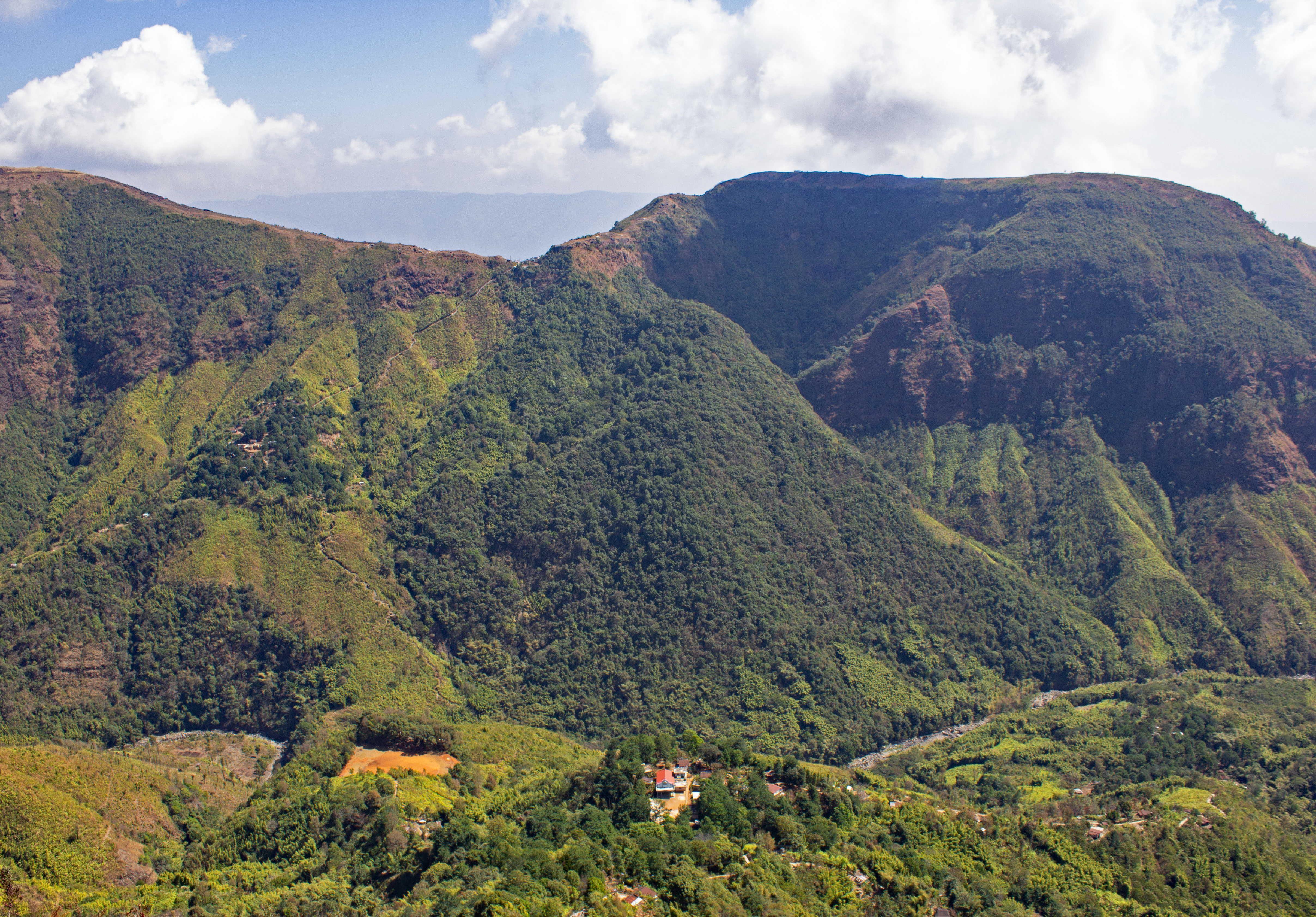
The path to Nongtraw was of the newer cement type, and so was an easy walk. This was a good thing, as I now realized that I still had a great distance to traverse. I could see a small village directly across the valley in a notch atop the opposite ridge, consisting of little more than half a dozen houses. Beyond the notch were the valleys of the deep interior of the Umrew Gorge, and Kshaid, which I still hoped to reach by the end of the day…if I could find it.
The path plunged quickly down to Nongtraw, where I filled my water bottle and made a few inquiries. I wound up talking to two old fellows who were out drying their broom grass crops in the sun, having laid down huge quantities of the plants across a cement porch in front of the village’s catholic church. Regarding the existence of living architecture in the Sohra River Valley, they agreed that maybe there were once root bridges nearby, but that the structures had disappeared long ago.
Then I asked for directions to Kshaid. The two men agreed that to get there I should head for the notch in the ridge opposite Nongtraw. But they weren’t sure if I should turn left or right once I got there.
“Maps, show us maps,” said one of the men. I pulled out my phone and did so, even though I knew that this would not help since Google labels the village in two entirely distinct locations.
“Yes,” said the man, pointing to one of the spots on Google Maps marked ‘Kshaid,’ “Go here.”
The other guy took my phone, and upon studying the map, remarked:
“But it is also here.”
He pointed to the other spot marked ‘Kshaid.’
A lengthy discussion ensued, with much chin rubbing and a long argument as to which spot on the map had a better claim to being Kshaid. The two men never came to an agreement, especially after they noticed that Nongtraw, also, was labelled in completely the wrong place. This occasioned some bitter laughter. The two men seemed to agree that Google Maps was simply ridiculous Phareng tech and next to useless.
“Do not use this. It is all wrong,” said the first man.
“That’s why I’m asking you directions,” I replied.
“Do this,” instructed the second man. He waved towards the settlement in the notch at the top of the opposite ridge. “Go there.”
“And ask,” said the first.
The path slanted away south from Nongtraw through wide expanses of broom grass interspersed with sad, recently burned fields. The Sohra River was only a few meters below, nestled among dense riparian thickets of bamboo and palms.
I soon came to a short bridge of steel wire and bamboo which spanned the thin, clear, cold, stream. Beyond the bridge, the trail led for a short distance gently uphill through a bamboo grove. Then it crossed a rivulet that was barely a succession of puddles, just at the base of a steep, newly made concrete stairway. This led straight up to the small village of Tyniar, a few hundred meters above which was the even smaller village in the notch atop the ridge.
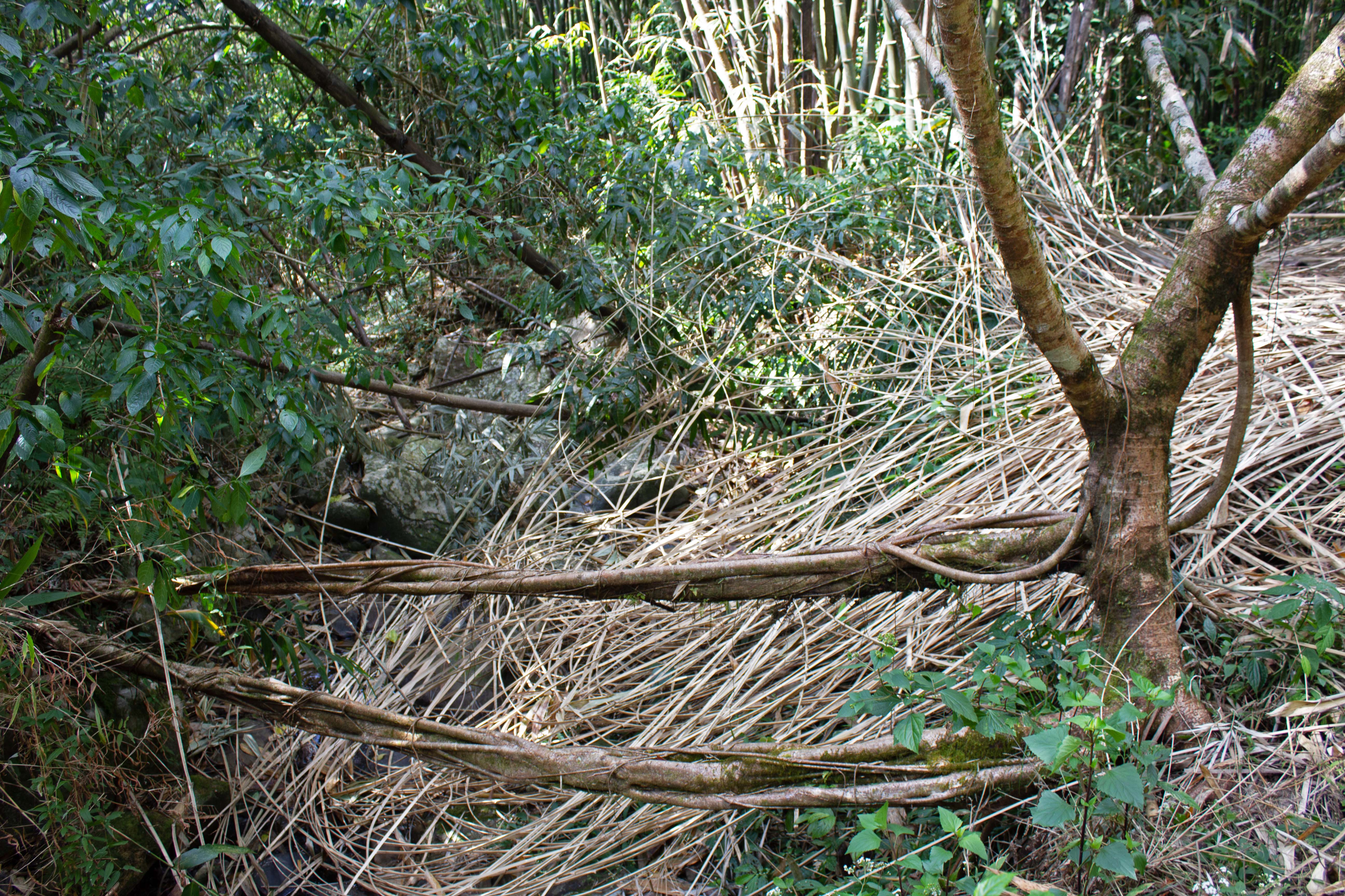
While fording the rivulet, I happened to glance downstream and see exactly what I had been told did not exist in the valley of the Sohra River. There was a living root bridge right next to the trail. But I didn’t blame my sources in Nongtraw for failing to mention it.
Here was the smallest Jingkieng Jri I had ever laid eyes on. It was like a Bonsai version of the famous Double Decker in Nongriat Village. Even the tree it was formed from was tiny. The thickest part of the trunk was only a few inches across, thinner than the narrowest strands of many a well-established root bridge. As for the architectural element of the organism, this consisted of two spans made from several very thin and clearly very young roots wrapped around each other. One span was above and off to the side of the other, as though the lower span was for walking and the upper was for balancing. The bottom of the bridge was held about a meter above the rocks of the stream, while the structure in its entirety was only about four meters long, making it one of the shortest living bridges on record.
The Bonsai Root Bridge is never likely to become a tourist attraction. Even people who live nearby seem to have forgotten that it exists. This is because the amount of thought, time, and effort expended to create the tiny structure was probably quite insubstantial. A single person could have easily planted the ficus elastica next to the stream, twisted together some roots, and occasionally checked on the little structure to make sure it was developing properly. Maybe in the future the bridge will grow to a more impressive extent, but given its current, puny, stature, that time is generations away. In the winter of 2019, it was a small bridge, meant to cross a miniscule stream, which was only used by a handful of people.
In short, it was nothing if not practical.
Tyniar was about 400 meters above the river. Upon reaching the village, I found that it was almost completely empty, with most of the population out working in the surrounding fields. Thus I pressed on without resting to the settlement in the notch above.
As it turned out, the little village in the notch was a kind of road-side colony of Tyniar. It only consisted of, maybe, six or seven small concrete and corrugated metal buildings. To the east, just below the crest of the ridge, was a newly constructed, mostly unpaved, route which led into the heart of the Umrew Gorge. Worryingly, there was nobody around to ask directions from. This left me with two options: I could wait for someone to come by, or I could make a guess as to which way Kshaid might be and keep walking.
I opted for the latter, for the simple reason that the weather had turned rather chilly, and walking would keep me warm. Google Maps had given me two choices as to which direction Kshaid might be: left or right. I chose right, and headed on along the crest of a lonely, windswept ridge.
If you enjoyed this post, please consider supporting me on my Patreon page. There, you can download an extended edition of my book The Green Unknown which includes several chapters available exclusively on Patreon, as well as access a whole slew of other perks.

