The task ahead was to reach the village of Mawphu before sundown. This meant heading north from Nongsteng, at first following a mercifully level path through the warm low-altitude jungle a few hundred meters above the Umiam. After a few comparatively easy kilometers the trail would descend suddenly into the valley of a tributary of the River of Tears known as the Umblai, which flows below a village of the same name.
Like the Rynseit, the Umblai River was once spanned by several living root bridges. Unfortunately, these have all been destroyed, though the sad remains of one can still be seen on the southern bank of the stream. The ficus elastica tree from which the bridge was generated clings stubbornly to life even though the span was knocked out in a landslide sometime in the late 1990s or early 2000s, leaving only the broken off, yet still recognizably architectural, southern anchor of the bridge extending uselessly a few meters out over the river. Rather than using the tree to regenerate the destroyed section of the bridge, a metal and concrete structure was built in its place.
This decision on the part of the people of Umblai village is understandable, if disappointing. At over thirty meters, the root bridge had been an exceptionally long example. Creating a whole new living structure of the same length, and ensuring that it was safe and reliable, would take decades. Add in the fact that the Umblai, like the Rynseit, has reportedly become much more prone to heavy debris-laden floods in recent years, and one can see why a metal and concrete structure was decided upon.
My plan was to cross the replacement bridge and then climb up the opposite slope to Umblai, from where I would ask directions to Mawphu. This would all be rough going, as to get from the bridge to the village one must navigate a spider’s web of constantly branching, intersecting, and fading agriculturalist’s tracks. They’re the sort of trails that only one or two families use regularly. For those families, following the multitude of tracks is perfectly easy since they walk them every day (and have, probably, for generations). But for everyone else, they might as well be trapped in a maze on the side of a hill. I knew that if I simply went up, I’d eventually hit Umblai, given that the village runs for around a kilometer and a half along the crest of a ridge. But my path would almost certainly be winding and inefficient. A great deal of calories would be wasted taking wrong turns and backtracking. I’d come into Umblai from the side, likely popping up unexpectedly in some villager’s back yard.
As I walked in the lonely hot jungle beyond Nongsteng, I could see the distant houses of Umblai high above me, climbing along a ridge ahead. But then, cutting across my trail at a right angle was another path, this one plunging through the forest towards the Umaim.
With enough time in the Khasi Hills, it becomes possible to tell the merely old stone stairways from those that are truly ancient. The path in front of me was one of the later. It was made of sculpted, rectangular, chunks of granite, and shot straight down into the gorge with no attempt made to lessen the severity of its incline. This was a trail made for and by people with ridiculously strong legs. Though I had never taken that trail before, having been in the general area previously I knew that there was only one place that it could lead: Kongkhen, the heart of the Umiam gorge, and the prison of the 16 Villages.
In a confounding bit of geographical nomenclature, the 16 Villages, or Khathynriew Shnong, is only made up of three venerable and closely allied settlements: Thieddieng, Umblai, and Mawphu. However, within each of these are several distinct self-governing localities, or ‘sub-villages,’ which were all established around separate water sources. The word ‘Shnong,’ which is usually translated simply to ‘village’ in English, can also mean one of these ‘sub-villages,’ and thus the term ‘Khathynriew Shnong’ refers not to 16 wholly distinct settlements, but to each of the ‘sub-villages’ that together make up Thieddieng, Umblai, and Mawphu. (And it took me three full visits to the Khathynriew Shnong to piece all of that together.)
While the Sixteen Villages historically submitted to the kings of Sohra, they also had their own self-government, with a combined council led by an official bearing the title of Sirdar. At this council, representatives of all sixteen localities would convene for discussions, votes, and adjudications. The assemblies were held, fittingly, at a point where the trails between the three larger settlements converge at the bottom of the Umiam Valley.
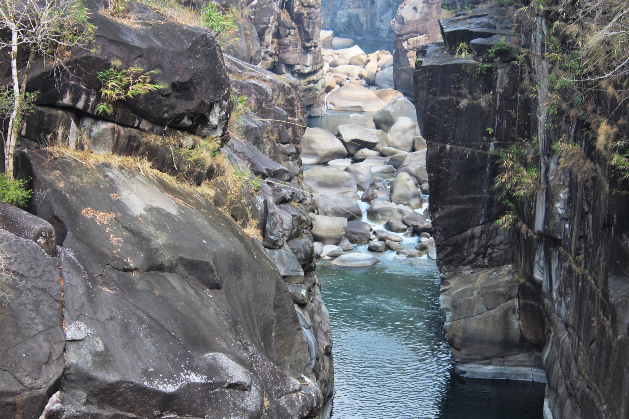
This natural council hall is known locally as Kongkhen, and it is a piece of scenery and geology unique in all the Khasi Hills. Here, the Umiam flows through a straight-walled stone fissure around 60 meters deep. Everywhere else in Southern Meghalaya the land is steep and rocky at the floors of the great gorges, with stony beaches where the sheer jungle slopes slant down to meet the riverbeds. Where there are true rock-walled canyons, the layers of stone tend to be tilted, and the chasms only continue a short distance. But at Kongkhen the bottom of the Umiam gorge is a geologically anomalous narrow, smooth-walled, kilometer long crack in the surface of the world. The walls meet the river at right angles, creating a thin, unknowably deep pool between them into which the whole power of the Umiam is constricted.
Since this natural feature makes up such an important part of the culture of the region, many of the older tracks in the valley lead towards it. For example, Umblai’s primary thoroughfare descends from the bottom of the village and then heads through Areca Palm plantations directly to a steel bridge that spans the Kongkhen canyon. The old stony track I had stumbled upon was likely to lead to roughly the same place.
Now I decided to alter my plans. If I could get to Kongkhen, I could meet up with Umblai’s main trail, and so approach the village from below, rather than via the confusing network of tracks that lead up to Umblai from the side. Also, even though I had many weary miles of jungle to traverse before Mawphu, Kongkhen was more than worth visiting.
And I probably would never get another chance.
The stone steps led down rapidly to the Umblai river, which the path jumped across via a short metal bridge. From there, the trail turned left, leading along a narrow shelf above the stream. I could see another slope, not far ahead on the western side of the Umiam gorge. Kongkhen was close.
Soon the path came to an intersection. To the right another staircase headed straight up, and up, and up. This was the way to Umblai.
But lying face up and motionless on a rock at the bottom of the stairs was an old man. His eyes were closed. He had flies crawling on him. I looked closer to see if I could detect any signs of breathing. I couldn’t. Then I nudged him a little with my foot. No response. Had I found a corpse?
He did have the vinegary smell of village hooch on him. Maybe he was just drunk. His jacket was spread out under him, implying that he probably meant to be laying down where he was. Had he been dead there probably would have been more flies.
All in all, I was pretty sure the man was alive, just blackout drunk. There were of course several rather more forceful ways to check. I could try and find a pulse, though given the kind of shape Khasis tend to be in, this would take a lot of searching. And who could say what a drunk villager would do if he found himself awoken out of a death-like slumber by being felt up by a Phareng?
It wasn’t worth it. Looking at the man again, I saw that he had an old plastic one-liter bottle next to him, of precisely the sort locals tend to carry their hooch in. I was now a good 97% sure the guy was merely wasted.
But that last 3% gnawed at me. Kongkhen was just around the bend. After going there, I’d have to backtrack to the stairs to start up towards Umblai. If the man hadn’t moved by the time I returned, I’d have to go up into Umblai and report that one of their people was dead…or dead drunk. And that’d be weird and unpleasant for everyone involved.
Still, I assured myself that the guy was almost certainly alive…almost…
Now I rounded a bend and came suddenly to the top of a great sheer cliff towering above the blue waters of the Umaim. Through the narrow gorge came a strong, cool, wind borne down by the river from the high country to the north. Reaching across the canyon was a long steel bridge which swayed slightly in the breeze.
The bridge at Kongkhen is composed of rusty old steel cables, along with strips of sheet metal and long Areca Palm trunks that have been laid out on the cables to create a walkway. Though the view of Kongkhen from the bridge is spectacular, the structure itself is rather drab, architecturally speaking.
It wasn’t always thus. I was told by the secretary of Thieddieng village that, while there was never a living bridge at Kongkhen, there was once one that was made entirely from bamboo, which stood where the metal one does now. Given the distance it would have to span, the bamboo bridge must have been one of the most ambitious structures of its sort in the Khasi Hills.
While bamboo is undeniably a durable, versatile, and cheap building material, it tends to rot quickly in the more humid parts of the year in Meghalaya. Architecture made from it is thus cheap, and strong in the short term, but also impermanent and unreliable. If one has a huge supply of bamboo nearby, and so can easily switch out old, weakened poles with fresh ones, this is not a huge issue. But at Kongkhen, the challenge that the shape of the land presented must have made maintaining the bridge a constant struggle. The structure had to extend around 50 meters from cliff to cliff, while hanging a similar distance above the water. Given that the tallest bamboo in the world is only about 35 meters long, building the bridge would not simply be a matter of handing bamboo shoots across the gorge. The structure would likely have been a suspension bridge, using large quantities of bamboo rope to tie a multitude of the tough, flexible, poles together. The builders would have had to make it strong enough to safely carry a constant traffic of villagers, presumably with large loads of produce on their backs, dozens at a time.
Under the conditions that the Khasi Hills subject them to, even modern metal bridges decay at an alarming rate and need regular maintenance. The bamboo bridge at Kongkhen must therefore have been a continual work in progress on the part of the people of the 16 Villages, and a true marvel of vernacular engineering. I’m sorry I missed it.

Stepping out onto the center of the bridge, I looked upstream between the towering cliffs. Vast boulders the size of buildings sat in the Umiam, separated from each other by ribbons of noisy white water. Even now, in the middle of the dry season, the River of Tears possessed an immense, dangerous, power.
In the monsoon, when the volume of the river increases a hundredfold and is constrained more here than anywhere else along its short stampede to the plains of Bengal, Kongkhen becomes a turbid, raging, deathtrap. Short-lived but intense waterfalls pour from the sides of the cliffs into the foaming chute of the canyon, while trees, rocks, all manner of animals, and even the occasional person, are propelled down the River of Tears with such ease that they might as well be made of Styrofoam.
For the people of the 16 Villages, the Umiam was traditionally a source of wonder and terror. Such was the fear of the deeper, colder, more unpredictable parts of the river, that a pool like the one I now stood above was as effective a barrier as any stone wall, a fact the rulers of the Sixteen Villages once used to their advantage.
As the village secretary of Thieddieng had put it two nights before: “When the Sirdar of the Khathynriew Shnong needed to punish a person who has done criminal activities, the council put that criminal in a part of Kongkhen. Between the river and the jungle, there is a cliff. And down from that cliff the river is very deep. No man can swim to the bottom. They won’t even try! But on this cliff, there is one little stone hole. The Sirdar commands that the evil doer be lowered down into that hole, and from there, that evildoer cannot go anywhere! If they jump, they will be drowned by the river. It is a natural jail!”

Looking at the cliffs upstream, I tried to ascertain where the natural jail might once have been. I saw a few likely spots where there were indentations and alcoves in the sides of the chasm, though without a guide, it was hard to be sure which of these was the true prison of the 16 Villages.
Then an unexpected sound came wafting up from the river behind me.
“Jump! Jump! Jump!” called up a multitude of boisterous voices.
Turning around, I scanned the riverbed downstream. There didn’t appear to be anyone there.
“Jump! Jump! Jump!”
I looked some more. No one.
“Jump! Jump! Jump!”
My eyes then caught a bit of movement on one of the vast boulders below. Some young men, perhaps in their teens or early twenties, were on top of the stone, all of them stripped to their underwear and looking expectantly up at me.
“Jump! Jump! Jump!” they called up again, a few of them hopping as if to illustrate what “jump” meant.
These guys weren’t from around there. No local, sensible, 16 Villages person would be in their underwear on a rock in the middle of the River of Tears asking me to commit suicide.
“Jump! Jump! Jump!”
Then I noticed something gleaming in the sun on the riverbank downstream from the loud young idiots: a pile of big beer bottles.
Now it made sense. These were local tourists, probably college kids from Shillong. Their juvenile antics did rather sully the magnificence of the place. For a moment, the image of the beaches below covered in hordes of loud inconsiderate day trippers all talking at the tops of their lungs, getting drunk, and leaving food and litter on the banks of the river, filled my mind. Maybe in a few years the local tourists would be joined by legions of crusty globetrotting Russians and Israelis and Brits and even the occasional moderately adventurous American. Belgians and Bengalis might someday Zipline between the walls of Kongkhen. The horror.
Then I turned around and looked back up the Kongkhen chasm to see the free waters of the River of Tears rushing between the great stone walls.
It was a view very few people will ever see again.
The River of Tears has been selected by the North East Electric Power Company (NEEPCO) for an 85 Mega Watt hydroelectric dam. Building this in the Umiam valley will be a gargantuan engineering endeavor. In addition to the dam itself, all the infrastructure needed to get construction equipment down to the river will have to be made from scratch. Living quarters for an estimated 4000 workers will need to be built. As of the winter of 2019, there were no roads in the valley that reached all the way from the high country down to the river. The dam site was only accessible via ancient jungle footpaths. Therefore, completing what has been officially designated the Mawphu Hydro Electric Project will mean wrenching a place that in many respects still functions as it did 200 years ago into the 21st century practically overnight.
As per the official plans, the river will be impeded about 1.5 km upstream from the Kongkhen chasm. But, unlike most hydroelectric projects where the energy is harnessed directly at the base of the dam itself, here the powerhouse containing the electricity generating turbine is slated to be built a few km south of the planned reservoir, close to 300 meters lower in elevation. A seven-meter-wide tunnel will be excavated deep in the stone of the gorge. This will extend from the dam to the powerhouse, sending much of the water of the Umaim underground before it spins the turbine and generates the hoped for 85 megawatts.
NEEPCO’s environmental assessment claims that the hydroelectric facility will only take five years to build, during which there will be massive increases in the turbidity of the river as tons of muck from the road and dam construction are poured into it. During this period, the population of the area will spike as thousands of temporary workers move into the valley. Given how rarely anyone anywhere ever meets a deadline, it seems safe to assume that, once construction starts, it will be the better part of a decade before the dam is finished and producing electricity.
Upon completion, the water level around Kongkhen is due to be reduced by 80%, with the remaining twenty being released into the riverbed as “Environmental Flows,” so that the river isn’t completely spoiled downstream. Kongkhen’s deep mysterious blue pools will become little more than sad, brown, cold, puddles. Downstream, more tributaries will ultimately feed the river to recover some of its flow, but at Kongkhen the dammed Umiam will only be augmented by a single significant stream: the river that runs through the valley between Umblai and Mawphu.
Of course, all of that is if the project gets built without a hitch. Given the issues that have plagued other engineering endeavors in the Umiam gorge, such as the failed road to Nongsteng, it’s hard to have confidence. Also, the success of the project depends on there not being a catastrophic earthquake in the near future. Given that two world shattering magnitude 8 tremors, along with a host of smaller but still lethal magnitude 6 and 7 quakes, have shaken Northeast India over the past 200 years, expecting one not to occur in the next few decades doesn’t strike me as a safe bet.
The land on which the project is to be situated belonged to the villages of the Umiam Gorge centuries before the creation of the modern Indian state. In order to procure the roughly 110 hectares it needed, NEEPCO invoked the Land Acquisition Act of 2013, which provides for compensation and, if need be, resettlement, of individuals and families affected by large infrastructure projects that are deemed to be in the national interest. This ostensibly makes it incumbent upon the corporation to fairly reimburse all the families in the valley who will have to give up their land, livelihoods, and homes. As you might have suspected, the project has generated plenty of controversy in the valley of the River of Tears.
Two sets of public hearings, the first in May 2017 and the second in November of the same year*, were held by the Meghalaya State Pollution Control Board. In these, members of the villages directly affected by the dam (largely Nongsteng, Thieddieng, Mawphu, and Umblai) were asked to give their views on the project. Detailed summaries of the hearings are easily available online, though they provide a decidedly mixed picture of the views of the people who will have to live for years with a giant construction site in their backyards.
In Mawphu and Nongsteng, most of the respondents seem enthusiastic about the dam, albeit with a variety of minor environmental objections. They also make a few limited demands, such as that the endeavor should be renamed the “Kongkhen Hydro Electric Project” to bring some attention to the cultural importance of the part of the valley that is to be submerged. But as the Chairman of the Mawphu Area Development Committee is recorded as stating in the summary of the May 2017 hearing: “…the project should be implement [sic] by NEEPCO since it will generate employment and uplift the people of the affected area.” That sentiment seems to be the main takeaway from Mawphu, and the primary reason why a majority of the people living in the Umiam Gorge, as far as I can tell, support the project.
According to the Environmental Impact Study, over 40% of the population of the area is officially considered unemployed, though what exactly this classification means in the context of the Khasi Hills is not clear. It’s a rare Khasi who is able bodied and not involved in agriculture in some way. Still, the project promises a quota of jobs for the villagers directly adjacent to the dam building which will likely pull in more cash than agricultural work in the short term. Beyond that enticing prospect, the project also means permanent roads, a commitment to provide the region with schools and health care centers, along with a chance for the locals to set up businesses such as shops and tea stalls to cater to the temporary population of workers that will be descending on the valley. Those arguments seem to have largely won over the people in Mawphu. And, certainly, when I arrived in Mawphu the next day, everyone I talked to appeared hopeful that the project would lead to a higher quality of life. It’s hard to hold that against them.
However, the village the project will affect most is Thieddieng. The lion’s share of the dam infrastructure is due to be built on the western side of the river, meaning that a large part of Thieddieng’s agricultural land will be seized. In the May 2017 hearings, though the acting headman of the village is recorded as supporting the project, (just so long as it is renamed the “Thieddieng Hydro Electric Project”) out of 29 speakers, 16 oppose the dam, all of them quite vociferously, while only 11 support it, and 2 don’t really express an opinion.
The main reason for the opposition is easy to understand: NEEPCO is going to grab a huge swath of land on which the villagers of Thieddieng depend. In a tricky bit of surveying, much of the territory that the company is seizing has been classified as presumably unproductive “Forest Land,” rather than “Agricultural Land.” This simply ignores the traditional mixed pattern of agriculture practiced in the region, whereby crops are interspersed with wild growing flora over a wide area, and the dividing line between land that is being used for agriculture and land that is being left wild is not clear cut. For example, a Jackfruit tree may be growing by itself in a patch of uncultivated jungle, but a family might still own the tree, eat the fruit, and later sell the highly valuable wood. Something similar can be said of the ficus elastica trees found in the Khasi Hills: these are unsuited to growth in a plantation, and so are often found far out in the middle of essentially wild areas, but they are nonetheless owned, tended, and used both for their architectural properties and for their latex.
As one man from Thieddieng opines in the record of the May 2017 hearings: “there is no forest land in the village as the land is filled with fruits, betel nuts, betel leaf and other cash crops all the way from the proposed dam up to the proposed power house area. He pointed out that for a farmer like him he wishes to preserve the agricultural land for the betterment of the present & the future generation. He further, stressed that he does not want to part with his land for the proposed project & as such he strongly opposed the project [sic].” The representative from NEEPCO blandly responds to this by asserting that the company’s assessment of the land is more accurate than that of the people who live on it, and that it’s unpatriotic to be so disgruntled: “Forest land of 22 ha is as per assessment of State Forest Department…Generation of clean and green power is also a need of the nation for its development and for future generations.”
In accordance with the Land Acquisition Act of 2013, NEEPCO will have to compensate the villagers that are to be dislocated. Every household that will be moved is due to receive a lump sum of Rs. 25,000 (roughly 350 U.S. dollars), plus Rs. 2000 (about 30 dollars) every month for twenty years. To someone from the U.S., Europe, or middle-class parts of India, this looks almost like a cruel joke. Of course, Rs. 2000 goes much further in rural Meghalaya than it does in other parts of the country, but even to the people of Thieddieng the compensation is a meager price for land that has been in their families since before the advent of the written word in the Khasi Hills. As one man is recorded expressing in the May 2017 hearings: “He informed that what he is today is because of this land and that not one inch of their land will be allowed to be taken for the hydel project. The compensation money as presented is not enough [sic].”
The negative reaction from Thieddieng was so strong that after a flurry of protests and news articles another hearing was held later in 2017. But by the time that one happened, the opposition to the project in Thieddieng had diminished. Of 24 speakers, only 11 were now against the project, while 14 were for it. And in the end, the controversy seems to have subsided. After all, Thieddieng is finally getting its road to connect it to Mawsynram after a cool 40 years, a result of the infrastructure investment that the dam will bring to the area.
Now a majority of the region supports the project. The people of the Umiam gorge seem mostly to desire economic security, reliable infrastructure, and a constant supply of electricity. And really, who doesn’t? Some like to romanticize living off the grid, but that’s only until they have to go to a hospital.
But, you might ask, does Meghalaya really need the extra energy?
The answer is a resounding yes, as the state’s needs badly exceed its supply. For up to six months of the year Meghalaya is subject to daily rolling blackouts where certain locations are made to go without electricity for up to three hours at a time. These occur during the drier months of the year, when completed hydroelectric facilities elsewhere in Meghalaya and in other parts of India are generating less than their full potential. But in the wet season, when the turbines are always spinning fast, different vulnerabilities in the region’s electrical infrastructure lead to the power being cut for various reasons (lightning strikes, landslides, flooding, etc.), often for days or weeks at a time. In short, one can never count on the lights coming on.
The need for energy in Meghalaya is very real. Whether or not a dam such as that proposed in the Umaim Valley is the best solution to meet this need is an exceedingly difficult question. Personally, I’ve never been a great fan of hydroelectric power. It’s always seemed like the most environmentally detrimental source of ‘green’ energy out there. Maybe in choosing hydroelectric over coal you avoid pumping more CO2 into the atmosphere, but instead you ruin a river, and a valley, and in this case displace thousands of people and permanently erase a virtually unknown and unstudied cultural history. And if a giant earthquake strikes the Umaim valley, the dam and its construction may lead to both catastrophic landslides and a giant flood. The loss of life under those circumstances could be huge. The cons are very strong here.
The region is, it should be noted, blessed with vast and easily accessible coal deposits, but strict environmental regulations make relying solely on coal plants a moot point. Nuclear energy is similarly unfeasible. Solar power in the ‘Abode of the Clouds’ is an oxymoron. Like it or loathe it, at present the most obvious source of energy for the state are the powerful streams that pour over its steep terrain. But if this energy is harnessed to its fullest potential, damming all the great canyon-cutting rivers from the Kynshi to the Umngot, the loss to Meghalaya’s natural and cultural heritage will be incalculable.
I’m not sure what the solution to this problem is.
“Jump! Jump! Jump!”
The obnoxious hopping tourists down below really wanted me to leap off the side of the bridge. There was a pool directly below, one deep enough that if I did jump, I’d probably survive. Thinking on it, this would likely be my last chance to plunge into the Umiam at Kongkhen.
“Jump! Jump! Jump!”
Then again, it was a 50-meter drop, and I’ve never much enjoyed the sensation of hitting water.
I put my hand to my mouth.
“No!” I called out.
The day trippers looked disappointed. Their hopping ceased. But it was just as well that I didn’t humor them. They needed to get back to enjoying Kongkhen.
Somebody ought to before it’s transformed.
Turning around, I started back towards the trail to Umblai. Reaching the intersection, my heart sank a bit when I saw that the old man on the ground had not moved. His pose was exactly the same. Just as many flies were crawling on him.
Now I went and stood over him. There was still no sign of respiration. I started to plan ahead, wondering how hard it would be to explain that there was a dead guy near Kongkhen to a random villager in Umblai who didn’t speak much English.
Then the guy opened his eyes.
“Ahhh!” he grunted, nowhere near as surprised to see me as I thought he would be. His breath was so heavy with local hooch that I was afraid I might get buzzed just by inhaling in his vicinity.
He stumbled to his feet, then pointed shakily in the direction of the metal bridge.
“Ahh…Kongkhen?!” he blurted out.
“Yes, it is,” said I, relieved that the guy was still alive, but wondering what he was going to do next.
The man stood, blankly, for a moment or two, tipsily swaying, his eyes only half open. Then he laid down and went back to sleep.
I bet he doesn’t remember me.
* A pdf of the November hearings was available online as of 2021, but seems, as of November 2023, to have been removed.
If you enjoyed this post, please consider supporting me on my Patreon page. There, you can download an extended edition of my book The Green Unknown which includes several chapters available exclusively on Patreon, as well as access a whole slew of other perks.