Long ago, the two daughters of the God of Shillong Peak, Ka Ngot and Ka Iam, decided to have a contest. They would both transform themselves into rivers and forge separate paths down through the hills, all the way to the plains of Bengal, and whichever reached the city of Sylhet first would be the winner. Ka Iam, the prouder and more forceful of the two, chose to cut her way to the plains via the straightest, though also rockiest, path. Ka Ngot, being less sure of herself, opted to follow a longer, more meandering route, across easier ground.
When the day of the contest came, Ka Ngot set out at a deliberate pace. Finally, after many twists and turns, she emerged from the base of the hills and onto the plains of Bengal, whereupon she proceeded all the way to Sylhet, fully expecting her sister to be there when she arrived. But much to her surprise, Ka Iam was nowhere to be seen, so Ka Ngot wandered about the base of the hills, cutting many a curving, shimmering, channel through the flatlands as she searched for her sister.
Meanwhile Ka Iam was excavating her own valley through the hills, but the way was hard and steep. Thinking that there was no chance that her far less powerful sister would make it to Sylhet first, Ka Iam took her time, expending great effort and energy wearing down the hard bedrock. But much was her surprise and embarrassment when she finally burst out of the hills in the vicinity of the village of Shella and saw before her the plains sparkling with the lazy streams her sister had created, having long since won the race.
And so, Ka Iam wept. From that day onwards the winding Umngot River, which bears Ka Ngot’s name, was considered greater, and more worthy of veneration, than Ka Iam’s river, the Umiam, the ‘River of Tears.’
The river I now had to cross.
There is no valley deeper, darker, and more redolent of the Khasi Hills of old than that which separates the great peninsulas of limestone tableland that are crowned with Mawsynram, to the west, and Sohra, to the east. Here the Umiam does indeed, much as the myth of its origin suggests, slice straight through the hills almost as though a giant knife had been dragged through them. The deepest part of the valley is not wide: a mere eight kilometers separate the bare black limestone cliffs on the eastern and western rims of the gorge. But there’s a 1200-meter drop between them. Ancient stone trails plummet from the cool misty heights of the tableland all the way to the steaming hot jungle next to the riverbed in a straight-line distance of less than three kilometers.
Broom grass cultivation is not well along here; the area is simply too steep. Many of the jungles of the gorge are still wild, though a significant portion of the lower land has been turned into Areca Palm plantations, the economically vital trees being well suited to growing on near-vertical hillsides. But what really sets the area apart, agriculturally speaking, are its oranges. These are renown throughout Meghalaya and were once traded far and wide, reaching markets deep into Bengal. Even today, if you see orange sellers in Sohra, they’re likely from one of the villages deep within the Umiam gorge. And if you happen to be lucky enough to be walking through the canyon when oranges are in season, the locals will likely gift you so many of the delicious fruits that you’ll quickly run out of places to put them. Orange trees line the paths in the villages, and for the few weeks when the lovely citrus fruit is ripe, it becomes just as much a part of daily life in the gorge as kwai and tea.

After an easy walk along the road through the misty tableland east of Phlangwanbroi, I came to the outskirts of the mid-sized town of Mawsynram. Large buildings loomed up ahead. Hotels appeared on either side of the road. The ease of a break from trekking in a reasonably cosmopolitan place with clean sheets, hot water, and restaurants, was within my grasp. But this wasn’t a day for rest.
Jutting off to the right of the highway, skirting the environs of Mawsynram, was a rough four-wheel drive track. It led to Thieddieng, a village deep in the jungle of the Umiam canyon. This was my path.
I had been to Thieddieng once before, back in 2013, though at the time I came there on accident, having gotten terribly lost trying to reach the settlement of Mawphu. My recollections were hazy. In 2013 I had reached the village at dusk, disoriented and exhausted, and had left early the next morning. My home that night had been a very poor man’s hut at the bottom of the settlement. What memories I had of Thieddieng mostly took place inside that hut and consisted of being offered vinegary illegal rice wine in tiny ceramic teacups. The experience had its lessons, though I left knowing little enough about the village.
Now the plan was to try and learn a thing or two about the place.
But first I had to get there.
The “road” between Mawsynram and Thieddieng is a rock-strewn scrape in the side of the upper Umiam gorge which, judging by the sheer depths of its ruts, is best attempted by vehicles with caterpillar tracks. It was first excavated back in the 1970s, when it was planned to connect the village with the town. But then the funding ran out, leaving Thieddieng with an unfinished and poorly maintained road that only extended three quarters of the way to the settlement. For decade after decade, the people of the village petitioned the government to finish the project, and for decade after decade Thieddieng remained lost in the jungle.
After briefly heading east upon leaving the highway, the road turned north and descended gradually across rocky plunging slopes covered in thin grass. Scrappy groves of tough green fan palms with sharp fronds crowded around the rills and little canyons that tumbled to the River of Tears. Somewhere on the gray slopes above was Mawsynram, but as I followed the road further down into the gorge, the town, with its hotels and restaurants, felt worlds away.

The road descended further, and the land became more verdant, the palms now covering much of the slopes directly below. The air was already noticeably warmer, though it was also thick and misty. The views to the east, over the Umiam canyon and to the highlands on the other side, were not nearly as spectacular as I knew they could be. In the opaque atmosphere, the opposite slope of the gorge was only discernible as a faint grey blur in the distant murk.
Ahead I saw four steel cables slanting far down into the misty gorge, from which hung a small, heavily rusted metal basket. The cables descended from a rundown concrete building on the left side of the road about fifty meters uphill.
This was one of Meghalaya’s ubiquitous mechanical ropeways. The idea behind these, which seems perfectly workable at first glance, is that the machines can be used by settlements in rugged, remote, areas to help get produce to market. Rather than employing porters or hauling up the produce on their backs, villagers at the bottoms of Meghalaya’s many valleys can, theoretically, pay a small fee to use a ropeway to get their kilos upon kilos of broom-grass, bay leaves, betel nut, etc., up the brutally steep slopes. The problem is that the ropeways require both training and maintenance. These tend to be lacking.
Despite having come across numerous ropeways over the years, I’ve only seen a single example in action. Mostly, the work they perform is to provide villagers with an anti-government conversation piece. The way it’s usually portrayed to me by locals (and so should probably be taken with a grain of salt) is that the state government comes in and builds the ropeways with much fanfare, but then does little or nothing to keep them operating. The villagers are, ostensibly, to be trained in maintaining the machines. However, keeping a ropeway functioning is no simple task, and once a major element of the machinery fails it can take months or even years for the government to supply a replacement part. While ropeways make the villagers lives easier in those rare periods when they do work, they’ve never really supplanted the more common, labor-intensive, means of transporting crops, namely, human muscles.
To give an example, in the village of Nongkwai a ropeway was built in 1997. The village needs it, as it is a steep, sun-exposed climb up from Nongkwai to the nearest market in the town of Pynursla. But the ropeway failed after two years and was only replaced nearly a decade and a half later, in 2013. Walking to Nongkwai later in my trek, I saw the new ropeway, though nobody seemed to be manning it, and a steady stream of people were still climbing hundreds of meters up from the village with unconceivably huge bundles of produce on their backs.
It’s true that ropeways dot the Khasi Hills, but very few of them are operational. In a brief article in the Meghalaya Times from 2013, the claim is made that there were 106 ropeways in the state at the time of writing, but that only 45 were operational. Frankly, I was surprised that the number was even that high.

Beyond the ropeway, the “road” became a kind of shelf clinging to the side of a green slope covered in low underbrush, short thin bamboo, and scraggly trees. The real jungle was getting closer, though the land around me was still too steep to support anything taller than a few meters. Now that I had come a long way down, I began to make out clusters of corrugated metal roofs scattered in the forest far below: Thieddieng.
If you’ve ever been to famous Nongriat, you might very well have heard that name. The clans of Nongriat and those of Thieddieng were once neighbors, but then the two villages went to war, probably sometime in the early 19th century. Evidently there wasn’t enough room in the area for both. One of the villages began to encroach on the land of the other. A battle erupted, one in which the village secretary of Thieddieng assured me “many people’s heads fell down.” Nongriat eventually lost and fled to its present location a few kilometers east. But the fight was not a walkover. While Thieddieng was a much larger settlement than Nongriat, its people still found that they needed to call in help from an allied village: Mawphu. It was only after Thieddieng was reinforced that they were able to subdue Nongriat.
As for who started the whole thing, I still haven’t gotten a straight answer.
Interestingly, the name “Thieddieng” simply means “Tree Root,” and this has led some of the folks in Nongriat to speculate that they might have gotten the idea of making architecture from ficus elastica roots from their erstwhile neighbors. This theory has further morphed into the notion that the people of Thieddieng might be the true inventers of living architecture, and that the practice spread out from their village over the centuries. Unfortunately, I don’t think there’s any solid evidence for this, though the speculation that the people of Nongriat got the idea from the people of Thieddieng seems possible, if not provable.
But roots did nonetheless play a major part in the history of Thieddieng. It’s said that when the founders of the original settlement were first migrating into the area, they were faced with an obstacle: they could see that there was a ridge above them that would make a good village site, but to get there they somehow needed to traverse a great cliff that was in their way, which was impossible to scale, except, as was found after much searching, by a single root that led down the escarpment. The pioneers climbed this one by one to reach the land that their descendants would occupy for centuries to come. Then they named the village they had founded after the fortuitous root.
That story comes from the prehistory of the Khasi Hills, when Thieddieng was impossibly remote. Yet, even with the coming of the British and the later incorporation of Thieddieng into the Indian Nation, the village remained largely cut off from the rest of the world well into the 21st century. Perhaps this would not have been the case if the road from Mawsynram had been completed in the 70s, but as it stood, the incredible ruggedness of the Umiam Gorge meant that in many respects life in Thieddieng in the winter of 2019 resembled what it had been like in centuries past.
But it won’t for long.
The afternoon had given way to evening, and it was getting darker with each passing minute. If I was going to reach Thieddieng before nightfall, I needed to get there soon.
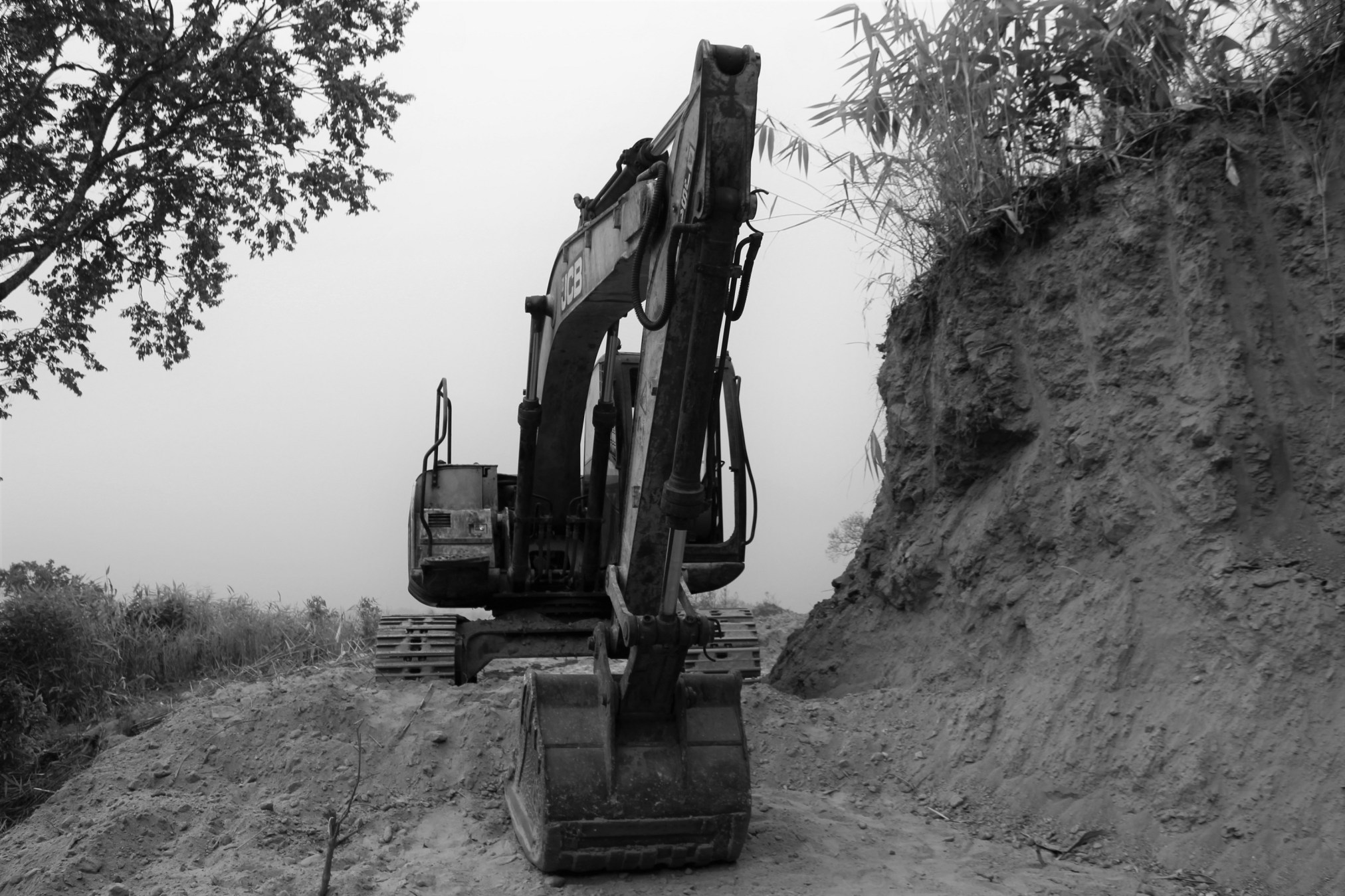
As I descended further and further into the Umiam gorge, the slopes above and below became covered in thick green growth. And then the unfinished road came abruptly to an end at a little labor camp consisting of several impermanent looking huts made from bamboo and blue plastic tarps. Above the camp, leading up the slope towards Mawsynram, was a traditional stone pathway that the people of Thieddieng have used for centuries. Below it was something very different: a brand-new road winding down into the jungle that was so freshly torn from the side of the gorge that Google Maps showed no sign of it. This new track was much wider than the road I had followed for most of the day. Its surface was powdery and red, while slopes of loose orange dirt and gravel poured down from it into the forest below.
My intention was to try and locate what remained of the ancient stone stairway and follow that to the village, assuming the traditional trail would provide the fastest route. But this proved impossible. A large section of the venerable stairway had simply been buried.
There was nothing for it now but to follow the new road downhill. Soon I was covered in red dust. The track must have been under active construction only a few days or even hours before. Thieddieng had never before, in its entire history, been accessible by motor vehicles. I had shown up almost exactly when the cars arrived.
But the condition of the new road did not inspire confidence. Whenever I stepped near the outer edge of it, little cascades of loose dirt and gravel tumbled off the side of the track down into the dust-caked jungle.
It was getting dark. But Thieddieng was close. I could hear children playing in the village. Looking forward to finding a place to rest for the night, I rounded a bend, but was then presented with an annoyingly perfect visual metaphor for Thieddieng’s place in the world.
Without the slightest warning, the new road came to an end in the jungle. A great big yellow backhoe was parked right where the dirt stopped and the trees began. Beyond this, close enough that I could see people in the windows of its houses, was Thieddieng. Very recently, perhaps even while I was walking down from Mawsynram, the backhoe had been digging its way towards the village, bringing the unstable dirt track a few meters closer. But it wasn’t quite there yet. A tiny sliver of unconquered jungle intervened between the road that led all the way to Mawsynram, to Shillong, to Delhi, and the old Khasi village in the valley of the River of Tears.
There was no trail from the end of the road down to the village, and night was closing in. I was now in the ridiculous position of being within earshot of Thieddieng and yet having to camp in the jungle.
My only option was to turn around and push back up the dusty track. The plan was to reach a spring I had spotted uphill, fill my bottles, and then locate a spot in the jungle to sleep. The next day I’d have to find someone who could give me directions to the village which was so infuriatingly close.
I walked silently back uphill through the ever-dimming evening, feeling more and more frustrated as the sounds of the village grew louder, the families in the houses below gathering and talking as people came in from the fields for the night. Then I saw a dim figure in the twilight ahead, coming down the road. I asked him how to get to Thieddieng, whereupon he showed me a miniscule track sloping down through the loose dirt to the side of the road; a path so faint and unstable it never would have occurred to me to take it.
I made it to Thieddieng only to find that I still had a great deal of hiking ahead of me. The village is situated along the spine of a long verdure covered ridge and consists of a succession of widely spaced clusters of houses, the highest of which is nearly 300 meters above the lowest. Connecting all of these is a long, steep, staircase, following the course of an ancient trail which has existed since the village’s founding.
I spent a long exhausting time in the evening’s last twilight climbing the old stairs looking for a place to sleep, a source of information, and a representative of the local government. I had managed to descend several hundred meters along Thieddieng’s spine when I was finally directed by a middle-aged lady, the village secretary’s wife, to turn right around and follow her back up the same few hundred meters to her house near the top of the settlement.
There, I was instructed to wait in her small but cozy wooden abode for her husband, who had been away for the day running an errand in Mawsynram.
It was a long wait. I nodded off a few times, despite having been served around half a dozen cups of tea. When the village secretary, a wiry, distinguished-looking fellow, walked in at around 8pm, he appeared thoroughly exhausted as well, and didn’t seem to be especially enthusiastic about talking to me. For a while he gave back laconic non-answers to my questions about the history of the village, claiming that he didn’t know much of anything, and that I should find someone else to talk to. But when I mentioned that I had been to Thieddieng back in 2013, he seemed to warm up to me a bit. The village secretary had heard about me that night more than half a decade before.
This, supplemented by several additional cups of tea and doses of kwai, gave me the confidence to press him on my main question.
“I’ve heard that there is a living root bridge in Thieddieng? Do you know if this is true?”
The answer, finally, was affirmative. And there was not only one. There were three. After so many days of trekking, exhaustion, confusion, sickness, etc., it was reinvigorating to finally come to the things I had walked so far to learn about. The info-scraps that had led me to suspect that there might be living architecture in Thieddieng had indicated that there would only be a single, small, example on the village’s land. To learn that there was such a significant concentration in the area was a major discovery.
From what I’ve seen over the years, it seems that living architecture in Meghalaya is mostly found to the east of Mawsynram. In the Umiam basin, which includes both Thieddieng and far more famous Nongriat, living architecture is a significant part of the local culture. But in the next few valleys to the west, those of the Umngi and the Kynshi, the practice doesn’t appear to have ever been particularly widespread. Why it should stop at Mawsynram, or why there should be one isolated major example of living architecture so far to the west in Nongnah, are mysteries for a trained anthropologist. However, it can be definitively said that it is at the village of Thieddieng that the land of living root bridges truly begins.
According to the village secretary, all three bridges were close by, and could be reached within a few hours. He then set me up with a guide, his nephew by the surprising name of Chesterfield, who would lead me out to the bridges the following morning. Chesterfield was about 18 and spoke significantly more Hindi than he did English. He was also a devote Catholic and made sure everybody knew it by always wearing a large plastic crucifix around his neck.
The next morning, before breakfast and with nothing in me but a cup of black tea, Chesterfield and I plunged into the jungle to the west of Thieddieng, climbing down slopes covered in Areca Palms, Jackfruit and Bay leaf trees, and then uncultivated thickets of deep brush, to the bed of a small but vigorous rivulet. Our goal was to reach the root bridge that was furthest from the center of the village. Its name was Jingkieng Kyn Soh Sait, which has something to do with swollen fruit.
This was not a root bridge that serviced a major trail. The confounding network of treacherous, intersecting, steeply inclined paths that we walked down had the look of minor tracks known only to a few families. I would have been completely lost here without a guide.
Yet Chesterfield was getting further and further ahead as we descended, his bright red shirt only occasionally visible as it flitted amongst the greenery below and ahead. Then, as I pushed my way through the thick undergrowth, Chesterfield unexpectedly emitted a piercing “AWW!!” sound, like a loudly yipping dog. He did this once every minute or so, which was fortunate since when I couldn’t see his shirt the sound was the only way for me to determine, approximately, where he was. Each time he called out, two answering yips, one seemingly in the same valley, and one much further away in the ridges above, would follow.
This was a kind of Khasi echolocation. A proper loud yip is a way of announcing your presence, ascertaining if there is anyone else out there in the jungle with you, and getting some idea of where they are. Plus, it serves to combat the boredom and loneliness that comes with long hours of often solitary jungle-work. Judging by the sharp tenor of Chesterfield’s yips, he had spent much of his life training his voice to carry as far as it possibly could over the ridges and valleys of the Umiam Gorge.
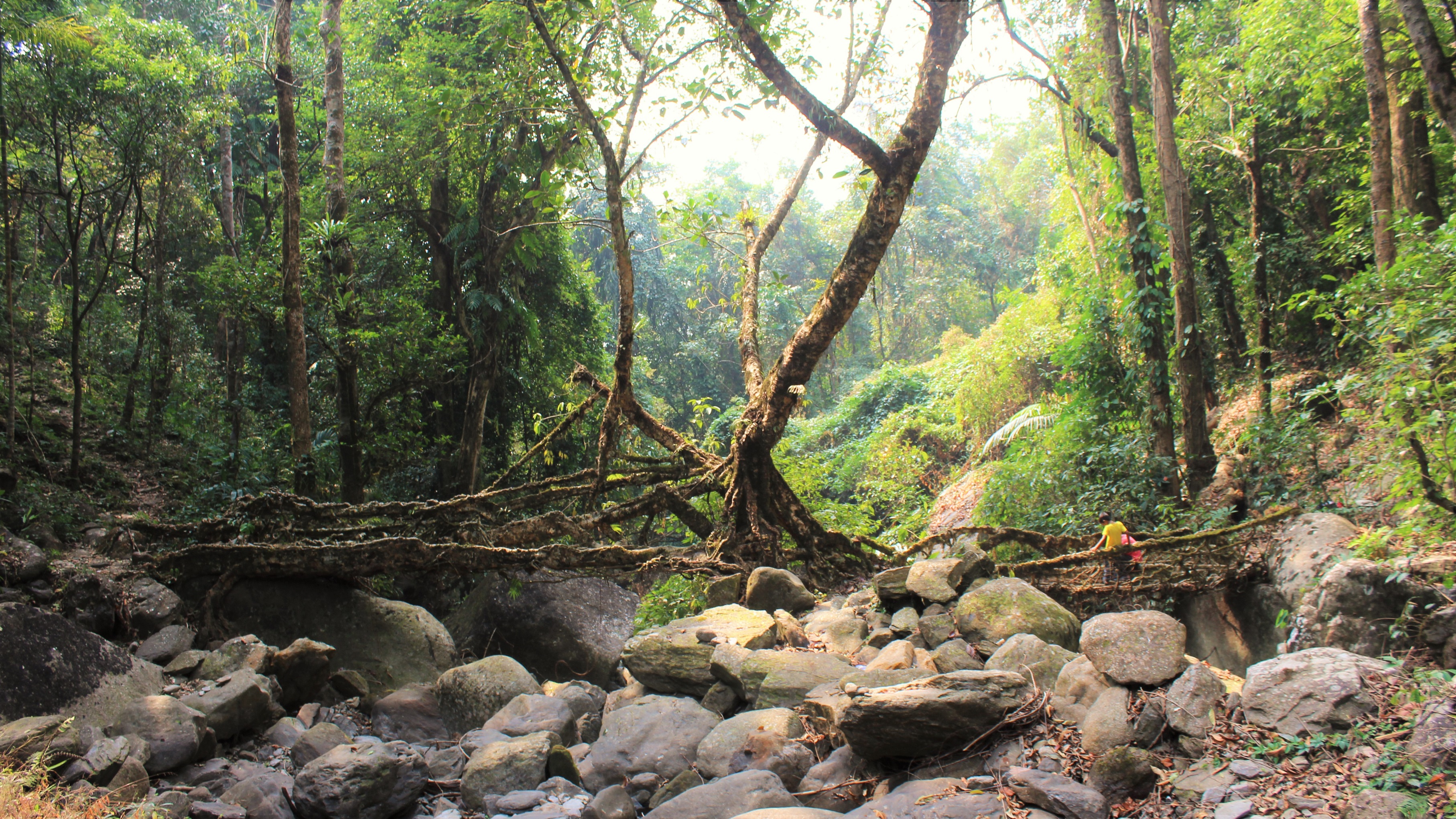
I began to hear a small river trickling softly somewhere below. Then I rounded a bend and was finally able to see down to the rocky stream at the bottom of the little valley. Crossing this was an old beat-up root bridge on which Chesterfield and another fellow, presumably one of the distant yippers, were sitting, sharing a wooden tobacco pipe and having a chat. The bridge consisted of two living spans which reached out to the opposite banks of the river from a large rock in the center of the stream. It was atop this boulder that the hoary ficus elastica tree from which the whole bridge was generated had first been planted, generations ago.
It was not a lofty root bridge, being only two or three meters above the riverbed. Because of this, it was often covered in turbulent water and scoured by debris coming down the stream during the monsoon season. Yet, despite this rough treatment, the structure had stood the test of time. It had been around long enough that nobody remembered who first planted it. As for how old it was, the best answer I could get from the village secretary was that it had been in existence for “more than a hundred years.” While it was not, as living root bridges go, an especially long example, its roots were thick, scarred, and knotty. It had seen many passing seasons. This, combined with the age of Thieddieng itself, makes “more than a hundred years” a perfectly plausible figure. But having been planted well before either living memory or written records, the true age of the living structure must, in the absence of a scientific study, remain a mystery for the foreseeable future.
From Jingkieng Kyn Soh Sait, we turned around and headed back up out of the little valley. I followed Chesterfield slowly, step by step, up the side of the hill, until the houses of Thieddieng came back into view through the jungle above. Now both hungry and dehydrated, I felt something which would be a feature of the trek from that point forward: every few days I’d be struck with deep fatigue and a feeling that my body was struggling to find the calories to get me up and down the hills. When I started my trek, I was, by the standards of southern Meghalaya, a great big fatty. But the last time someone called me fat was before Mawpdai. The Khasi Hills were knocking the pounds right off me.
The next root bridge would prove to be one of the oddest I’ve ever seen. It was only about four meters long, spanning a small nearly dry stream which flowed down into the village from a spring a few hundred meters uphill. As old as Jingkieng Kyn Soh Sait manifestly was, this smaller living structure was even older. So old, in fact, that it had long-since ceased to be used. A concrete bridge across the riverbed had been constructed downstream decades ago, rendering the living structure redundant.
But though the bridge was abandoned, the ficus elastica plant that had been grown to cross the river was still very much alive. In years past, the roots of the tree must have provided an easily useable path across the river, but since then the ficus elastica had grown out of control. The roots that made up the span had multiplied, widened, and then combined with one another to form a great round trunk leading from one side of the stream to the other.
As I went and found out for myself, the shape of the trunk was such that crossing the bridge, while possible, was extremely awkward. Doing so carrying a large load would have been a struggle, I suspect, even for a nimble and well-exercised Khasi. The people of Thieddieng therefore opted to abandon the root bridge for a more conventional concrete structure, in the process illustrating one of the less commonly emphasized disadvantages of living architecture: if the development of the structure is not carefully controlled, a root bridge can grow itself into functional uselessness.
It was, again, impossible to say how long ago this bridge was first brought into being. Chesterfield and the village secretary could only say that it had probably been there since the very earliest days of Thieddieng. Given that we can’t say how long ago those were without an archeological study, inexactitude reigns.

Now we headed off to the third living bridge. This was located on the eastern slope of the ridge Thieddieng occupied, at a narrow canyon called Ur Ka Jynro. An agricultural trail, heading mostly through pineapple and broom grass plantations, crossed this stony gorge via a root bridge which, in stark contrast to Thieddieng’s other examples, had been created within living memory. According to the village secretary the person who first planted the living bridge is no longer alive, but his son, now an old man, is still around. This means that the structure was probably first created sometime in the second half of the twentieth century.
The name U Ka Jynro translates, roughly, to “Ka Jynro’s Fall.” It’s said that a little way downstream from where the bridge crosses the canyon, a woman named Jynro killed herself by jumping off the side of a stony precipice, adding her name to a collection of notable cliffs and waterfalls in southern Meghalaya associated with suicide. Apparently, if you want to off yourself in the Khasi Hills, the region’s precipitous terrain helps to narrow down one’s choice of methods.
Aesthetically, the living bridge at Ur Ka Jynro is the most pleasing in Thieddieng, and perhaps all of the Umiam gorge outside of the tourist area of Nongriat. At about ten meters long, the bridge is made up of a great number of moderately thin ficus elastica roots that still wobble slightly when you walk across them. The treewas planted somewhat off to the side of the span, affixed to the wall of the canyon, with the rubber roots being first pulled laterally along the lip of the gorge before making a ninety degree turn as they leaped across the gulf. From what I could see, the bridge was in good health. The roots were undamaged by human hands and appeared high enough up off the stream bed that they were unlikely to be scarred by material washed down in monsoonal floods.
As if to demonstrate that the village council was doing a good job maintaining the root bridge which bore Ka Jynro’s name, Chesterfield started twisting, tying, and guiding roots on the span to encourage them to combine and reinforce the structure. This often happens when I’m led to living root bridges, and it’s hard to shake the suspicion that it is only done to make a show for the visiting Phareng. Thieddieng, just like most villages in the valleys of southern Meghalaya, has only been made aware of the uniqueness of its living architecture in the past decade and a half. This means that their conservation efforts are still at an early stage. It was only in the past few years that the village council instituted harsh punishments for anyone who damaged a root bridge. So, if my showing up provided an additional impetus for Thieddieng to maintain its living architecture, then that’s all for the best.
Of Thieddieng’s root bridges, one, that at Ur Ka Jynro, is likely to survive far into the future. It might even become Thieddieng’s postcard shot, after the fashion of the world-famous Double Decker root bridge of Nongriat. But the other two bridges, which are not as picturesque and so are far less likely to be sought out by tourists, still provide valuable information regarding the history of living architecture in the area, and so merit preservation.
Hopefully, Chesterfield will actively maintain all three.

After visiting Ka Jynro’s Fall and retrieving what information I could on the root bridge, I returned to the village secretary’s house and had a meal consisting almost entirely of white rice. Then it was time to depart. As with all the villages I walked through during my long trek, my few hours in Thieddieng were at most a brief reconnaissance. That afternoon was just one more occasion when I deeply wished I had more time.
Bidding farewell to my kind host family of less than a day, I started the long descent over ancient jungle paths to the River of Tears, down, and down, and down.
If you enjoyed this post, please consider supporting me on my Patreon page. There, you can download an extended edition of my book The Green Unknown which includes several chapters available exclusively on Patreon, as well as access a whole slew of other perks.