It was among the hardest walks I’ve ever taken, and among the most beautiful. Morningglory, his dad, the ever-boisterous John Cena, and I, set out from the village of Mynrieng, our objective being to cross the river Umrew and then enter the heart of a region I had looked out upon for years and yet had never entered: Katarshnong. The name means ‘Twelve Villages’ though the area it is applied to confusingly holds somewhere between twenty-five and fifty settlements, the original twelve having divided and multiplied over the years.
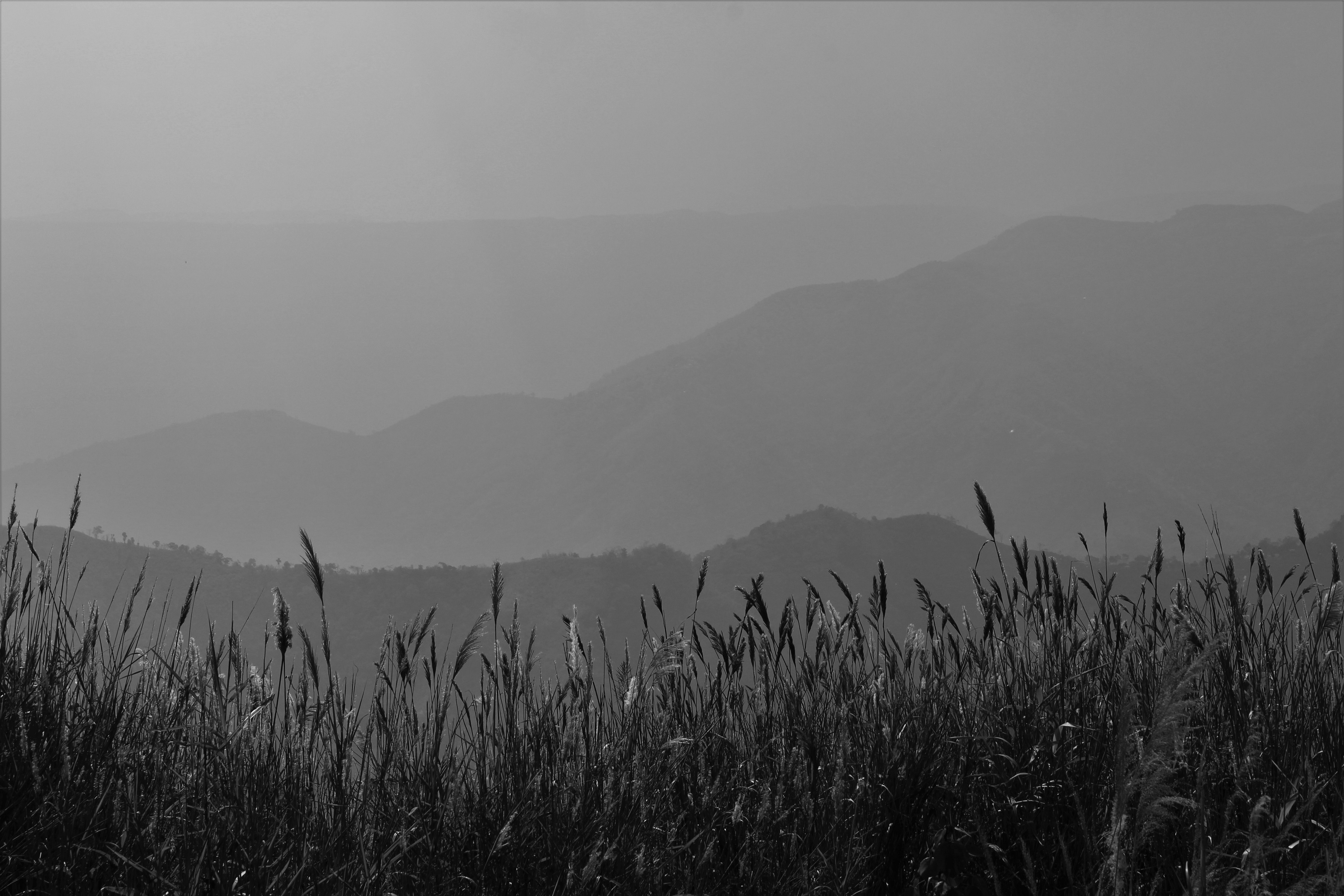
Set within a maze of steep valleys cut by a multitude of rivers, Katarshnong is perhaps the most complex piece of geography in all of Meghalaya. To the west, Sohra occupies a great flat-topped massif of limestone at an altitude of 4500 feet. Due east, a circuitous three-hour drive from Sohra though it is a mere eleven miles distant as the crow flies, Pynursla occupies its own limestone plateau, at roughly the same altitude.
Millions of years ago, these two vast chunks of fossiliferous stone were one, but then, as the whole Shillong Plateau violently rose, the monsoons and the raging rivers they spawned intervened, separating the two land masses with a deep bowl of many canyons, leaving only narrow fragments of the original tableland. Between the escarpments of Sohra and Pynursla, numerous rivers rush together to meet the Tharia, which takes that name, and collects the last of its Indian tributaries, just above the Bangladesh border. But before that final stretch, where the two fragments of ancient tableland curve in towards each other and the valley narrows, the Tharia river system is not characterized by a single, dominant stream, but by many similar, north-south flowing waterways, which each cut their own deep canyons, creating ridge after parallel ridge between the two higher limestone walls of the Tharia River Bowl. Steep mountains thousands of feet tall rise from the bottoms of the rivers, yet their summits are still far below the altitude of the tableland to the east and west. To walk the Tharia Bowl is to climb thousands of feet and still feel far under the surface. Katarshnong is set deep within this land of underground mountains, a part of Riwar, yet very much its own place, an island in the center of another island.

The four of us hadn’t even been planning on venturing into Katarshnong that day. We’d been up much of the night before discussing which route to take to a village called Kongthong. After hours upon hours of debate, collecting the valuable advice of many a villager, taking every conceivable factor into account, we settled on a path that would take us there at a relaxed pace over the course of the next three days, walking first north to the village of Wahkhen, which is east of the boundaries of Katarshnong, and then turning west from there to Kongthong. We went to bed happy that night knowing that there was a plan.
But waking up the following morning, we found that the plan, so laboriously arrived at, had to be abandoned: Morningglory and company learned they had a pressing engagement in Rangthylliang. We would have to try and reach Kongthong, and so the center of Katarshnong, the same day. This was a bit of a problem: Kongthong was very far away, and the path there, I could tell simply by looking out over the ridges to the west, would be a tough one.
Without breakfast, the four of us set out from Mynrieng at around six a.m. But there was something Morningglory and John Cena were desperate to see before we commenced our advance on Kongthong. They had been told that there was a small bat cave near Mynrieng. We reached this after a half hour walk, and it proved to be a perfectly satisfying cave, though rather lacking in the bat department. It turned out the locals had eaten most of them. We only found one. It was hanging from the ceiling of a large chamber, sleeping peacefully, when John Cena grabbed it with his bare hands, and then Morningglory photographed it by shining a headlamp in its face and taking snaps with his cellphone. I felt sorry for the unhappy mammal.
Following this only marginally successful bat bothering foray, we went to visit a beautiful, recent, living root bridge near the village. However, our guide from Mynrieng turned out to be something of a souse. My companions decided that they didn’t trust him, though they were unable or unwilling to explain why exactly (other than the man’s general sousiness). We all wound up sneaking away from him through the jungle to avoid further unpleasantness.
After our long souse-bypassing jungle creep, we met a trail that led straight down from Mynrieng, and, still having not eaten anything, began a 3000-foot descent to the Umrew River. I remember walking down and down and down, the ridge across the valley getting slowly closer and then towering high above us. In the morning, our altitude had been sufficiently lofty that we could look out over much of Katarshnong, and could see Kongthong, tiny in the distance. But now the many ridges of the Tharia Bowl rose up, cutting off the wider world. The air grew hotter with every step we took deeper into the hidden valley.
Now far from any village, we had entered a lonesome country. The path grew narrow and overgrown. We didn’t meet anyone on the way. Below, we saw a thin strip of blue, which quickly grew wider as we made our descent. Our path seemed to be taking us towards a large, deep pool in the Umrew, which was hemmed in by tall rocky bluffs. This was directly to our west, while the canyon of the Pynursla River cut through the land to the south. I theorized as we made our way down that the great pool must have been at about the point where the two rivers met.
It was after many hours of walking that we finally neared the merging of the rivers. Suddenly, the trail led us out onto a ledge over a tall, sheer, precipice, at the bottom of which was the last stretch of the Pynursla, which here flowed through a steep canyon. Our path led across this gorge via an old, long-abandoned bamboo bridge. All the poles of the bridge were grey and rotten, having not been changed out for what must have been several seasons. Some had snapped and were hanging uselessly out over the river. Judging by the ficus elastica tree positioned across the canyon, exactly at the other end of the abandoned bridge, it looked as though, once, there had been a living root bridge here, though this must have disappeared long ago. I knew that to step out onto the bamboo bridge was to face a watery grave, and so I wondered what the next move was.
John Cena soon provided the answer to this, one which, after having travelled with him for some time, I was less than surprised by. We would have to free climb down the last hundred feet of stone to the Pynursla. I sighed, knowing that this would be no easy feat, but also knowing that there was no other way. I guess by this point I was so used to walking the canyons that I had come to accept the fact that each day was going to have a good bit of danger mixed into it. It was never something I enjoyed for its own sake. I still don’t. Danger sucks. But I had to reach Katarshnong, for I knew that what I would find there would be worth the risk.
In any case, getting down to the Umrew was less difficult than it had looked. I couldn’t go the same way John Cena had due to my huge backpack (which none of my companions could carry … I really had too much crap with me on that trek). I wound up backtracking a bit and then climbing down several prominent stony shelves, first to the Umrew, and then to the mouth of the Pynursla canyon, where I met my companions in the middle of the stream.
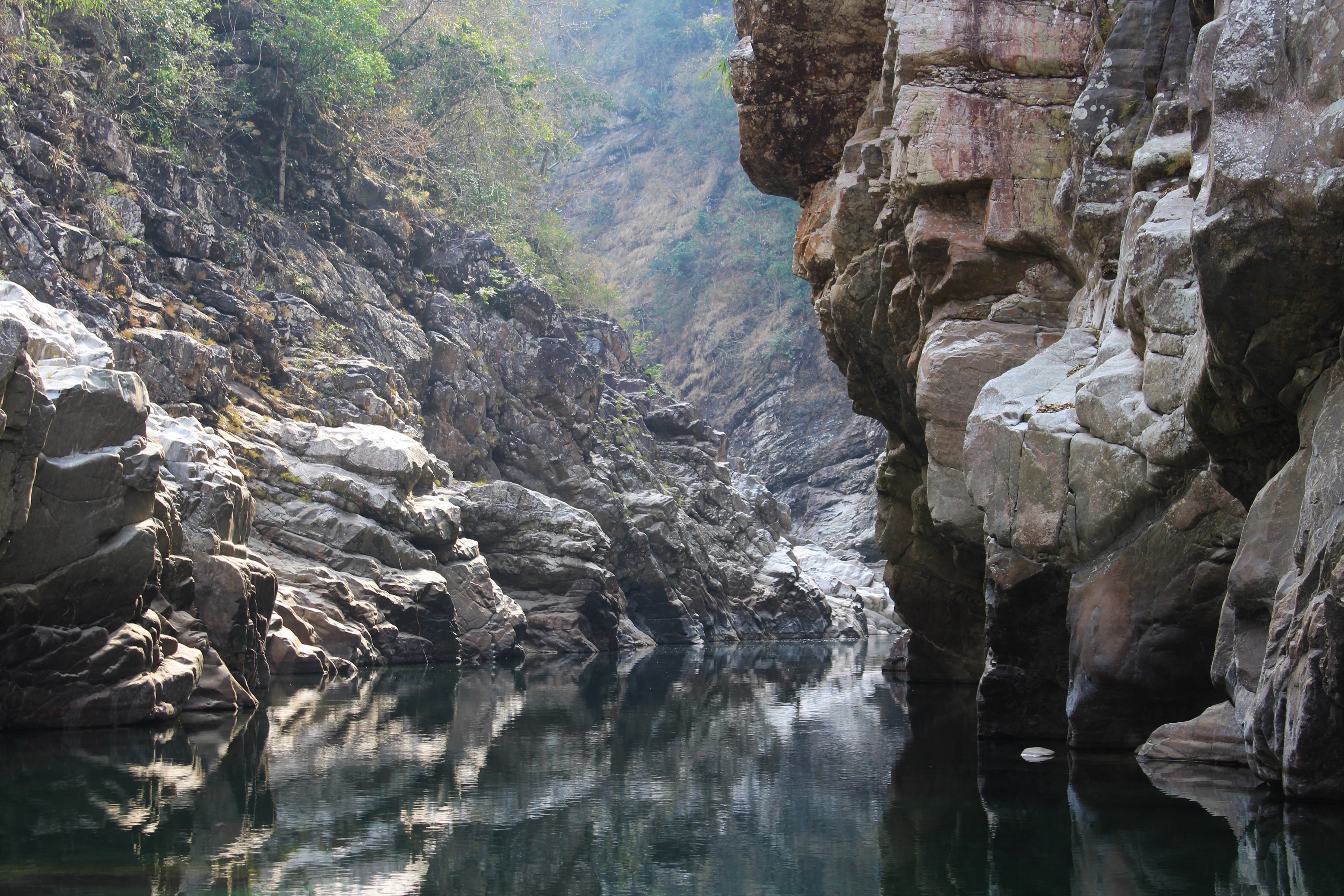
There, at the termination of the Pynursla river, we had reached the bottom of the world. All around us were great stony cliffs. Resting partially submerged in the deep, clear, Umrew, were vast boulders, the tops of them protruding above the surface like the peaks of icebergs. These had come from every stratum of rock above, brought down over the millennia by landslides, earthquakes, and innumerable monsoons. Huge pieces of weirdly eroded limestone full of marine fossils stood side by side with chunks of sandstone and colorful conglomerates. But the sheer stone of the cliffs, carved from the basement rock of Riwar, was vastly older than any of these. Even the higher strata of the Shillong Plateau are only as recent as the Mesozoic, and the fossils they contain are hundreds of millions of years old. But the deep, Precambrian stone that enclosed the Umrew comes from the very dawn of life on Earth. And now, after all the billions of years that stone had been in existence, here we were, one Phareng and three Rangthylliang Khasis, our little lives but infinitesimal pieces of a far, far, greater story.
We had lunch.
It was impossible not to linger a bit and swim among the ancient cliffs, but finally we pushed ourselves to walk on. Crossing a metal suspension bridge, we entered Katarshnong proper, and now made for a village called Mawmang, where we would stop for the night, having decided midway through our walk that Kongthong was simply too far away. Just as we had walked endlessly down to the Umrew, now we struggled endlessly up from it. For hour after brutal hour, the river shrinking behind us as the sun sank in the sky, we slowly ascended what seemed an infinite stairway.
Finally, close to sundown, we came to a village called Mawsohmad. This is a deep jungle settlement, far from any road, and a place where I gathered very few Pharengs had gone at that time. The local children screamed when they saw me. I felt bad for them and wanted to get through the village as soon as possible so as not to cause them any more discomfort. Morningglory and his dad went to talk to some of the villagers but had difficulty understanding their language. The place seemed to make my companions rather nervous, and I got the impression that they viewed themselves almost as out of place in Mawsohmad as I did. We managed to find a bit of water, and then pressed on.
Now we had been on our feet for twelve hours and still had many more to go. Hiking on from Mawsohmad, we accessed a path that headed north along the crest of a long, very narrow, ridge. This is one of the main thoroughfares in the region, linking moderate-sized, semi-accessible villages with rough road heads such as Jarain, Khrang, and Kongthong, with the remote settlements of Mawsohmad, Sder, Tluh, and other points deep within the Twelve Village’s forgotten jungles. To the east, the ridge falls away thousands of feet into the valley of the Umrew, and to the west, it tumbles steeply down to an obscure river called the Mein, which I have never seen up close. The path is the Katarshnong equivalent of a highway and is at almost the center of Riwar.
As we trekked on, the sun went down, but it was not dark. The moon was nearly full, and in its blueish light we could still make out all the folds and ridges of Katarshnong. Pynursla, where we had come from a few days before, was a flat line of illumination stretched along the top of the rim of the Umrew Bowl to our east, far above us even though we stood upon the highest point of land for hours in any direction. To the west, fainter, beyond the deep valleys of the Mein, the Muor, and the Nongpriang, was Sohra. Though it was only a few miles away, it would take me over a week to walk there. Between where I then stood and the town in the distance was a great deal.
Closer at hand, tiny groups of twinkling lights, glowing like star clusters, appeared as night fell. Dozens of villages seemed to hang in the moonlight itself. I didn’t know their names, but like Riwar, and like Katarshnong, I knew that each one was its own world, with its own history and myths, its own joys and sorrows, its own heroes and villains. They looked like such little places, yet no one person knew everything they contained.
Katarshnong is a little corner of Riwar, but Riwar itself is just a speck on the surface of the Earth. All of the events contained in this book happened in an area only around 35 miles across, and less than half that from north to south. But there’s a great deal in those few miles, and I fear I’ve missed most of it.
One could spend a lifetime travelling through Riwar and still not understand all that much about it. Is there a conclusion to be drawn from this? Probably, though I’m not sure what it is. After all these endless jungle treks, these brushes with danger, these stormy interludes, and these chance encounters with hundreds of people from a place so different from my home, I feel like I know less about Riwar now than I did when I first came to Meghalaya and caught that initial misty glimpse out over the forested canyons. Then, though I had not personally ventured into the gorges, I had a tidy mental picture of them, and that preconception was a thing which, in my own mind, made perfect sense. I thought that each valley, and each settlement, would be more or less the same, and that to learn what life was like in one village would be to learn what it was like across the region. But the great chasms swallowed that notion soon enough, and in its place left a kaleidoscope of memories far more incredible than anything I could have generated on my own.
The preconception did have the advantage of being easy to explain. My memories are not. Riwar doesn’t make sense to me anymore.
Of course, in terms of simply accumulating data about the place, I know more now than I did before, but the act of gathering information also served to put it in perspective. To answer a question was to generate ten new ones. The closer I focused in on Riwar, the more individual details shifted and divided and multiplied. I know well enough now that they’re never going to stop. A clear and fully coherent vision of Riwar isn’t someday going to coalesce out of this giant petri dish of mutating information. So, it seems to me one has ultimately to make peace with the fact that the human organism just isn’t up to the task of truly understanding every aspect of reality. Things can only appear to make sense because we can’t observe all that goes into them. But that’s what draws me back to the canyons. There’s always something new to find out.
We were still walking along the ridgeline trail, when, from somewhere far out in the distance, we heard a short, wordless song echoing through the moonlit valleys. It had a sweet sound to it, like a lullaby, yet it carried far. From a different direction came another short song, as if in response. This was followed by many others, which rose up from the blue ridges as though the hills themselves were singing to each other.
In a handful of villages in Katarshnong, there is a practice, to my knowledge unique in the world, where every person is given two very different names. One is a typical spoken word, but the other is a song, composed when the person is a baby. The compositions are always tender, exactly what one would expect a mother to make for the child she loves. They are used as a kind of tribal sonar; a song is sung into the valleys as a means of seeing who else is out there, and then other songs come back in reply, and the ether fills with a conversation made not from words but from melody.
As we walked along, we passed by a settlement, which was down the slope to our right, its lights twinkling in the distance. From the village issued the sound of many female voices singing out into the evening a sweet medley that drifted softly over the heart of the Khasi Hills. To this, from every direction, came answering songs from husbands, fathers, and sons singing back different tenderly composed themes to their loved ones. I had been walking for sixteen hours at that point and felt like I had undergone a year’s brutal exertion in a single day, but for those few hours along the moonlit ridge, there was no place that I would rather have been.
But we had a long way to go yet, and so we walked on, deep into the musical night.
THE END
Go here to read the rest of The Green Unknown
If you enjoyed this post, please consider supporting me on my Patreon page. There, you can download [BEGINNING JULY 2022!] a new extended edition of The Green Unknown which includes several chapters available exclusively on Patreon, as well as access a whole slew of other perks.