
The Khasi Hills were made by rivers. Coming to know the lay of the land in Meghalaya is therefore a study in hydrology. It may well be that underlying geological processes are what caused the Shillong Plateau to rise, but it’s the areas’ swift flowing waters which have scarred and eaten away at the plateau to give it its shape. Nearly all long treks in the southern Khasi Hills are walks into and out of river valleys.
One such Khasi valley is that of the Umkynsan, a stream which flows by Nongriat village. Its name meaning something like “The Strong River,” the Umkynsan originates at an altitude of about 5500 feet in the limestone table country near the village of Laitryngew. It terminates at its meeting with the Umiam River near the border of Bangladesh, having plunged over the course of its brief nine-mile journey a dizzying 5250 feet, gouging a deep canyon and gathering up several tributaries along the way.
The river’s name is well earned. Some of Meghalaya’s grandest waterfalls can be found along its length, and the Umkynsan’s gorge is a place just as lethal as it is beautiful.
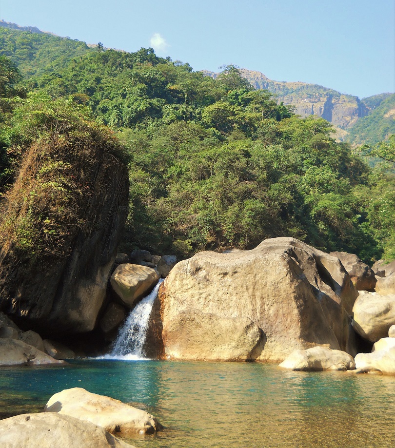
There is a pool in the Umkynsan, one of many, a few minutes’ walk north of Nongriat. It’s easy to find, being just next to the start of the trail that leads up to the river’s famous Rainbow Falls.
In the mild wintertime the pool is a marvelously serene place. Here the river has stripped the sides of the valley down to its bare bedrock, forming a sheer-sided gorge. The pool is oblong in shape, and only, maybe, sixty feet across at its widest. The stone that encloses the water has been beautifully smoothed by hundreds of thousands of years of natural abrasion. Near the surface of the pool the adjacent rocks are striped with horizontal white lines; watermarks which grow more frequent and lower down as the dry season progresses. The pool is deep, and diving into it one will notice that the temperature drops rapidly. The water becomes almost painfully cold in the stony depths. I’ve never reached the bottom.
While the pool is at an altitude where the climate is pleasant-to-hot all year round, up on the plateau where the stream originates there can occasionally be frosts in the winter. Mostly, the river is warmed by the time it reaches the lower altitudes, but it seems that the most frigid water sinks to the dark floor of the deepest pools of the Umkynsan and remains trapped there until the summer rains come and flood the whole valley.
The glassy surface of the pool is deceptively still, the current of the stream almost undetectable. The river enters the northern side of the gorge behind several large boulders, while it exits to the south through a gap between two rocks. This creates the illusion of the pool being not a stretch of river but an entirely enclosed body of water, and it makes it easy to forget that there is a huge volume of liquid forcefully moving through the small gorge every second.
This illusion persists even in the rainy season, when the strength of the Umkynsan increases a hundredfold. The level of the pool rises, and the water becomes more opaque, but the surface can appear just as smooth and glassy as ever, even when only a few feet below the river has developed a monstrous power.
During the monsoon, by the time the waters of the Umkynsan reach the pool they have already plunged in misty white falls and loud cataracts down several thousand feet. Now all of the collected force of every drop of water in the upper Umkynsan gorge is being squeezed through the narrow gap between the rocks. And yet, looking at the placid surface of the narrow lake, it’s hard to take in mentally that something so lethal could be hidden underneath. It was in this very pool in 2011 that the fellow traveler my brother and I met was instantly sucked under and never seen again.
In later years, revisiting the scene of the tragedy I would see whole families frolicking in the pool; noisy, middle-aged Bengali tourists who could barely swim; taciturn foreigners who were overconfident in their swimming abilities; puzzled Khasis from other parts of Meghalaya who wondered why these strange people felt the need to swim to begin with; all of them enjoying the truly beautiful spot and oblivious to the calamity that had occurred there.
There’s another pool, only a little further up the river, yet very different in character. It’s a surprisingly wide body of water; almost a lake. Unusual for Meghalaya’s mountain streams, the floor of the pool is sandy and shallow. This makes the water warmer than at other spots along the stream, which is welcome when it comes to swimming.
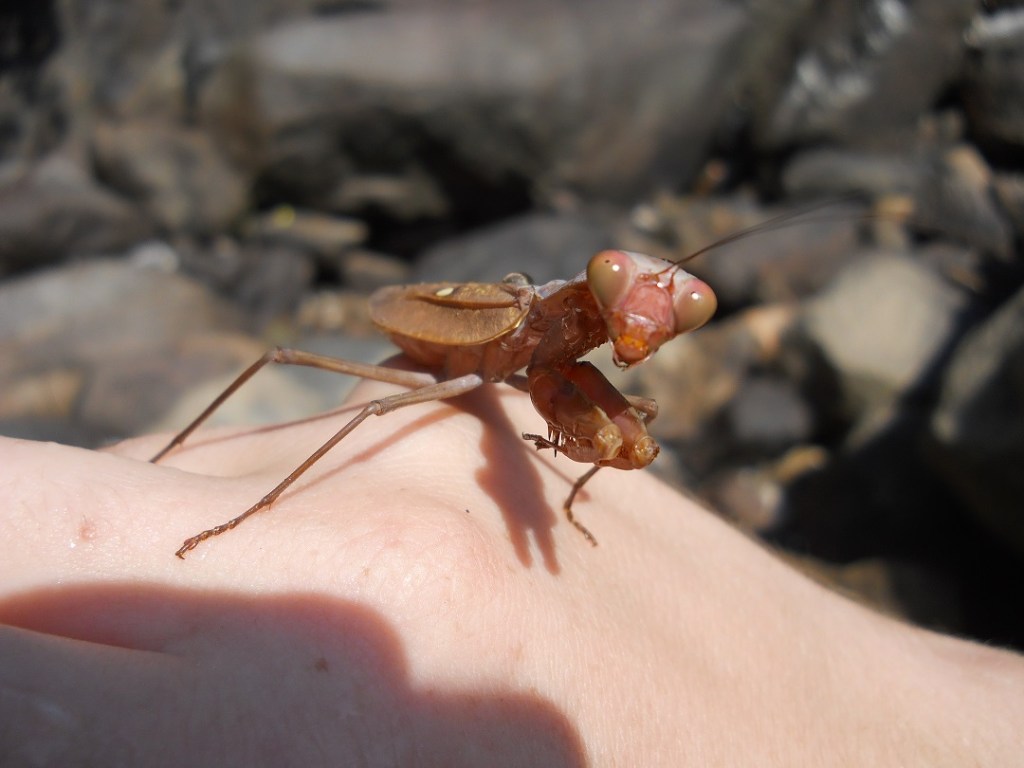
Once, I was beside this pool when I noticed a big praying mantis floating helplessly downstream. I reached into the water, picked up the insect, and tried to set it free in a nearby bush. But the mantis wasn’t having it. When I tried to set it down, it flew right back in my face, crawled on my head a bit, and then plunged right back into the river.
Shortly thereafter, I saw, yet again, a mantis riding helplessly on the waters of the Umkynsan. Its wings were open and it was futilely beating them against the water. I waded out to it and tried once more to be a Good Samaritan.
The moment I picked it up it flew into my face and jumped back into the water.
There seemed to be a theme here.
Now up to about my midsection in the river, I took note of the fact that there were many praying mantises riding helplessly along the current, frequently turning in little circles as they frantically kicked their legs and flapped their wings, certainly looking like they weren’t where they meant to be. It was hard to imagine any of the insects would survive a plunge over one of the Umkynsan’s falls downstream. But, then again, all of those I saw were alive. They had made it this far.
I tried picking up another one, but it immediately did a Kamikaze dive back into the water. Maybe they knew what they were doing. They certainly didn’t seem to appreciate my help.
There are two well-established routes up the valley of the Umkynsan. One is an ancient stone stairway that heads north from Nongriat, climbing steeply three thousand feet to the tableland above. The other, lower, trail is an altogether dodgier path which leads to Rainbow Falls.
Wisely, the old path was built to rise above the river as quickly as possible. Except for the sheer cliffs of black limestone that form the very highest rock stratum of the valley, the last few hundred feet above the waters of the Umkynsan are the roughest, steepest, part of the gorge. And even where the limestone makes the terrain nearly vertical, the rock is relatively stable, and the footing sure, unlike in the shifting deposits found just above the river.
As far as I can tell, the lower route is a trail that was only used by a few local agriculturalists before Nongriat became a tourist attraction. Now the path is significantly more frequented, yet it’s still a risky proposition. It leads through the steep, unstable terrain just above the river, up and down slopes where without a large investment in infrastructure a solid, easy to follow, not to mention safe, trail simply couldn’t be maintained.
The lower path branches off from the ancient stone stairway just after the latter crosses the Umkynsan via a steel-wire suspension bridge. The junction was once next to impossible to find without having a local showing you precisely where to look. Nelson Nongbri of Nongriat (unfortunate alliteration, my apologies), tells a story of a foreign visitor who came in the early days of tourism in the village. The man spent two months in Nongriat, and every day he would set out to find Rainbow Falls on his own. And, every day, he would wander off and get lost in the jungle. Nelson claims that he wanted to send a guide with the foreigner to direct him to the trail, but the foreigner always refused, hoping to succeed entirely on his own.
At least in the story, the man never reached Rainbow Falls. Whether or not this is true or just a ruse to prevent tourists from trusting their own judgement is hard to say. I could easily believe it’s a largely factual exaggeration (maybe it was two weeks rather than two months).
The upshot was that the good people of Nongriat decided to put up a sign.
But, even if you can find it, following the trail to Rainbow Falls is easier said than done. The land above the Umkynsan is so steep that in many places the “path” consists of small rectangular grottoes cut into the surface of the slopes. These are little more than rough handholds in a substance somewhere between loose dirt and clay. They’re no picknick going up, but getting down them is a particularly nervous descent. The footholds are in soft ground to begin with, and they’re made for people with Khasi proportions (therefore teeny tiny feet). If one is a full-sized foreigner and has a mind not to go down headfirst, one proceeds very slowly.
The trail is characterized by a variety of obstacles: rocks that can be easily dislodged by putting your weight on them; places where the way is so narrow one has to hold onto vegetation to remain upright; sections of path that have been recently eradicated by fallen trees and landslides, where new routes circumventing the obstructions are faint and steep.
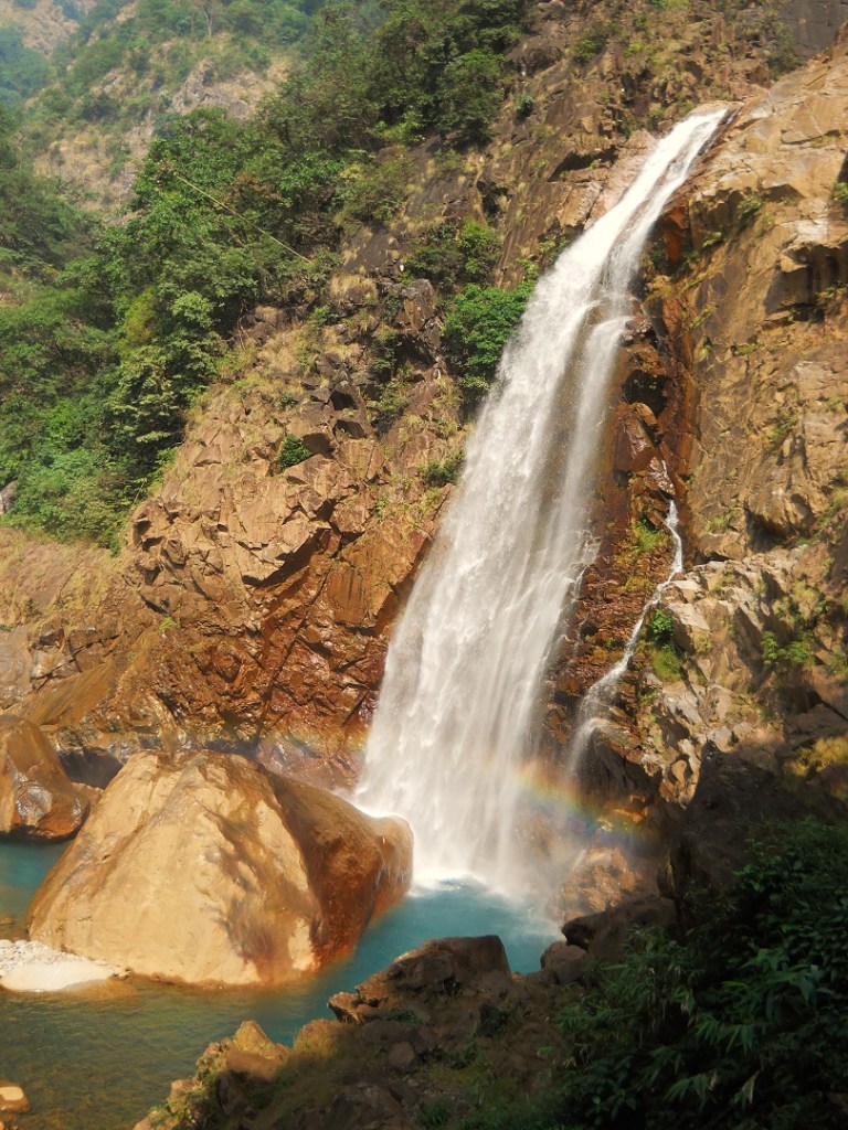
And then there’s the final stretch where the trail ceases entirely. This is just before Rainbow Falls, at which point the main course of the Umkynsan meets with several smaller streams. The primary river pours over a lofty cliff of polished red stone, perhaps a hundred and fifty feet tall, and crashes down into a deep, cold blue, plunge pool.
The tributaries descend over stony slopes into the plunge pool and into the river nearby. None are quite so dramatic as the falls, but they all scrape out sections of steep exposed bedrock, and the combined effect of all the different streams coming together and digging out the floor of the valley is something like a rocky cul-de-sac ending in the tall red cliff.
The last leg of the trek to rainbow falls is a climb down stone outcroppings. In the winter, when the falls are small and relatively tame, this stretch of the route is simply a scramble over rocks. But when the falls swell in size and power after a period of rain the whole cul-de-sac is misted in sheets of river water. When the Umkynsan is really roaring (a time when, I might add, one probably does not want to be there) every tree, rock, and hiker in the valley is blasted with cold water, and every stone surface is moist and covered in slippery algae.
The dry season is then, counterintuitively, the best time to go to Rainbow Falls. While the trail there is never easy, the difficulties are less imposing when there is no rain in sight.
Also, it’s during the dry season that you’re most likely to see where the “Rainbow” in Rainbow Falls comes from. When the sun is out, the mist of the falls acts as a prism, one that lasts most of the day, though it changes from hour to hour. In the surreal blue plunge pool that the falls have scraped out of the bottom of the valley there is a huge boulder, and it’s said that if one climbs this at the right time of day one can see the full seven-colored circle of the rainbow. Those who make their way to Rainbow Falls are amply rewarded…at least, in the dry season.
In wet weather the dangers of reaching the falls are significantly amplified while the reward is something grander but less beautiful. When its pouring and overcast there is, of course, no rainbow, and the falls themselves, rather than being a soft white curtain, are a huge brown deluge rocketing off a stony shelf above and then crashing into the floor of the Umkynsan valley, often taking boulders, trees, and other assorted detritus loudly down with it.
Here one has no trouble sensing the underlying power of the river. Indeed, when you’re standing in front of the cascade, it seems improbable that the brutal strength of the Umkynsan at Rainbow Falls and the deceptively calm, glassy surface of the pool downstream should have only a few miles between them.
One of the acute hazards of the Umkynsan canyon are landslides; and landslides, rather like earthquakes, are natural disasters that a person can’t do very much about when they’re confronted with one.
I happened to be leading my sister on a trek to Rainbow Falls one May morning. It had been pouring only a few hours before, but now the sun was beating down so hard that the whole jungle steamed. I subsequently learned that the combination of these two factors makes for prime landslide conditions. As the sun warms the saturated ground, it causes the water in it to expand as it evaporates, destabilizing the land. This can cause slopes to behave more like great masses of mud than solid ground.
The walk to the falls had been, as it always is, hair-raising, with many extreme ups and downs and several points where I wondered if I was being rather fool hardy bringing my sister along.
When we came to the cul-de-sac at the end of the trail, we found ourselves in the presence of a Rainbow Falls that was more than strong enough to cover all of the adjacent valley in a misty spray. We had packed a lunch, and had intended to eat it in comfort next to the falls, but this proved not worth doing; the only way to get out of the cold cascade was to hunker next to a rock.
It was really quite physically unpleasant, though the view was certainly worth seeing.
As we neared a shelf that overlooked the plunge pool, the ground suddenly began to shake. Then we heard trees snapping, and a loud rumble. Both of our hearts pounding, we instinctively looked to the right, where the noise was coming from. In the jungle the vegetation shook. Whole trees were being pushed aside as though King Kong was sprinting down the slope at us.
We did the one thing we could, which was to crouch beside a rock wall and hope that whatever was coming down the hill at us would pass us by. Fortunately, the slide (as we determined it was later) was relatively small and stopped up above. Nonetheless, the two of us were a little shaky for a while.
Once we got back to Nongriat I had a long conversation with Nelson about landslides. His view, one which I think has merit, is that other than during periods of extremely heavy rain or earthquakes, sudden bursts of intense sun after long bouts of precipitation are one of the times when a landslide is most likely.
I have factored his thoughts into my plans ever since.
Perhaps I’ve been making the trek to Rainbow Falls sound scarier than it is beautiful. But it’s the other way around. Most people get there and back with no problems (other than sweat and a lot of gasping for air), and if you don’t mind cold(ish) water, it’s an excellent, dramatic, place to swim.
And hell, the good people of Nongriat may very well have improved the trail since I last visited, in which case the dangerous romance of the place might now be rather diminished (and probably the crowds of tourists have increased). Then again, you might be less likely to die there. One has to take the good with the bad.
The people of Nongriat have to deal with a whole lot of shit when a tourist dies on their land, so if they want to improve the trail to Rainbow Falls they should go right ahead.
It’s beyond Rainbow Falls that the gorge of the Umkynsan gets really wild.
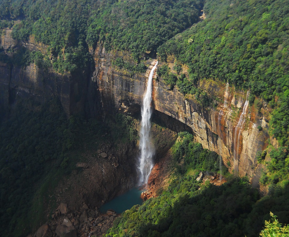
Here the base of the gorge climbs steeply to Nohkalikai Falls, by some measures the tallest single cascade in India. The river may descend 5250 feet in nine miles, but it loses close to forty percent of that elevation in less than a single mile between the top of Nohkalikai Falls and the bottom of Rainbow Falls. And, just as impressively, the river drops an incredible 1,115 feet in a single straight plunge at the former.
Nohkalikai means something to the tune of “Ka Likai’s jump.” There are several variations of the tale of how the falls came to be so named, though all of the stories I’ve come across have in common the pleasing themes of child cannibalism and suicide.
The more often-encountered story goes something like this: A woman named Ka Likai lived in a village called Rangjyrteh. Her husband, a porter, died, but she had a daughter to take care of, so she took up her husband’s job and then remarried. But whenever she would come home after work she would only have the energy to give attention to her daughter.
Over time, her new husband grew more and more jealous of his step-daughter. Finally, one day he couldn’t stand it anymore, so he took Ka Likai’s offspring, murdered her, cut her into little pieces, and cooked her. When Ka Likai came home after a long day of work, exhausted and famished, she saw that a meal had been prepared, so she sat down and ate it. It was only afterwards, when she found her daughter’s severed finger among her betel nut implements, that she realized that she had just ingested her own offspring.
Crazy with grief, she ran from her house and jumped off the top of the falls to her death.
The End.
Interestingly, there is another version of the story, which goes back at least as far as the first half of the 19th century, which is recounted in the journals of the intrepid Lieutenant Henry Yule.
(Aside: Lieutenant Yule is an interesting figure who provides many of the earliest surviving written accounts of life in the Khasi Hills. Notably, he seems to be the first person to ever have taken notice of the region’s living architecture. I discuss him in more depth in Through the Canyons of Living Bridges)
Yule’s rendering differs from the more widely known story in several key respects. In this version, Ka Likai is not a widow. Rather, she marries a foreigner (of what sort is not specified). The two of them move to a village (which is, again, not specified), near the falls, where they have two children, a boy and a girl.
One day, Ka Likai goes out to collect firewood, and then returns to find that her husband has cooked a great feast. The two of them sit down and finish eating, whereupon the foreigner husband informs Ka Likai that she has, you guessed it, just eaten her own offspring.
Then Ka Likai, crazy with grief, runs screaming from her village and jumps off the top of the falls to her death.
The End.
Now, Yule’s account is almost comically lacking in detail. No indication is given as to why Ka Likai’s husband cooked and ate (presumably) his own children. Maybe, from the perspective of whoever it was that told Yule the story, it was simply because he was a foreigner and therefore objectively wicked. But the good lieutenant doesn’t clarify.
Still, the two versions of the story, while very different in many small details, contain the same basic elements. In both, a woman is fed her own children by her awful husband and then driven to suicide by jumping off the falls.
As terrible as it is to contemplate, it’s impossible to rule out, even if it’s also impossible to prove, that in centuries past something like the awful story behind the name of India’s tallest waterfall actually occurred.
It’s easy to drive to an overlook where one can safely gaze on Nohkalikai falls in their entirety. Viewed from afar, the idea that the falls should have such a grizzly story behind them seems incongruous. The overlook has long since become a tourist trap where there are always noisy crowds of Assamese, Bengali, and Khasi day trippers. In an afternoon one can ride from Shillong not only to gaze upon the exquisite natural splendor of the falls, but also to patronize souvenir stalls that sell weird items as diverse as Narendra Modi bobble head dolls and chunks of driftwood carved to (slightly) resemble ducks.
From the overlook Nohkalikai Falls is far enough away that all sense of danger is lost. Instead what one gets is a pretty, if distant, picture. It’s possible to look, from behind a fence, over the northern end of the Umkynsan gorge, where a white ribbon of water has eroded a shallow U-shaped bite into the side of the limestone plateau. The falls launch straight off the side of the tableland and thunder down in front of a black limestone cliff into a surreal blue or green (depending on the season) lake. When it has rained lately several other secondary streams also empty to either side of the primary falls, creating a curtain of white water.
It’s a beautiful view, but from the overlook one is far away from the water. There’s no sense of scale. The lake looks like a shallow pool.
The only way to get a true sense of the sheer vastness of Nohkalikai Falls is to approach them from below; to stand on the shore of the cold lake carved out of the earth by the plunging waters.
This is not an easy thing to do. There are no prominent, well-maintained, trails that lead to the plunge pool. In the upper valley of the Umkynsan the land is still wild. A few agriculturalists from Nongriat will sometimes go into the area to gather wild edibles or to collect plants that grow better at higher altitudes than down by the village, but other than the ancient stone trail which rises thousands of feet above the river and entirely bypasses the area around the base of the falls, the only routes into the upper Umkynsan gorge are faint tracks created by animals or the occasional local who wanders in.
I had been told that it was possible to reach the Nohkalikai plunge pool simply by “taking the path above Rainbow Falls.” This was something of a mischaracterization. I tried to do this twice on my own, and the result was exactly like Nelson’s lost tourist. Without a guide, trying to reach the plunge pool is a fool’s errand. It might conceivably be possible to work your way up to the falls along the streambed of the Umkynsan, though it would be a steep scramble up and around giant boulders and stone cliffs. I suspect you would want climbing gear, especially if you were going down the same way.
And so, it was only with a guide from Nongriat that three companions from America and I actually managed to reach the base of the falls, and that was just barely. The way began by climbing several thousand feet up the ancient stone path, until, as nearly as I can figure, we were at about the same altitude as the plunge pool. Then the guide led us off the main trail, along a faint path through the forest that only a local would even think of following.
This trail soon bifurcated, became overgrown, and then faded out entirely. Far below us, down harsh, jungle-clad slopes, we could hear the roar of the Umkynsan coming up to us through the trees. Ahead, we could tell that the jungle opened out, and it was towards the clearing that our guide led us, hacking his own rout through the forest with his long-handled, sharp-bladed, dao (the preferred cutting implement in the Khasi Hills).
There was an incredible industriousness to the way in which our guide blazed through the jungle. He was a short fellow, of uncertain age. After the fashion of hard working Khasi jungle men, he had the fit body of a 20-year-old and the wrinkles of a 60-year-old. He felt little need to communicate with us, but the green wall of forest easily fell before him, allowing us to push deep into a place that we most certainly would never have entered without his help.
Still, the combination of steep slopes, thick jungle, and no discernable path led me to think that the success of the expedition was very much in doubt. Even with our guide slashing a tunnel through the forest ahead, footing was often difficult to find, and the trek became just as much an ordeal of balancing, crawling, and bypassing, as of walking. When we began to encounter small streams and were forced to cross recent, shifting, landslides, the feeling of uncertainty only grew.
But our guide was not one to be discouraged by (or even to comment upon) such a trifle as difficult terrain. In fact, as often happens in the Khasi Hills, he was such a good guide, and so used to dealing with these kinds of problems, that just keeping up with him became its own challenge.
The opening in the trees ahead grew nearer, and soon we could see the black band of limestone over which the falls plunged. To our left the sound of the river grew louder. While we were, as well as our guide could manage it, pressing roughly horizontally along the eastern side of the gorge, the Umkynsan was sloping quickly upwards. The stream was now so steep as to be nearly vertical.
Not far ahead there was a ridge of red stones. This was the southern rim of the plunge pool; the damn that the water backed up behind, and through which, via noisy white cataracts between boulders, the Umkynsan flowed out of the lake and down towards Rainbow Falls, and then Nongriat, and then the Ummiam, until its waters mixed with those of the larger river it met and crossed into the plains of Bengal.
With the rocks of the riverbed now visible below us, we were confronted with a new challenge. The way forward was over a slope of loose debris through which a small tributary of the Umkynsan cut a narrow canyon with unstable, crumbly, sides. There was no way to get around this without either going down to the main river, which was too steep to climb up from again, or heading uphill and hoping that we would find an easier crossing that way.
But our guide accepted neither of these options. Instead, he simply came to the edge of the canyon, looked it over, and then walked to a nearby tree that grew right next to the precipice. This he rapidly cut down, the trunk naturally falling over the gap and creating an instant bridge. He stomped down on this once to make sure it was stable, and then without a word calmly walked across it and disappeared into the jungle on the other side.
My companions and I all followed, rather more hesitantly.
When we came to the plunge pool it was in the middle of the dry season. The falls were at their least intense. With our heads tilted back to the sky we could gaze up and see a continuous curtain of mist launch off the plateau and then mostly dissipate in the air above. The majority of the water wasn’t falling directly into the pool but was instead softly raining down on the whole area, sprinkling wide swathes of jungle and dampening huge red stone outcroppings. Whenever there was a gust of wind the falls would gracefully twist and bend in the sky above.
It was amazing to contemplate that this same waterfall, which was now no more than a drizzle that barely reached the ground, had created the vast blue excavation in front of us. The Nohkalikai plunge pool is bordered on three sides with walls of sheer stone. It’s roughly oval in shape, narrowing at the northern end, where in the rainy season the falls hit with the most force, cutting a deep groove back into the side of the plateau.
This wall is the end of the Umkynsan gorge.
The pool is deep and cold. I’m not sure anyone has ever been to the bottom of it (alive, that is). When I visited, I felt almost obligated to take a swim, even though the water was so frigid, coming directly from the highland 1115 feet above, that I think hypothermia would have set in had I stayed in the water for more than a few minutes.
But we had some time to kill. So there, under the mist, my companions, the guide, and I, rested for a while and simply looked up and admired the strange splendor of the place we had come to with such difficulty.
The Umkynsan gorge, the Canyon of the Falls, is at once awesome and intimate, fearsome and soothing, horrifying and beautiful. It can easily kill you, and every inch of it is wonderful.
Go here to read the rest of The Green Unknown
If you enjoyed this post, please consider supporting me on my Patreon page. There, you can download [BEGINNING JULY 2022!] a new extended edition of The Green Unknown which includes several chapters available exclusively on Patreon, as well as access a whole slew of other perks.

One thought on “CHAPTER 5: THE CANYON OF THE FALLS”